This item has been sold, but you can get on the Waitlist to be notified if another example becomes available, or purchase a digital scan.
1887 Admiralty Nautical Chart of Hong Kong, Macau, Taiwan, Luzon, and Mindoro
ChinaSeaNorthernEastern-admiralty-1887$325.00

Title
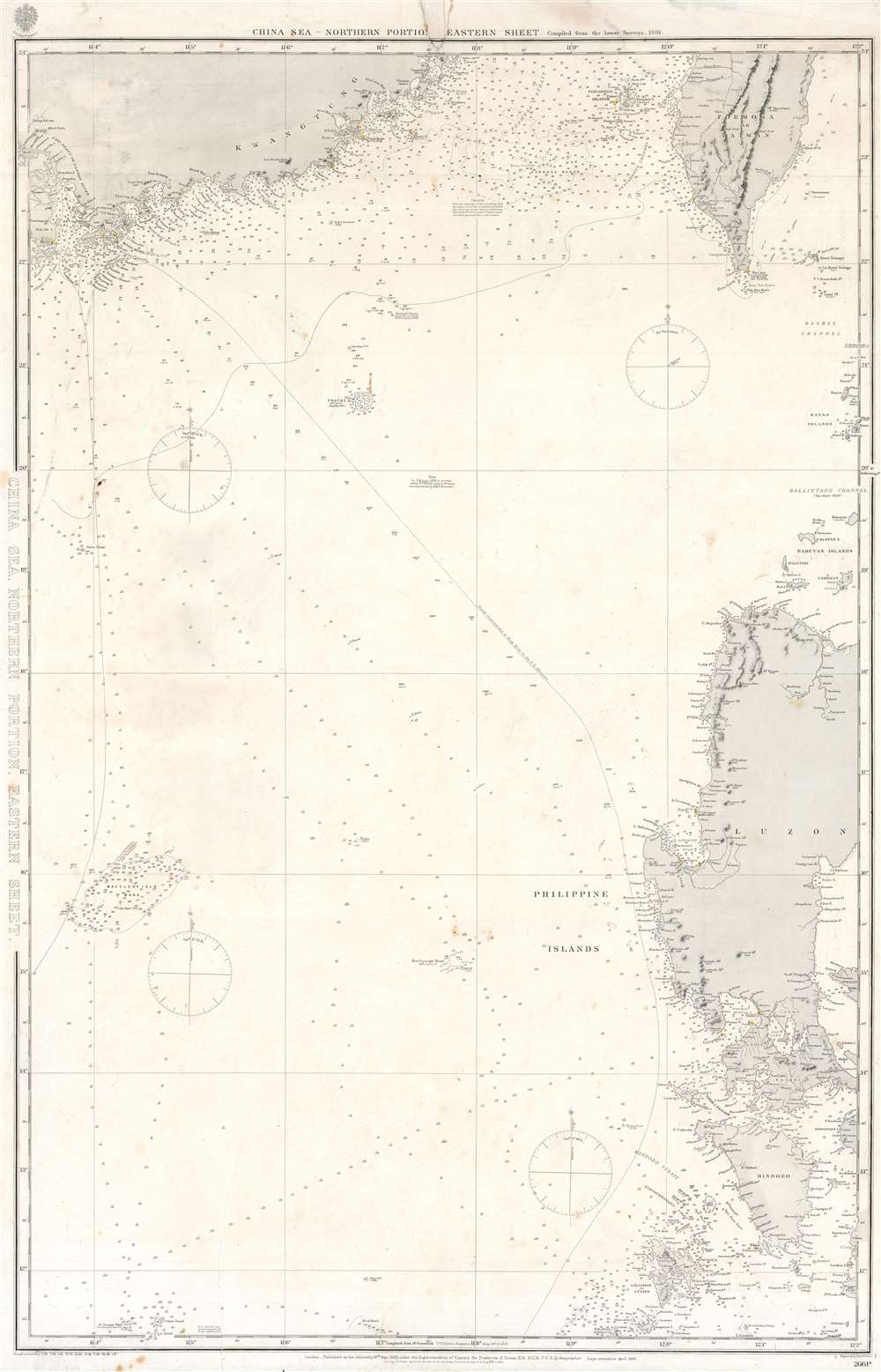
China Sea, Northern Portion, Eastern Sheet.
1887 (dated) 39 x 25.5 in (99.06 x 64.77 cm) 1 : 1400000
1887 (dated) 39 x 25.5 in (99.06 x 64.77 cm) 1 : 1400000
Description
This is an 1887 British Admiralty nautical chart or maritime map of the South China Sea. The map depicts the region from Macau (Macao) to the Batan Islands and from the Pescadores Islands to Panay Island in the Philippines. Myriad depth soundings are indicated throughout, with particular focus given to the Chinese coast the Strait of Formosa, and the coastal waters of the islands in the Philippines, including Manila Bay. Coastal cities and towns are labeled in all depicted areas, such as Macao, Victoria, Hong Kong, and Manila, as are bays, points, and other coastal features. Shoals, banks, and various other hazards are also noted. Coastal lights are marked by yellow dots.
Publication History and Census
An edition of this chart was first published by the Admiralty in 1882 under the superintendence of Captain Sir Frederick J. Evans, Royal Navy. This edition was published in 1887 to include the most recent information available to the Admiralty. This chart remains uncatalogued in the OCLC and we have been unable to locate any other examples.CartographerS
The British Admiralty Office (1795 - Present) or the United Kingdom Hydrographic Office refers to the Branch of the English government that is responsible for the command of the British Navy. In 1795 King George III created the United Kingdom Hydrographic Office, known in short as the U.K.H.O., to provide top notch nautical charts to the vast Royal Navy. Prior the founding of the Admiralty the surveying and creation of nautical charts was primarily a commercial venture wherein the cartographer himself, more of than not, actually financed the printing of his own material. The great navigator Cook himself is known to have scrambled for funds to publish his own seminal charts - the most important and advanced of the period. The system of privately funded nautical mapping and publishing left vast portions of the world uncharted and many excellent charts unpublished. King George III, responding significant loss in trade revenue related to shipwrecks and delay due to poor charts, recognized the need for an institutionalized government sponsored cartographic agency - the Admiralty. The first head of the Admiralty, a position known as Hydrographer, was the important cartographer Alexander Dalrymple. Dalrymple started by organizing and cataloging obtainable charts before initiating the laborious process of updating them and filling in the blanks. The first official Admiralty Chart appeared in 1800 and detailed Quiberon Bay in Brittany. By 1808 the position of Hydrographer fell to Captain Thomas Hurd. Hurd advocated the sale of Admiralty charts to the general public and, by the time he retired in 1829, had issued and published some 736 charts. Stewardship of the organization then passed to Rear Admiral Sir Francis Beaufort. It was under Beaufort's administration that the Admiralty truly developed as a "chart making" as opposed to a "chart cataloging" institution. Beaufort held his post from 1829 to 1854. In his 25 years at the Admiralty Beaufort created nearly 1500 new charts and sponsored countless surveying and scientific expeditions - including the 1831 to 1836 voyage of the H.M.S. Beagle. By 1855 the Admiralty's chart catalog listed some 1,981 charts. More by this mapmaker...
Captain Sir Frederick John Owens Evans (March 9, 1815 - December 20, 1885) was a career Royal Navy officer and hydrographer. Evans entered the navy in 1828 as a second-class volunteer. Evans served in on nine different ships before being named a master in 1841, aboard the HMS Fly. Evans and the crew of the Fly spent the next five years surveying the Coral Sea, the Great Barrier Reef, and the Torres Straits. Evans returned to the south seas in 1847, when he arrived in New Zealand with orders to survey the Middle and South Islands. He served in the Baltic Sea during the Crimean War. In 1855, well-known for his scientific knowledge, Evans was named superintendent of the compass department of the navy. He was named chief naval assistant to the Hydrographer of the Admiralty in 1865 and succeeded him in 1874. Evans resigned his post as Hydrographer in 1884 and in 1885 was appointed one of the British delegates to the International Meridian Conferenced in Washington, D.C. He died at his residence in London on December 20, 1885. Evans married Elizabeth Mary Hall on November 12, 1846. Learn More...
Edward Weller (July 1, 1819 - 1884) was a cartographer and engraver based in London. Weller was a nephew of another well-known map publisher Sidney Hall (1788 - 1831), who gave him 50 Pounds to pay his apprenticeship fees. He engraved for many prominent mapmakers and was active enough in the community to be recommended for membership to the Royal Geographical Society in 1851 on the recommendation of John Arrowsmith, among others. He eventually inherited the Sidney Hall map business which led him to follow Arrowsmith as the unofficial geographer to the Royal Geographical Society. Weller was among the first map printers in London to embrace lithography. His best known work appears in Cassell's Weekly Dispatch Atlas, published in monthly segments for subscribers of the 'Weekly Dispatch' newspaper. This collection of maps eventually grew to include much of the known world. Published in various editions from 1855 through the early 1880s. Weller died in May of 1884, leaving behind a successful business and an unhappy widow. His son, Francis Sidney Weller (1849 - 1910), followed in his father's footsteps and continued the family map business. The atlas Mackenzie's Comprehensive Gazetteer of England and Wales was published in 1894 and bore F. S. Weller's signature on the maps. Learn More...
Condition
Good. Even overall toning. Area of infill along top that includes part of printed title and border. Blank on verso.