1887 Admiralty Nautical Chart of Singapore, Malaya, Luzon, and the Mekong Delta
ChinaSeaSouthernWestern-admiralty-1887$750.00

Title
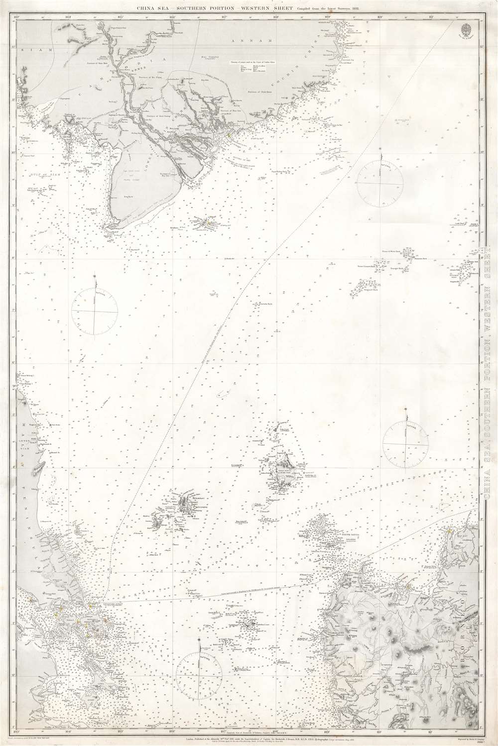
China Sea, Southern Portion, Western Sheet.
1887 (dated) 39.5 x 26.25 in (100.33 x 66.675 cm) 1 : 50488
1887 (dated) 39.5 x 26.25 in (100.33 x 66.675 cm) 1 : 50488
Description
This is an 1887 British Admiralty nautical chart or maritime map of Southeast Asia. The chart depicts the region from Singapore, the Malay Peninsula, and Sumatra to northern Luzon in the Philippines and from Cambodia and Vietnam (labeled here as Cochin China and Annam) to Sumatra and Luzon. Highly detailed, myriad depth soundings are indicated throughout, particularly along the coastline of Luzon, in the Straits between Sumatra and Singapore, along the coast of Vietnam, and tracing the habitual shipping lanes around the region. Cities, towns, and villages are identified, including Saigon, as are coastal landmarks, such as rivers and large hills. The dashed lines represent two different routes used to travel between Singapore and Hong Kong, both British possessions at the time of this chart's publication. Boundaries are indicated in Indochina between Cambodia, Lower Cochin China, Annam, and Siam.
Publication History
This map was created by the British Admiralty and originally published under the superintendence of Captain Sir Frederick J. Evans in 1881, with corrections on this particular example dating to 1887.CartographerS
The British Admiralty Office (1795 - Present) or the United Kingdom Hydrographic Office refers to the Branch of the English government that is responsible for the command of the British Navy. In 1795 King George III created the United Kingdom Hydrographic Office, known in short as the U.K.H.O., to provide top notch nautical charts to the vast Royal Navy. Prior the founding of the Admiralty the surveying and creation of nautical charts was primarily a commercial venture wherein the cartographer himself, more of than not, actually financed the printing of his own material. The great navigator Cook himself is known to have scrambled for funds to publish his own seminal charts - the most important and advanced of the period. The system of privately funded nautical mapping and publishing left vast portions of the world uncharted and many excellent charts unpublished. King George III, responding significant loss in trade revenue related to shipwrecks and delay due to poor charts, recognized the need for an institutionalized government sponsored cartographic agency - the Admiralty. The first head of the Admiralty, a position known as Hydrographer, was the important cartographer Alexander Dalrymple. Dalrymple started by organizing and cataloging obtainable charts before initiating the laborious process of updating them and filling in the blanks. The first official Admiralty Chart appeared in 1800 and detailed Quiberon Bay in Brittany. By 1808 the position of Hydrographer fell to Captain Thomas Hurd. Hurd advocated the sale of Admiralty charts to the general public and, by the time he retired in 1829, had issued and published some 736 charts. Stewardship of the organization then passed to Rear Admiral Sir Francis Beaufort. It was under Beaufort's administration that the Admiralty truly developed as a "chart making" as opposed to a "chart cataloging" institution. Beaufort held his post from 1829 to 1854. In his 25 years at the Admiralty Beaufort created nearly 1500 new charts and sponsored countless surveying and scientific expeditions - including the 1831 to 1836 voyage of the H.M.S. Beagle. By 1855 the Admiralty's chart catalog listed some 1,981 charts. More by this mapmaker...
Captain Sir Frederick John Owens Evans (March 9, 1815 - December 20, 1885) was a career Royal Navy officer and hydrographer. Evans entered the navy in 1828 as a second-class volunteer. Evans served in on nine different ships before being named a master in 1841, aboard the HMS Fly. Evans and the crew of the Fly spent the next five years surveying the Coral Sea, the Great Barrier Reef, and the Torres Straits. Evans returned to the south seas in 1847, when he arrived in New Zealand with orders to survey the Middle and South Islands. He served in the Baltic Sea during the Crimean War. In 1855, well-known for his scientific knowledge, Evans was named superintendent of the compass department of the navy. He was named chief naval assistant to the Hydrographer of the Admiralty in 1865 and succeeded him in 1874. Evans resigned his post as Hydrographer in 1884 and in 1885 was appointed one of the British delegates to the International Meridian Conferenced in Washington, D.C. He died at his residence in London on December 20, 1885. Evans married Elizabeth Mary Hall on November 12, 1846. Learn More...
Condition
Very good. Even overall toning. Closed margin tears professionally repaired on verso. Blank on verso.