
1924 White Map of Chocó Department, Colombia

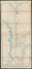
Intendencia Nacional del Choco. Plano general de la via Quibdo Negria y de algunas de sus conexiones.
A Planned Interoceanic Route in Colombia's Remote Northwest.
- Digital Map Information
- Suitable for large format printing
- Full resolution TIFF file
- ICC color profile embedded
- Delivered instantly via download link
A Planned Interoceanic Route in Colombia's Remote Northwest.
This is a c. 1924 map of the Chocó intendencia (now a departamento) in northwest Colombia, prepared by the territory's Anglo-Colombian engineer, Roberto J. White. The map presents an ambitious scheme White laid out to connect north- and south-running rivers in Chocó that empty into the Atlantic and Pacific Oceans, respectively, creating an interoceanic route capable of handling heavy cargo. This was a particularly important goal at the time as Chocó became one of the main international sources of platinum in the early 20th century and experienced a mining boom.A Closer Look
The map covers the entirety of the Chocó intendencia along with portions of neighboring territories, extending from the Darien Gap and the Caribbean in the north to Buenaventura and Cali in the south, and from the Pacific coastline in the west to Medellín, the Cauca River valley, and settlements along the western Andes in the east. Quibdó sits near the center, with Negría to the south (near Istmina, whose name combines the words for 'isthmus' and 'mine').The primary focus is the planned road between Quibdó and Negría (a planned 'puerto fluvial') via Istmina, but the map's much wider coverage places this titular road (named in the legend as 'via terrestre interoceánica') within a larger network of coastal ports, river landings, and inland markets. Prospective 'first class' roads, roads under construction, and railways are also traced. Thin black lines, such as the Camino Arquia - Urraro, appear to represent narrow pack animal paths used since the Spanish colonial era, if not earlier. Finally, the profusion of rivers and smaller waterways throughout the region is mapped, highlighting those capable of handling steamboats carrying up to 500 tons, most notably the Atrato and San Juan Rivers. In the end, this plan was never implemented, and Negría never developed into a port, being little more than a place name on the map today.
The Planned Quibdó - Negría Interoceanic Route
The conceptual roots of an interoceanic route connecting the Atlantic and Pacific Oceans through Chocó date to the colonial era, notably marked by early attempts like the 18th-century Raspadura Canal. In 1924, Roberto J. White, then Ingeniero Intendencial of Chocó, revived this vision by drafting the map shown here. White's initiative focused on bridging the gap between Quibdó, on the north-flowing Atrato River that empties into the Caribbean, and Negría, on the south-flowing San Juan River that empties into the Pacific. By mapping the hydrography and terrain across the Isthmus of San Pablo, White envisioned a modernized interoceanic transit corridor that could link both river systems via a complementary overland road to ship heavy cargo.The immediate impetus for such a project was the platinum mining boom in Chocó in the early 20th century, which overburdened existing means of transporting goods through the region. In this era, the Chocó region was a primary global source of platinum, especially as World War I (1914 - 1918) and the Russian Revolution disrupted Russian supply chains and drove international demand higher. Foreign capital, most notably through the American-backed South American Gold and Platinum Company, flooded the San Juan, Condoto, and Atrato river basins, introducing heavy industrial dredging from 1916 onwards. While mechanization dramatically increased yields and made Chocó one of the world's leading platinum exporters, it also sparked severe socio-environmental conflicts. Corporate dredging operations frequently displaced long-established Afro-Colombian barequeros (small-scale miners) from their ancestral waterways, polluted river systems, and siphoned profits abroad, establishing an extractive economic model that left local communities facing ecological degradation and economic marginalization despite living alongside one of the world's richest platinum deposits.
Beyond serving as a gateway for platinum exports and a domestic alternative to existing interoceanic trade routes (i.e., the Panama Canal), White's plan aimed to break Chocó's geographical isolation by integrating its interior river ports into Colombia's broader national economy. Fiscal limitations, dense, mountainous rainforest terrain, and shifting national infrastructure priorities ultimately prevented the full development of a heavy-capacity canal or unified highway along this route. Locals also point to the role of neglect from the national government and structural racism, as Chocó is one of the parts of Colombia with the highest concentration of Afro-Colombians. Still, White's 1924 plan provided a baseline for subsequent mid-20th-century public works in the department, including part of Ruta Nacional 13, which connects Quibdó and Istmina.
Publication History and Census
This map was prepared by engineer Roberto J. White, the official engineer for the intendencia of Chocó. It is undated but is presumed to date to 1924. The map is also signed by Rodolfo Castro Baldrich, the lead engineer for road construction (Ingeniero director del Camino Quibdó-Istmina), and the territorial administrator Miguel Vargas Vásquez (Intendente Nacional del Chocó), underscoring the importance of the planned project. The map was printed by the state-run Litografía del Estado Mayor General, which generally produced maps for military purposes. This map is rare. It is cataloged at only two institutions: the British Library and the Biblioteca Luis Ángel Arango.Cartographers
Roberto J. White (fl. c. 1918 - 1928) was a civil engineer (Ingeniero Intendencial) in the department (then intendencia) of Chocó in Colombia best known for planning a never-completed 'interoceanic' road between Quibdó and Negría, and producing a related 1924 map. He was part of the prominent Blake White - Uribe family of Colombia, descended from three British brothers from the Isle of Wight who settled in Colombia and worked as mining engineers in the 1860s. One of the brothers, Robert (or Roberto, 1840 - 1907), married María del Rosario Prudencia Uribe (his younger brother, John Henry White Blake, 1846 - 1925, married María Rita Eugenia Gregoria Uribe, presumably a relative of María del Rosario Prudencia Uribe). Roberto J. White Uribe was one of the children of Robert White Blake and María del Rosario Prudencia Uribe. Several members of his extended family (particularly his cousins - the sons of John Henry) also became prominent in mining and related fields in the late 19th - early 20th century. Aside from his unrealized Quibdó-Negría road, White was involved in early surveys and planning for roads designed to connect Chocó's isolated interior with neighboring departments, including early route options for the Quibdó - Medellín route, a decades-long project through treacherous mountainous terrain. Further Details...
Litografía del Estado Mayor General (c. 1895 - 1935) served as the official lithographic press and cartographic publishing office for the General Staff of the Colombian Army. Established in Bogotá as the Imprenta del Comando General (sometimes also as Imprenta del Estado Mayor General), it functioned as the state body for converting field surveys, military reconnaissance, public works blueprints, and territorial studies into standardized official maps. The press published maps and documents ranging from regional infrastructure plans to strategic border maps created during geopolitical crises, including the 1932 - 1933 Colombia - Peru War over the Amazonian Trapezium. It also served as an institutional bridge between early 19th-century private printmaking and the establishment of centralized state agencies like the Instituto Geográfico Militar y Catastral in 1935. Further Details...
Condition
Very good. Toning. Laid down on dark green linen by publisher.
References
OCLC 557219651. Biblioteca Luis Ángel Arango, Depósito C2 LRM ; PC3-197.