
1942 WWII German Propaganda Map of the World: Allies' Colonial Empires


This item has been sold.
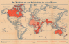
Die Weltkarte mit dem Kolonialbesitz der Großen Mächte. / [The World Map with the Colonial Possessions of the Major Powers.]
Nazi criticism of Allied Colonial Imperialism.
Choose a Collection:
- Digital Map Information
- Suitable for large format printing
- DPI: 600
- File Size: 40.65 MB
- File Type: ZIP / TIFF
- ICC color profile embedded
- Delivered instantly via download link
This Item
Enquire
Nazi criticism of Allied Colonial Imperialism.
This is a 1942 German World War II era anti-Allied propaganda map of the world criticizing Allied imperialism. Colonial imperialism was a favorite point of attack used by Nazi propagandists to criticize what they considered Allied hypocrisy.A Closer Look
This large world map highlights, through an array of coding-schemas, colonies belonging to Allied and neutral nations. The vast colonial reach of Britain, in particular, was key to the Allies' ability to wage a global war against the powerful Third Reich.Although Nazi propaganda pushers were quick to attack Allied colonialism, it was certainly not out of compassionate feelings towards oppressed peoples. Germany itself was late to the 'Colonial Game', only establishing a few colonies in Africa and Asia in the late 19th and early 20th centuries. These were lost during and after World War I (1914 - 1918), an event which engendered general resentment among the German populace that was easily stoked by the Nazi regime. Throughout World War II (1939 - 1945), the Third Reich nursed plans to regain and expand these lost claims, particularly in Africa.
Publication History and Census
This map was published by Carl Lange Verlag in 1942 in Duisburg, Germany. We note 2 cataloged examples in OCLC which are part of the collections at the Deutsche Nationalbibliothek Leipzig and the Herder-Institut für historische Osmitteleuropaforschung-Institut der Leibniz-Gemeinschaft, Forschungsbibliothek. No market history.Condition
Good. Soiling and toning. Wear along original fold lines. Slight loss at a few fold intersections and small areas of infill at 2 fold intersections. Closed margin tears professionally repaired on verso.
References
OCLC 719221007.