1795 Carey / Doolittle Map of Connecticut
Connecticut-carey-1795$600.00

Title
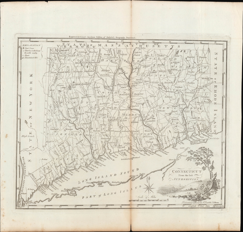
Connecticut from the Best Authorities.
1795 (undated) 12 x 14.5 in (30.48 x 36.83 cm) 1 : 462500
1795 (undated) 12 x 14.5 in (30.48 x 36.83 cm) 1 : 462500
Description
A fascinating 1795 map of the state of Connecticut, drawn and engraved by Amos Doolittle for Matthew Carey's Carey's American Edition of Guthrie's Geography Improved, the first atlas published in the United States of America.
As indicated in a legend at top-left, illustrations mark cities and towns hosting courthouses, including New York City, New Haven, Hartford, Tolland, Litchfield, Danbury, Windham, and New London. The title cartouche includes an illustration of a coastal area with ships on the water, along with the state motto 'Qui transtulit sustinet,' harkening to the state's colonial history.
A Closer Look
The state of Connecticut is displayed as divided into counties. Cities and towns, roads, hills, waterways, and other features are noted throughout. Along the coast, points, harbors, beaches, and hazards are all recorded. The lighthouse near New London is the New London Harbor Light, built in 1760, the earliest lighthouse in Connecticut and the only one at the time of this map's publication. Fort Griswold, also near New London, was captured by the British (under Benedict Arnold) during the Revolutionary War in 1781, before being abandoned and recaptured by the Americans.As indicated in a legend at top-left, illustrations mark cities and towns hosting courthouses, including New York City, New Haven, Hartford, Tolland, Litchfield, Danbury, Windham, and New London. The title cartouche includes an illustration of a coastal area with ships on the water, along with the state motto 'Qui transtulit sustinet,' harkening to the state's colonial history.
The 'Oblong'
Notable in the western part of the state is the 'Oblong,' marked out with a dashed line. This area was the site of disputes between landowners dating back decades, itself the result of a broader territorial dispute between the colonies of New York and Connecticut. Although the colonies had resolved their disagreements in 1731, by setting aside the 'Oblong' as compensation to New York for the Connecticut Panhandle, New York landowners did not always enforce their ownership claims. This laxity allowed squatters to move in and claim rights to the land after several years. This problem was especially acute along the border with Putnam County, New York, owned by the Philipse Family. However, as the family were ardent Loyalists during the American Revolutionary War (1775 - 1783), the problem was mostly resolved at the end of the conflict when their lands were confiscated and the squatters given deeds.Publication History and Census
This map was drawn and engraved by Amos Doolittle for inclusion in Matthew Carey's Carey's American Edition of Guthrie's Geography Improved, published in Philadelphia in 1795. The same map also appeared in the largely overlapping Carey's American Atlas, published soon afterwards. Regardless of printing, roughly ten institutions independently catalog this map in the OCLC, though the intermingling of digital and physical examples makes a precise census difficult.CartographerS
Matthew Carey (January 28, 1760 - September 16, 1839) was a Dublin born publisher who established himself in Philadelphia in the late 18th and early 19th century. A young man of socially progressive views, Carey's first known publication, produced when he was but 17 years old, was a pamphlet criticizing dueling. Another pamphlet, issued in the same year, attacked the Irish penal code. Shortly afterwards, in 1779, legal issues, possibly arising from his liberal political activism, forced Carey to flee to Paris. In Paris, Carey had the good fortune to befriend the visiting American diplomat and founding father, Benjamin Franklin (1706 - 1790). As an Irishman chafing under the rule of England, Carey sympathized with and admired the American revolutionary. The liberally minded pair struck up a lifelong friendship and Carey was hired to work at Franklin's press in Passy, France. A year later, Carey returned to Ireland and resumed his politically provocative publishing career with The Freemans's Journal and The Volunteer's Journal. It didn't take long for political pressure to once again force Carey from Ireland - this time to America (1784). Although largely without funds, Carey convinced Gilbert du Motier, Marquis de Lafayette (1757 - 1834), who he knew from Franklin's Paris circle, to lend him funds to establish a new publishing concern in Philadelphia. Despite this loan, Carey's firm remained under financed and opened on a shoestring budget. It was most likely his limited budget that led Carey to some of his most important publishing innovations. At the time cartographic publishing was dominated by large printing houses in London and Paris where most, if not all, of the work was completed in house. Without the finances to emulate this large publishing houses, Carey was forced to outsource much of his publishing work. This set the stage for subsequent American publishers who, in order to compete effectively with European firms, relied on an often bewildering network of alliances and collaborations. Carey was also a master of republishing many of his own maps in multiple different atlases and formats to maximize their profitability. His most important work is without a doubt the 1795 issue of the American Atlas the first atlas to be published in America. Carey died in 1839 but was succeeded by his son Henry Charles Carey (1793 - 1879) who, in partnership with his brother-in-law Isaac Lea (1792 - 1886), published numerous important maps and atlases under the Carey and Lea, Lea Brothers, and Lea and Blanchard imprints. More by this mapmaker...
Amos Doolittle (May 18, 1754 - February 2, 1832) was an American engraver, silversmith, and map publisher active in Connecticut during the late 18th and early 19th centuries. Most likely because of the overlap in their careers and lifetimes, Doolittle is often referred to as the 'Revere of Connecticut'. He was born in Cheshire, Connecticut, the son of Ambrose and Martha Munson Doolittle. He apprenticed under the silversmith Eliakim Hitchcock. Doolittle was a self-taught artist who specialized in copper engraved scenes from the American Revolutionary War. Having acquired a considerable reputation as an engraver, Doolittle was sought out by many early Americans eager to learn the art, including James Wilson and Ralph Earl. Cartographically Doolittle is recognized for engraving several important maps of New Haven and Connecticut. Later in life he began publishing as 'Amos Doolittle and Son', having brought his sone into the business. We do not know who this is, but at least one imprint is signed 'Amos and A. B. Doolittle', so he may be Amos Jr.? During the Revolutionary War he served under Benedict Arnold as a member of the Governor's Second Company of Guards. Following the war he settled in New Haven, Connecticut and is buried in that town's Grove Street Cemetery. Learn More...
William Guthrie (1708 - March 9, 1770) was a Scottish historian, journalist, and writer. Born in Brechin, he studied at Aberdeen University with the idea of becoming a parochial schoolmaster. Instead, in 1730, he elected to settle in London and try his hand at literature. He covered parliamentary debates f or the Gentleman's Magazine and soon earned a reputation for being a political writer. He published several scholarly works, including a History of England from the Invasion of Julius Caesar to 1688 in four volumes, and, most notably, his Geographical Historical, and Commercial Grammar. Learn More...
Source
Carey, M., Carey's American Edition of Guthrie's Geography Improved, (Philadelphia) 1795.
Condition
Fair. Mended along centerfold split. Light foxing outside border.
References
Rumsey 2542.006. OCLC 5565254, 950941475, 163340530.