This item has been sold, but you can get on the Waitlist to be notified if another example becomes available.
1961 U.S. Army Map Service Map of Death Valley National Monument and Environs
DeathValley-armymapservice-1961$100.00

Title
Death Valley.
1961 (dated) 22 x 31 in (55.88 x 78.74 cm) 1 : 250000
1961 (dated) 22 x 31 in (55.88 x 78.74 cm) 1 : 250000
Description
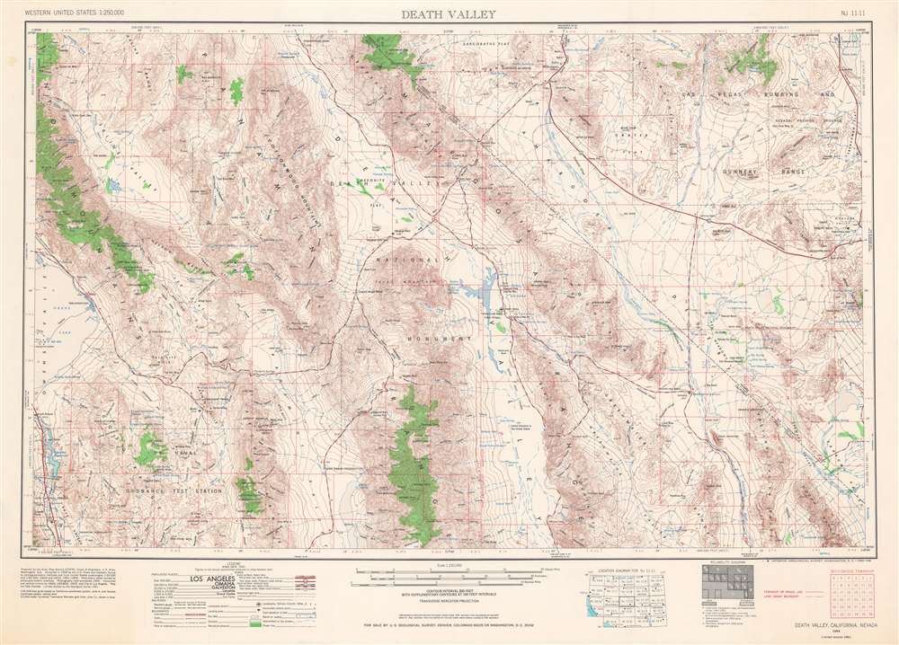
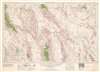
This is a 1961 U.S. Army Map Service map of Death Valley National Monument (now a National Park), with surrounding mountain ranges and valleys along the California-Nevada border in the Mojave Desert. This map reflects the history of the region, which has been inscribed onto the landscape in the form of Native American settlements, abandoned mines, federally protected land, and military testing sites, including nuclear testing sites.
At top-right is the Las Vegas Bombing and Gunnery Range, also known as the Nevada Test Site, where hundreds of nuclear weapons were developed and tested from 1951 until the 1990s. Most of the tests occurred in areas to the north, although a handful were conducted at Shoshone Mountain, Yucca Flat, and Frenchman Flat at top-right. These included Operation Ranger at Frenchman Flat, the first test conducted at the Nevada Test Site in January 1951, and the Sedan nuclear test in 1962, which caused one of the worst instances of radiation fallout of all nuclear tests conducted by the U.S. during the Cold War. The Sedan test was part of Project Ploughshare, which ironically was designed to examine peaceful civilian uses for nuclear explosions, such as mining and highway construction.
At center sits Death Valley National Monument, proclaimed on February 11, 1933, by President Herbert Hoover. The location of abandoned mines and railways, evidence of a short mining boom at the end of the 19th century, are also scattered throughout. An extensive legend indicates administrative, infrastructural, and geographic information.
The first group of American settlers came to the region in 1849 looking for a shortcut to the gold fields of California. They were lost in the valley for several weeks and barely survived, leading to the name by which the area is now known. Soon afterwards, the region underwent a mining boom, not so much in gold and silver as salts, borate, and talc, which are readily abundant there. But rapid depletion of the easiest-to-access resources and a financial crisis in 1907 spelled the beginning of the end for the mining boom, with mines and miners' camps rapidly abandoned.
The Civilian Conservation Corps undertook several projects in the region during the Great Depression, including the 'Indian Village' that was later the basis for the reservation. Most of the projects, however, focused on roads and other infrastructure which allowed for the large number of military facilities that operated there during World War II and in the postwar period.
Although Death Valley National Monument protected a considerable amount of land from certain forms of development, mining continued to be allowed and recovered from its early 20th century bust, utilizing new technologies like open pits and strip mines that had negative environmental impacts. Regulations increased and mines closed towards the end of the 20th century, especially after the protected land was enlarged and redesignated as a National Park in 1994.
A Closer Look
The map covers a region of the Mojave Desert due west of Las Vegas, along the California-Nevada border, which cuts diagonally across the right-hand side. Since being incorporated into the United States, much of this land has belonged to the federal government. At bottom-left is the U.S. Naval Ordnance Test Station (now known as the Naval Air Weapons Station China Lake), the U.S. Navy's largest landholding at over a million acres, a territory larger than Rhode Island.At top-right is the Las Vegas Bombing and Gunnery Range, also known as the Nevada Test Site, where hundreds of nuclear weapons were developed and tested from 1951 until the 1990s. Most of the tests occurred in areas to the north, although a handful were conducted at Shoshone Mountain, Yucca Flat, and Frenchman Flat at top-right. These included Operation Ranger at Frenchman Flat, the first test conducted at the Nevada Test Site in January 1951, and the Sedan nuclear test in 1962, which caused one of the worst instances of radiation fallout of all nuclear tests conducted by the U.S. during the Cold War. The Sedan test was part of Project Ploughshare, which ironically was designed to examine peaceful civilian uses for nuclear explosions, such as mining and highway construction.
At center sits Death Valley National Monument, proclaimed on February 11, 1933, by President Herbert Hoover. The location of abandoned mines and railways, evidence of a short mining boom at the end of the 19th century, are also scattered throughout. An extensive legend indicates administrative, infrastructural, and geographic information.
Context
Perhaps more than anything else, Death Valley is famous for its incredible heat. The U.S. Weather Bureau recorded a temperature of 134 degrees Fahrenheit at Furnace Creek (near center) on July 10, 1913, still the highest ambient air temperature ever recorded. Still, despite its name and worthwhile reputation as a difficult place for human habitation, there were a succession of Native American groups who settled seasonally in the valleys shown here, most recently the Timbisha (often called Timbisha Shoshone in the past). In 1982, a small reservation called the Death Valley Indian Community was created at Furnace Creek (marked here as 'Indian Village'), later expanded in 2000 to 7,500 acres.The first group of American settlers came to the region in 1849 looking for a shortcut to the gold fields of California. They were lost in the valley for several weeks and barely survived, leading to the name by which the area is now known. Soon afterwards, the region underwent a mining boom, not so much in gold and silver as salts, borate, and talc, which are readily abundant there. But rapid depletion of the easiest-to-access resources and a financial crisis in 1907 spelled the beginning of the end for the mining boom, with mines and miners' camps rapidly abandoned.
The Civilian Conservation Corps undertook several projects in the region during the Great Depression, including the 'Indian Village' that was later the basis for the reservation. Most of the projects, however, focused on roads and other infrastructure which allowed for the large number of military facilities that operated there during World War II and in the postwar period.
Although Death Valley National Monument protected a considerable amount of land from certain forms of development, mining continued to be allowed and recovered from its early 20th century bust, utilizing new technologies like open pits and strip mines that had negative environmental impacts. Regulations increased and mines closed towards the end of the 20th century, especially after the protected land was enlarged and redesignated as a National Park in 1994.
Publication History and Census
This map was prepared by the Army Map Service of the Corps of Engineers, incorporating data from the U.S. Coast and Geodetic Survey. This is a 1961 revision by the U.S. Geological Survey to an original 1954 edition. The map is sometimes cataloged (OCLC 669445268) as being published in 1966 because of the note at bottom-right – 'Interior-Geological Survey, Washington, D.C. – 1966 – NS' - though it is not clear if this note refers to the year of publication or not. In any event, the map is only held by a handful of institutions in the United States and is scarce to the market.CartographerS
The Army Map Service (AMS) (1941 - 1968) was the military cartographic agency of the U.S. Department of Defense and part of the U.S. Army Corps of Engineers. The AMS compiled, published, and distributed military topographical maps and other related materials for use by the U.S. Armed Forces. They also prepared maps for space exploration, intelligence reports, and the establishment of world geodetic control networks. Formed during World War II, by the end of the war the Army Map Service had prepared 40,000 maps. 3,000 different maps were created for the Normandy invasion alone. The AMS was instrumental in the Korean War and the Vietnam War, and during all three of these conflicts distributed tens of millions of maps to U.S. servicemen. On September 1, 1968, the AMS was resdesignated the U.S. Army Topographic Command, and continued under this name as an independent organization until January 1, 1972 when it was merged with the new Defense Mapping Agency and renamed the DMA Topographic Center. The Defense Mapping Agency was added to the National Imagery and Mapping Agency on October 1, 1996, which was redesigned the National Geospatial-Intelligence Agency in 2003. More by this mapmaker...
The United States Geological Survey (1878 - Present), aka the U.S.G.S., is a scientific agency of the United States government, which was founded in 1879. USGS scientists study the landscape of the United States, its natural resources, and the natural hazards that threaten it. The organization has four major science disciplines: biology, geography, geology, and hydrology. It is a bureau of the United States Department of the Interior and is the department's only scientific agency. Learn More...
The Office of the Coast Survey (later the U.S. Geodetic Survey) (1807 - present), founded in 1807 by President Thomas Jefferson and Secretary of Commerce Albert Gallatin, is the oldest scientific organization in the U.S. Federal Government. Jefferson created the "Survey of the Coast," as it was then called, in response to a need for accurate navigational charts of the new nation's coasts and harbors. The first superintendent of the Coast Survey was Swiss immigrant and West Point mathematics professor Ferdinand Hassler. Under the direction of Hassler, from 1816 to 1843, the ideological and scientific foundations for the Coast Survey were established. Hassler, and the Coast Survey under him developed a reputation for uncompromising dedication to the principles of accuracy and excellence. Hassler lead the Coast Survey until his death in 1843, at which time Alexander Dallas Bache, a great-grandson of Benjamin Franklin, took the helm. Under the leadership A. D. Bache, the Coast Survey did most of its most important work. During his Superintendence, from 1843 to 1865, Bache was steadfast advocate of American science and navigation and in fact founded the American Academy of Sciences. Bache was succeeded by Benjamin Pierce who ran the Survey from 1867 to 1874. Pierce was in turn succeeded by Carlile Pollock Patterson who was Superintendent from 1874 to 1881. In 1878, under Patterson's superintendence, the U.S. Coast Survey was reorganized as the U.S. Coast and Geodetic Survey (C & GS or USGS) to accommodate topographic as well as nautical surveys. Today the Coast Survey is part of the National Oceanic and Atmospheric Administration or NOAA. Learn More...
Condition
Very good. Small stain in upper-left hand margin.
References
OCLC 866286149.