1838 Bradford Map of Delaware
Delaware-bradford-1838-2$400.00

Title
Delaware.
1838 (dated) 15 x 12 in (38.1 x 30.48 cm) 1 : 475200
1838 (dated) 15 x 12 in (38.1 x 30.48 cm) 1 : 475200
Description
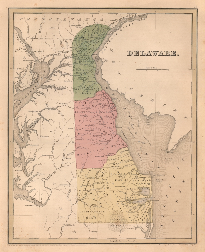
This is an 1838 Thomas G. Bradford map of Delaware. It is one of the few American atlas maps specifically of Delaware - most bundle it with either Maryland or New Jersey. Coverage embraces from the Susquehanna River and Chesapeake Bay to New Jersey and from Pennsylvania and New Jersey to Maryland and the Atlantic Ocean.
When construction began on the Chesapeake and Delaware Canal, business owners in New Castle, Delaware became concerned. They knew the new canal would pose a threat to their community and their businesses and knew that they needed to respond. They did so by chartering a railroad company. The New-Castle and Frenchtown Turnpike Company was chartered on January 24, 1809, in Delaware and soon after in Maryland and the company opened a turnpike in 1815 and 1816 from New Castle, Delaware, to Old Frenchtown Wharf, Maryland, on the Chesapeake Bay. The Maryland General Assembly authorized the company to replace the turnpike with a railroad in 1828 and change its name to the New-Castle and French Town Turnpike and Rail Road Company with similar laws passed in Delaware. The two separate companies in Maryland and Delaware merged in 1830, forming the New Castle and Frenchtown Turnpike and Rail Road Company and opened their new railroad in 1831. A series of mergers occurred in the following decades, as was very common with railroad companies. Today, parts of the original New-Castle and Frenchtown route are still operated by Norfolk Southern.
Transportation in 1840s Delaware
A common feature of maps published in A Universal Illustrated Atlas is their focus on transportation networks. Here, the Chesapeake and Delaware Canal and the New Castle and Frenchtown Turnpike and Railroad are featured. The Chesapeake and Delaware Canal, which connects the Delaware River and the Chesapeake Bay, opened in 1829, decades after the Chesapeake and Delaware Canal Company was incorporated in 1802. The canal runs 14 miles from Delaware City to the Elk River. Several setbacks, disputes, and other scandals hindered construction, but the project was finally completed. The canal remains in use and is operated by the U.S. Army Corps of Engineers. It provides a vital link in North Atlantic trade routes and millions of tons of cargo are transported annually through the canal.When construction began on the Chesapeake and Delaware Canal, business owners in New Castle, Delaware became concerned. They knew the new canal would pose a threat to their community and their businesses and knew that they needed to respond. They did so by chartering a railroad company. The New-Castle and Frenchtown Turnpike Company was chartered on January 24, 1809, in Delaware and soon after in Maryland and the company opened a turnpike in 1815 and 1816 from New Castle, Delaware, to Old Frenchtown Wharf, Maryland, on the Chesapeake Bay. The Maryland General Assembly authorized the company to replace the turnpike with a railroad in 1828 and change its name to the New-Castle and French Town Turnpike and Rail Road Company with similar laws passed in Delaware. The two separate companies in Maryland and Delaware merged in 1830, forming the New Castle and Frenchtown Turnpike and Rail Road Company and opened their new railroad in 1831. A series of mergers occurred in the following decades, as was very common with railroad companies. Today, parts of the original New-Castle and Frenchtown route are still operated by Norfolk Southern.
Publication History and Census
This map was engraved by George Boynton and published in the 1841 edition of Bradford and Goodrich's A Universal Illustrated Atlas. It is based upon an earlier map drawn by Lucas Fielding. The map received regular updates through the late 1840s.CartographerS
Thomas Gamaliel Bradford (1802 - 1887) was born in Boston, Massachusetts, where he worked as an assistant editor for the Encyclopedia Americana. Bradford's first major cartographic work was his revision and subsequent republishing of an important French geography by Adrian Balbi, Abrege de Geographie published in America as Atlas Designed to Illustrate the Abridgment of Universal Geography, Modern and Ancient. Afterwards Bradford revised and expanded this work into his own important contributions to American cartography, the 1838 An Illustrated Atlas Geographical, Statistical and Historical of the United States and Adjacent Countries. Bradford's cartographic work is significant as among the first to record Texas as an independent nation. In his long career as a map publisher Bradford worked with William Davis Ticknor of Boston, Freeman Hunt of New York, Charles De Silver of Philadelphia, John Hinton, George Washington Boynton, and others. We have been able to discover little of Bradford's personal life. More by this mapmaker...
Fielding Lucas Jr. (September 3, 1781 - March 12, 1854) was an American cartographer, chartmaker, and publisher active in Baltimore during the first half of the 19th century. Born in Fredericksburg, Virginia, little is known of Lucas's family and early life, but his lineage seems to have been established in Fredericksburg from at least the mid-1700s. Lucas founded Lucas Brothers, one of America's first stationers located at 116 East Baltimore Street, in 1804 and later, in 1806, he became the Baltimore manager of the Philadelphia based publishing firm Conrad, Lucas, and Company. Lucas is also known to have worked with the Matthew Carey firm in Philadelphia. Lucas entered the map trade around 1814, when he published an atlas of the United States - similar to, but in direct competition with, Matthew Carey, a matter which soured an otherwise profitable friendship. In 1825, Lucas also produced a world atlas. Over the course of his career, Lucas published several smaller atlases and numerous independent issue maps, including an important nautical chart of the Chesapeake and Delaware Bays. Many of his maps were engraved by H. S. Tanner, but he also worked with Robert Mills (Atlas of South Carolina) and others. Lucas attained considerable social prominence as a patron of the arts and philanthropist. He was a member of the committee that helped build Baltimore's Washington Monument and was one of the founding members of the Boston Harmonic Society and the Maryland Institute for the Promotion of Mechanical Arts. During the War of 1812, Lucas enlisted in Captain John Kanes' Company, 27th Maryland Regiment, although little is known of his actual service. From 1827 he served as a director of the Baltimore and Ohio Railroad and, later, as director of the Baltimore and Rappahannock Steam Packet Company. He died in Baltimore on March 12, 1854. (Foster, J. W., Fielding Lucas, Jr., Early 19th Century American Publisher of Fine Books and Maps, 'American Antiquarian Society', October 1955, Volume 64, Part 2, 162-212) Learn More...
George Washington Boynton (fl. c. 1830 - 1850) was a Boston based cartographer and map engraver active in the first half of the 19th century. Boynton engraved and compiled maps for numerous publishers including Thomas Bradford, Nathaniel Dearborn, Daniel Adams, and S. G. Goodrich. His most significant work is most likely his engraving of various maps for Bradford's Illustrated Atlas, Geographical, Statistical, and Historical, of the United States and the Adjacent Countries and Universal Illustrated Atlas. He also engraved for the Boston Almanac. In 1835, Boynton is listed as an employee of the Boston Bewick Company, an engraving, stereotype, and printing concern based at no. 47 Court Street, Boston. Little else is known of his life. Learn More...
Source
Bradford, T. G. and Goodrich, S. G., A Universal Illustrated Atlas, exhibiting a Geographical, Statistical, and Historical view of the World, (Boston: Charles D. Strong) 1841.
The Universal Illustrated Atlas is one of the great American atlases of the first half of the 19th century. The atlas was first published in 1838 under the imprint of Charles D. Strong. It replaced and superseded Bradford's earlier smaller format Illustrated Atlas, Geographical, Statistical, and Historical, of the United States and the Adjacent Countries. Numerous reissues of the Universal Illustrated Atlas followed until about 1848. Although there are minor variations between the editions, most contain about 50 maps, the majority of which focus on the United States. Bradford's atlases are significant for recording North America during the Republic of Texas Era. In later editions, particularly the 1846 edition, Bradford illustrates the boom in railroad construction, possibly with the idea that his maps would aid travelers in planning journeys by rail. It was compiled by Thomas Gamaliel Bradford and Samuel Griswold Goodrich with most of the plates engraved by George Washington Boynton (fl. c. 1830 - 1850). Other contributors include Thomas Gordon (1778 - 1848), Fielding Lucas Jr. (1781 - 1854), Samuel Edward Stiles (1844 - 1901), Sherman and Smith (fl. c. 1829 - 1855), and Horace Thayer (1811 - c. 1874).
Condition
Very good. Even overall toning. Light foxing.
References
Rumsey 0089.022.