
1585 Braun and Hogenberg / Marcus Jordanus Map of Denmark: First by a Dane!

This item has been sold.
Danorum Marca, vel Cimbricum, aut Daniae Regnum...
Earliest Acquirable Map of Denmark based on a Danish Source.
- Digital Map Information
- Suitable for large format printing
- Full resolution TIFF file
- ICC color profile embedded
- Delivered instantly via download link
Earliest Acquirable Map of Denmark based on a Danish Source.
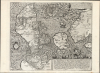
This is a superb example of Marcus Jordan's map of Denmark. Printed in 1588 by Georg Braun and Franz Hogenberg, it is the only map to be included in their eight-volume city atlas (as distinct from the work's abundant city plans and views). It is the first full-sheet printed map of Denmark, and is the earliest surviving printed map of Denmark produced from Danish sources. For collectors of Denmark, it is an essential and scarce work.A Closer Look
This intricately-engraved map captures Denmark, Fionia, and Schleswig-Holstein when the kingdom included Scania in what is now southern Sweden. It reaches as far east as Västergötland and Småland in Sweden; it spans from the tip of Jutland in the north to Hamburg and the Elbe River in the south. The map's detail is best in Schleswig-Holstein, Funen, and central Jutland. The waters of the Baltic and the North Sea are vigorously and dramatically engraved, particularly to the north, where the sea is churned by two mighty sea monsters (to the right of the arms of King Frederick II of Denmark, top center).First Surviving Printed Map of Denmark by a Dane
This map would likely be thought anonymous, were it not for the surviving correspondence of Danish cartographer Marcus Jordanus, which recorded that Jordanus had been asked by his patron Heinrich Rantzau (1526 - 1598) to produce a map of Denmark for inclusion in Braun and Hogenberg's Civitates Orbis Terrarum. Rantzau - governor of the Duchy of Holstein, humanist writer, and book collector - was Jordanus' patron as far back as 1580, when the mapmaker produced a map of Holstein dedicated to him. Rantzau would have been aware that Jordanus had produced a 1552 map (now lost) of Denmark for King Christian III. Rantzau was also a probable patron and a vital contributor to Braun and Hogenberg. He supplied no fewer than 40 city views for inclusion in that massive work - mostly from Schleswig-Holstein but also from Denmark and Scandinavia - so his connection with Braun and Hogenberg was fruitful, well worthy of a dramatic dedication within the text.A Dedicatory Work
It is then perhaps unsurprising that while Jordan's name appears nowhere on it, that of Rantzau is everywhere. There is a formal dedication to Rantzau in the upper right, but the entire map can be construed as a dedicatory page to Heinrich Rantzau in particular, and the House of Rantzau generally. Four blocks of text in the body of the map pertain to the role of Rantzau's father in the Count's Feud (1534 -1536) on behalf of the King of Denmark. These include the bloody triumph of Johan Rantzau (1492 - 1565) over Skipper Clement's peasant rebellion against King Christian III, and Rantzau's equally bloody victory over Christian III's foes in the 1535 Battle of Øksnebjerg. In the lower right, a text description of the Kingdom of Denmark is embellished with an allegorical dedication to the house of Rantzau: the composition is surmounted with the Rantzau arms, which are flanked by the two great classical gods of war: to the left, Pallas Athena, the Greek goddess of wisdom; to the right, Mars, the Roman god of military power, courage and violence in battle (any similarity between Mars and the Johan Rantzau is almost certainly deliberate). Between these - under the Rantzau arms, and indeed under Mars' foot - crouches a cluster of bound and shackled prisoners labeled 'Clemens,' Another pointed reference to Johan Rantzau's 1534 victory over the peasant rebellion. To the right of Mars/Johan are displayed spears, cannon, and other arms in praise of the Rantzau military achievements. To the left of Pallas (commanding more space than Mars' military detritus) is a mighty pile of books, a pair of globes, astronomical instruments, a pen, and an inkwell: these are subtitled in Latin, 'The forest of Rantzau's poems and horoscopes.' These last celebrate Heinrich's scholarly achievements, with the allusion that at least in part, Braun and Hogenberg's work might be ranked among them.Publication History and Census
This map, drawn by Marcus Jordanus, was almost certainly engraved by Franz Hogenberg in 1585 for inclusion in the 1588 fourth volume of the Braun and Hogenberg Civitates orbis terrarum; it remained in later editions of the work. It is known to survive in two states: the present example is of the first state, which includes the printed date 1585; a second state removes the date. Thirteen examples are cataloged in institutional collections.Cartographers
Marcus Jordanus (1531 - 1595) was a Danish cartographer and mathematician. Born in Holstein, he does not appear in the historical record until 1550. That year found Jordanus, a master of arts and professor at the University of Copenhagen, teaching mathematics and geography. The close of the University that year, due to a plague outbreak, brought Jordanus a great opportunity: Denmark's King Christian III tasked him with producing a map of the kingdom. While it does not survive in any known copies, Ortelius noted its existence and that it had been printed in 1552. He went on to produce a 1559 map of Holstein, which both Gerard De Jode and Abraham Ortelius copy for their atlases. The only surviving map of Denmark derived from Jordanus was published in 1585 by Braun and Hogenberg; a dedicatory work to their shared patron Heinrich Rantzau, it would be the only geographical map to appear amongst the city plans and views of Civitates Orbis Terrarum. These maps of his homelands were produced along with religious works: His first map had been a map of the Holy Land; this work, which Karrow dates to c. 1550, survives in a single copy tipped into a Luther Bible; it was almost certainly a separate issue, as it appears in no other bound work. He also produced a map showing the Biblical voyages of Saint Paul. Further Details...
Georg Braun (1541 – March 10, 1622) was a German deacon, viewmaker, and typo-geographer based in Cologne. Along with Franz Hogenberg (1535 - 1590), Braun is best known for his publication of the highly influential city atlas Civitates Orbis Terrarum. The six volume work, with some 546 views, was published between 1572 and 1617 and intended a companion to Abraham Ortelius' Theatrum Orbis Terrarum - thus certain obvious stylistic similarities. In compiling the Civitates Braun took on the role of editor while most of the engraving work was completed by Franz Hogenberg. Braun died, as he was born, in Cologne. Further Details...
Franz Hogenberg (1535 - 1590), often called 'Master Franz,' was a Flemish engraver active in the late 16th century. Hogenberg was born in Mechelen, the son of Nicolas Hogenberg, where he trained under the cartographer H. Terbruggen. He later relocated to Antwerp where he achieved success as an engraver, working with Abraham Ortelius, Hieronymus Cock, and others. In 1568, his name appeared on the list of those banned from the Netherlands by the Duke of Alva, forcing his family to flee to London. There he engraved for Christopher Saxon's Atlas of England and Wales. By 1570 he emigrated to Germany settling in Cologne. In Cologne he married his second wife, Agnes Lomar, with whom he had six children. In 1579 the couple were briefly imprisoned for holding illicit secret religious meetings, but were released in short order. Along with German cleric George Braun (1541 – March 10, 1622), Hogenberg issued the highly influential city atlas Civitates Orbis Terrarum. The six volume work, with some 546 views, was published between 1572 and 1617 and intended a companion to Abraham Ortelius' Thatrum Orbis Terrarum - thus certain obvious stylistic similarities. In compiling the Civitates Hogenberg took on the role of engraver while most of the editing was left to Georg Braun. Hogenberg died in Cologne, Germany, before the Civitates was completed. After his death, Hogenberg's work was continued by his son, Abraham Hogenberg, who, under the direction of Agnes, his mother, took over his father's enterprise at just 20. Further Details...
Source
Braun, G. and Hogenberg, F., Civitatus Orbis Terrarum, (Cologne: Braun and Hogenberg) 1572.
Condition
Excellent. Two miniscule wormtracks at centerfold, else fine.
References
OCLC 159838051. Rumsey 12126.416 (state 2). Karrow, R., Mapmakers of the Sixteenth Century and Their Maps #45/5.