
1924 Gill 'Wonderground' Pictorial Map of London

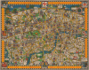

London The Heart of Britain's Empire Here Is Spread Out For Your View... / The Wonderground Map of London Town.
One of the Greatest Pictorial Maps Ever Produced.
- Digital Map Information
- Suitable for large format printing
- Full resolution TIFF file
- ICC color profile embedded
- Delivered instantly via download link
One of the Greatest Pictorial Maps Ever Produced.
This is Macdonald Gill's legendary Wonderground Map of London, England, here in the 1924 edition, issued in tandem with that year's British Empire Exhibition at Wembley. This outstanding and colorful pictorial map is credited with both 'saving the network' of the London Underground and inaugurating the Golden Age of Pictorial Cartography.A Closer Look
The map is loosely centered on Hyde Park Corner, from which it extends west to Kensington, east to Southwark, north to Camden Town, and south to Clapham Road. Underground stations are highlighted using the Underground's iconic red circle and blue bar banner. All around, the map highlights the fun to be had exploring London, including charming illustrations of Hyde Park, Kensington Gardens, Piccadilly Circus, fishing on the Thames, the Zoo at Regent's Park, and more. It also features historical commentary and local humor.Saving the Network
In 1914, the London Underground was in trouble. Used almost exclusively by rush-hour commuters, the Underground system was virtually abandoned on weekends, evenings, and holidays. The system depended upon income from greater ridership to support maintenance, repair, and expansion. Frank Pick, Commercial Manager for the Underground Electric Railways Company of London, realized that something had to be done. In addition to logistical improvements such as better punctuality, cleaner trains, and consistent service, Pick began an advertising campaign to increase off-peak ridership, for which this map was central. Pick reached out to Gerald T. Meynell of Westminster Press to produce a colorful poster illustrating the fun to be had via the Underground system. Meynell, in turn, contracted Macdonald Gill, whom he may have known from the Art Workers Guild, to complete the project. With its bright comic elements and cheerful design, the 'Wonderground Map' lightened the dour all-business image of the Underground, accomplishing its mission of inspiring off-peak travel.The Cartographic Significance of the Wonderground Map
Gill's map was and is very unusual, considering that it was intended to represent the Underground. Instead of stripping away details to help a traveler get from Point A to Point B, as with Harry Beck's renowned, utilitarian 1931 map of the London Underground, Gill crammed the canvas with vibrant color, vivid illustrations, visual puns, and text, including speech balloons, poems, and local inside jokes. Being heavily influenced by the Arts and Crafts movement, Gill drew on centuries-old cartographic traditions to create this work, and one can see echoes of Medieval maps, Braun and Hogenberg's late 16th-century city views (including their 'Londinum Feracissimi Angliae Regni Metropolis'), and ornate 17th and 18th-century maps with decorative borders. It is also somewhat reminiscent of contemporary fantasy maps such as Bernard Sleigh's 'Ancient Mappe of Fairyland' and Luxor Price's 'All Mother Goose Panorama' that can be seen as a form of escapism from the horrors of World War I and the difficult Interwar years. The rapid success of the Wonderground map sparked a global mapmaking phenomenon throughout the 1920s - 1930s, as artists far and wide copied Gill's formula of dense geography and decorative flourishes mixed with regional humor.The 1924 British Empire Exhibition
The 1924 British Empire Exhibition, held in Wembley, London, was a monumental colonial exhibition designed to stimulate trade, bolster imperial unity, and showcase the vast industrial and cultural resources of the British Empire in the wake of World War I. Opened by King George V (r. 1910 - 1936), the exposition served as a public relations campaign to reinforce the strength of the empire and celebrate modern technological progress. The vast site featured grand, purpose-built concrete pavilions representing various dominions and colonies, such as India, Canada, and Australia, alongside exhibition spaces like the Palace of Engineering and the Palace of Industry, which displayed the cutting edge of British manufacturing.Beyond its economic goals, the exhibition left a profound architectural and cultural legacy, most notably through the construction of the Empire Stadium, which would later become the world-famous Wembley Stadium. While the event ultimately incurred financial losses due to staggering construction costs and unpredictable British weather, it was an immense public spectacle, drawing over 27 million visitors across its 1924 run and subsequent reopening in 1925. It stood as the high-water mark of imperial pageantry, offering the public a highly idealized, encapsulated view of global British influence just as the geopolitical landscape of the empire was beginning to fundamentally shift.
Publication History and Census
This map was prepared by MacDonald 'Max' Gill for the London Underground and first published in 1914 by Westminster Press. There were several subsequent editions published between 1914 and 1928, most distinguished by minute changes to a triangle-shaped area in the upper left corner (between Chamberlayne Rd. and Harrow Rd.), resulting in at least five states. The original 1914 state only had houses in the triangle just mentioned. In 1915, a very large-format printing (50 inches wide) of the same map was issued. In 1922, a deviate state was printed with different text in the border. In 1924, a version (the present example) was issued for the 1924 British Empire Exhibition at Wembley, which included an Art Deco rendition of the British Imperial Lion in the triangle, along with a sign reading 'on to Wembley.' Another state was issued in late 1927 or early 1928, when a dog track opened at Wembley, where a greyhound replaced the British Lion. There are also slight color variations between the states.Since the various states are not dated, most examples of the map are cataloged as 1914, making a census of the different states in institutional collections nearly impossible. But three institutions, all in the U.K., do catalog the map with a suggested date of 1924: the National Library of Scotland, the University of Manchester, and the University of Cambridge.
Cartographers
Leslie MacDonald Gill (October 6, 1884 - January 14, 1947), known as 'Max Gill,' was a British cartographer, architect, and graphic designer. Known as MacDonald Gill or Max Gill, Gill was born in Brighton and was the younger brother of Eric Gill, a leading personality in the Arts and Crafts movement. Gill was educated at the Chichester Prebendal School, and the Holyrood School, and took classes in drawing and engraving at a local college. He began creating maps as a young map for map drawing competition in magazines. At 16, Gill was apprenticed as an architect to Leonard Pilkington. He relocated to London in 1903, where he worked for the ecclesiastical architectural firm of Sir Charles Nicholson and Hubert C. Corlette. While there, he attended meetings at the Art Workers Guild and attended classes at the Central School of Arts and Crafts. He went into business with his brother, Eric Gill, in 1908, doing architectural designs and murals. His first commercial map, a 'Wind-Dial' map for a gentlemanly estate in Buckinghamshire, was drawn in 1909. Gill is best known for his 1914 Wonderground Map, a pictorial map of the London Underground commissioned by Frank Pick, used to promote tourism among Londoners by using the Underground. He probably received the commission through is associate with Gerard Meynell of the Westminster Press. He is also known for multiple other pictorial maps and is credited with inaugurating the 'Golden Age of Pictorial Cartography.' Gill also designed the upper-case lettering used on headstones and war memorials by the Imperial War Graves Commission. Further Details...
Westminster Press (1921 - 1996) was a British publishing firm based in London. It was formed in 1921 by a group of newspaper interests associated with Liberal politics, namely the Joseph Rowntree Social Service Trust and the North of England Newspaper Company. Westminster Press received early and significant financial support from Weetman Pearson, 1st Viscount Cowdray (1856 - 1927), a grandee of Liberal political circles who had recently expanded his business interests into newspapers. The firm was named after the Liberal newspaper Westminster Gazette (owned by Pearson), which it merged with the Daily News to form the Daily News and Westminster Gazette. However, this paper was short-lived and for most of its history, the Westminster Press operated outside of London, consolidating provincial and local newspapers. It was one part of the larger S. Pearson and Son (later Pearson plc) publishing conglomerate, but was sold in 1996 to Newsquest, which was soon thereafter bought by Gannett (U.S.A. Today Co., Inc.). Further Details...
Condition
Good. Recornered with fill, upper left and right, top center, above London shield. Minor fill at a few fold points. Laid down on archival tissue.
References
OCLC 316455700. Burdon, Elizabeth. The Cartographic Impact of MacDonald Gill’s Wonderground Map of 1913. Unpub. Ms., the Newberry Library. Brown, K. and Hunt, S., Great City Plans, p. 194 - 195.