This item has been sold, but you can get on the Waitlist to be notified if another example becomes available.
1772 Robert de Vaugondy Set of Ten Maps for Diderot's Encyclopedia
DiderotSet-vaugondy-1772$1,750.00

Title
Carte des parties nord et oust de L'Amerique/ Carte des parties Nord et est de L'Asie/Nouvelle représentation Des Côtes Nord et Est de l'Asie/ Carte de la Californie et des Pays Nord-Ouest separés de l'Asie par le détroit d'Anian./ Carte de la Californie Suivant.../ Carte des Nouvelles Decouvertes dressée par Phil. Buache/ Carte Générale des Découvertes de l'Amiral de Fonte…/ Carte Generale des Découvertes de l'Amiral de Fonte ... Jefferys/ Carte qui Représente les différentes connoissances que l'on a eues des Terres Arctiques depuis 1650 jusqu'en 1747 / Partie de la Carte du Capitaine Cluny…
1772 (dated) 11.5 x 19.25 in (29.21 x 48.895 cm)
1772 (dated) 11.5 x 19.25 in (29.21 x 48.895 cm)
Description
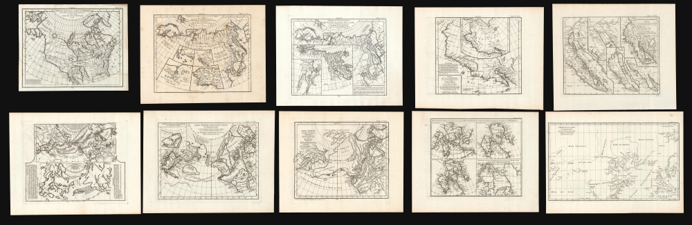
This is Robert de Vaugondy's seminal 1772 map series exploring the mapping of North America, Asia, and specifically the Northwest Passage, summarizing three centuries of cartography. Included as a supplement to Diderot's 1772 Encyclopédie, this was among the first studies in comparative cartography committed to print. The cartographic survey embraced some of the most important topics in 18th-century geography and might justifiably be proposed as the first cartobibliography.
Vaugondy's opening map presents North America, based on the scarce 1764/1765 Thomas Engel Carte du la Partie Septentrionale et Occidentale de l'Amerique (See Geograpicus: northamerica-engel-1764-2). This is a fascinating examination of the waterways of North America - especially in the west. Engel's map included the first depiction of the Columbia River, which is reflected here. Engel's work provided a baseline for Vaugondy to begin this map series.
The main map presents the assumed Northeast Passage, running from Scandinavia through the Strait of Anian to the Pacific. The map's four subordinate insets return to the question of the Americas. They are explicitly meant to accompany the previous map (a note in French reads These four supplements relate to the map of America indicated first.) Three of them derive from Cornelis Wytfliet's 1597 atlas of the Americas: his Granata Nova et California, Limes Occidentis Quiuira et Anian, and Conibas Regio. The first, however, is not from Wytfliet, including as it does the Isla de Plata north of Japan off the coast of 'Quivira.' The closest source we can find is Frans Hogenberg's 1589 Americae et Proximarum Regionum Orae Descriptio. All of these represented important precursors for mapping the American west coast.
This map focuses more closely on Siberia, Kamchatka, and the northeastern extremes of Asia, specifically as they relate to the possibilities of a Northeast Passage. This comparative map presents the state-of-the-art French cartography derived from J. N. De l'Isle and Philippe Buache's mapping of Asia, for example their Carte D'Asie dressee pour L'Instruction. Interesting features include an insular Iesso north of Japan, separated from the mainland by a 'Strait of Tessoy' (roughly corresponding to the Strait of Tartary). Thus, Iesso here can be understood as an early depiction of Sakahlin Island (rather than Hokkaido). The Kuril Islands are marked and named as well. Part of the northwest coast of North America is separated from Asia by a strait in which appears the island of Puchochotski, here spelled Puchochotsks. This crescent-shaped island resulted from the first depictions of Alaska based upon indigenous knowledge.
This is the first of Vaugondy's maps to focus specifically on the west coast of North America and includes two contrasting maps, both drawn from larger 17th-century maps. Vaugondy credits the primary map to a 1612 Visscher (likely the 1602 Claesz Americae Tabula Nova Multis, which survives only in later Visscher reissues) and the smaller derived from a Visscher printing of Plancius's world map. Vaugondy's object is to establish the state of the art of the mapping of the Pacific Coast at the beginning of the 17th century. Both maps span from below the Baja Peninsula to the Strait of Anian and the Anian Regnum. Both maps include the mythical kingdom of Quivira, Coronado's elusive city of gold, and both maps unequivocally portray Baja as a peninsula, and California solidly attached to the mainland.
This is the hotly-sought-after map recording the rise and fall of the 'California-as-an-island' myth. It is in the context of the prior map that this composite map of California makes the most sense. It details five signal European depictions of Baja California and the island of California, tracing both the precipitous 17th-century fall into the California-as-an-island myth and its laborious correction in the 18th century. The five maps presented here include the peninsular map of Italian cartographer Matheau Neron Pecci (1604) and the influential California as an island of Nicolas Sanson (1656). The third map, credited to Guillaume Delisle (1700), began walking back the error. The seminal Kino Map and a further Jesuit map (1705 and 1767 respectively) disproved the fallacy. Despite the authoritative Jesuit works referenced here, it was not until Cook's voyages that the controversy was put to rest.
The two contrasting maps on this sheet contend with sharply different models of the geography of the North Pacific: it compares the work of French Geographer Phillip Buache with that of Kaempfer's presentation of Japanese geography of the same region. The upper map, entitled 'Carte des Nouvelles Decouvertes' is a combination of data absconded from the Russian 'Academy of Sciences' by Joseph-Nicholas de L'Isle, and Philip Buache's speculations on the Northwest Passage.
The lower map is a rendition of an early Japanese map discovered by Englebert Kaempfer. Kaempfer was a German traveler who spent two years in Japan attached to the Dutch Embassy. When he returned to Europe, he brought the map of Japan and the Pacific Ocean, which Vaugondy recapitulated here. It presents Asia crudely, with only Japan displayed with relative accuracy (albeit oversized). This map does, nonetheless, include the Great Wall of China and Baja California - drawn with the hint of a Northwest Passage.
Having dispensed with one geographical phantom in the mapping of California as an island, here Vaugondy tackles two more myths: the Northwest Passage proposed by Joseph-Nicholas de L'Isle and Philip Buache in 1762 as the discovery of the fictional Bartholomew De Fonte, and Buache's speculative Sea of the West. Presenting a viable passage from Hudson Bay to the Pacific, these tantalizing cartographic fables would took the geographic world by storm until being ultimately put to rest by the voyages of Cook and La Perouse. This fanciful North American geography shares more authoritative depictions of the routes of important explorers of the Asian coastline, including Tchirikow, Frondat, and Bering, conferring the authority of the sublime upon the ridiculous.
It is a testament to the excitement surrounding the De Fonte geography that a second map in this series was dedicated to it. Vaugondy's source for this map was the 1768 map of British mapmaker Thomas Jefferys, who adopted the De Fonte legend wholeheartedly. Jeffery's map included an early depiction of Friedrich Muller's speculative peninsula (labeled as part of the land discovered by Russia). The Strait of Anian has here been replaced with the Detroit de Bering, the first appearance of that name in this series. The place name 'Anian' appears further south, adjacent to the legendary Chinese settlement of Fusang (扶桑), then a cause célèbre of European orientalists such as Joseph de Guignes, a contemporary of Robert de Vaugondy.
This sheet contrasts four delineations of Arctic Canada and Hudson Bay, focusing on the presumed Atlantic opening to a Northwest Passage. The four maps represent the North America of Nicolas Sanson (1650), two maps by Guillaume De L'Isle (1700 America and 1703 Canada, respectively), and the map of Henry Ellis (1747). Sanson's map, in the absence of actual exploration, presented a wealth of hopeful gaps in the coast of Buttons Bay and points north. The more circumspect De l'Isle gave in less to speculation in his North America, but his Canada contained enough tantalizing reports of western water routes to encourage the inclusion of the various passages appearing here. The last here, credited to Henry Ellis, who explored Hudson Bay in 1746-47, represents that decade's unsuccessful efforts funded by British politician Arthur Dobbs to prove that the Hudson Bay Company had been concealing a Northwest Passage via Hudson Bay. The map shows Wager Bay (discovered by Christopher Middleton in 1742 under Dobbs's patronage) along with the passage west via Wager Bay that Dobbs believed Middleton hid from him. Ellis' 1746-1747 voyage had been, in large part, intended to reveal Middleton's deception: Ellis' map was unable to contradict Middleton's, however.
The series ends with an unequivocal support of a northwest passage. The map extends from approximately 25° north to just beyond 80°; it reaches from the Muller Peninsula in the west to the coasts of Europe and Spitzbergen in the east. Its primary focus is a water passage running from Repulse Bay (at the north extreme of Hudson Bay) to an opening into the icy sea north of Canada and the Muller Peninsula. The map was drawn from the northern part of a map published by Captain Alexander Cluny in his 1769 The American Traveller. Cluny's work was an attack on the Hudson's Bay Company in the tradition of Arthur Dobbs, condemning their monopoly and suggesting that they might be hiding knowledge of a Northwest Passage to protect their business interests. Cluny included the invented passage on his map, naming its western outlet after the HBC's chief officers, Spurel and Fowler.
Geographic Puzzles in the Arctic
Geographers of the 17th and 18th centuries were puzzled over the possibilities of a northwest passage over North America, a northeast passage over Asia, the nature of the Pacific coasts of America and Asia, the insularity of California, the presence of a 'Sea of the West' in the American Pacific Northwest, and the nature of the island - or peninsula - found to the north of Japan. This group of maps provided the scholar with a compelling recapitulation of the best maps contending with these puzzles.Map 1
Carte des parties nord et oust de L'Amerique. (11.75 x 15 inches).Vaugondy's opening map presents North America, based on the scarce 1764/1765 Thomas Engel Carte du la Partie Septentrionale et Occidentale de l'Amerique (See Geograpicus: northamerica-engel-1764-2). This is a fascinating examination of the waterways of North America - especially in the west. Engel's map included the first depiction of the Columbia River, which is reflected here. Engel's work provided a baseline for Vaugondy to begin this map series.
Map 2
Carte des parties Nord et est de L'Asie. (11.5 x 14.5 inches.)The main map presents the assumed Northeast Passage, running from Scandinavia through the Strait of Anian to the Pacific. The map's four subordinate insets return to the question of the Americas. They are explicitly meant to accompany the previous map (a note in French reads These four supplements relate to the map of America indicated first.) Three of them derive from Cornelis Wytfliet's 1597 atlas of the Americas: his Granata Nova et California, Limes Occidentis Quiuira et Anian, and Conibas Regio. The first, however, is not from Wytfliet, including as it does the Isla de Plata north of Japan off the coast of 'Quivira.' The closest source we can find is Frans Hogenberg's 1589 Americae et Proximarum Regionum Orae Descriptio. All of these represented important precursors for mapping the American west coast.
Map 3
Nouvelle représentation Des Côtes Nord et Est de l'Asie. (11.5 x 14.25 inches).This map focuses more closely on Siberia, Kamchatka, and the northeastern extremes of Asia, specifically as they relate to the possibilities of a Northeast Passage. This comparative map presents the state-of-the-art French cartography derived from J. N. De l'Isle and Philippe Buache's mapping of Asia, for example their Carte D'Asie dressee pour L'Instruction. Interesting features include an insular Iesso north of Japan, separated from the mainland by a 'Strait of Tessoy' (roughly corresponding to the Strait of Tartary). Thus, Iesso here can be understood as an early depiction of Sakahlin Island (rather than Hokkaido). The Kuril Islands are marked and named as well. Part of the northwest coast of North America is separated from Asia by a strait in which appears the island of Puchochotski, here spelled Puchochotsks. This crescent-shaped island resulted from the first depictions of Alaska based upon indigenous knowledge.
Echoes of Strahlenberg
Both of the inset maps shown here derive from the work of the Swedish officer, linguist, cartographer, and hard-luck-case Philipp Johann von Strahlenberg, whose Russian captivity resulted in the earliest accurate mapping of Siberia and Russian Tartary. Inset No. I is credited to the map of the Tatar Empire appearing in the 1726 Histoire genéalogique des Tatars issued by Leyden publisher Kallewier (a work plagiarized from a map stolen from Strahlenberg in 1715). Inset No. II is from the 1725 map of Nuremberg mapmaker J. B. Homann, whose source was the 1718 map Strahlenberg produced to replace his stolen 1715 work.Map 4
Carte de la Californie et des Pays Nord-Ouest separés de l'Asie par le détroit d'Anian. (11.5 x 12.5 inches).This is the first of Vaugondy's maps to focus specifically on the west coast of North America and includes two contrasting maps, both drawn from larger 17th-century maps. Vaugondy credits the primary map to a 1612 Visscher (likely the 1602 Claesz Americae Tabula Nova Multis, which survives only in later Visscher reissues) and the smaller derived from a Visscher printing of Plancius's world map. Vaugondy's object is to establish the state of the art of the mapping of the Pacific Coast at the beginning of the 17th century. Both maps span from below the Baja Peninsula to the Strait of Anian and the Anian Regnum. Both maps include the mythical kingdom of Quivira, Coronado's elusive city of gold, and both maps unequivocally portray Baja as a peninsula, and California solidly attached to the mainland.
Map 5
Carte de la Californie Suivant... (11.75 x 14.25 inches).This is the hotly-sought-after map recording the rise and fall of the 'California-as-an-island' myth. It is in the context of the prior map that this composite map of California makes the most sense. It details five signal European depictions of Baja California and the island of California, tracing both the precipitous 17th-century fall into the California-as-an-island myth and its laborious correction in the 18th century. The five maps presented here include the peninsular map of Italian cartographer Matheau Neron Pecci (1604) and the influential California as an island of Nicolas Sanson (1656). The third map, credited to Guillaume Delisle (1700), began walking back the error. The seminal Kino Map and a further Jesuit map (1705 and 1767 respectively) disproved the fallacy. Despite the authoritative Jesuit works referenced here, it was not until Cook's voyages that the controversy was put to rest.
Map 6
Carte des Nouvelles Decouvertes dressée par Phil. Buache/ Extrait d'une Carte Japonoise de l'Univers… (11.5 x 14.5 inches).The two contrasting maps on this sheet contend with sharply different models of the geography of the North Pacific: it compares the work of French Geographer Phillip Buache with that of Kaempfer's presentation of Japanese geography of the same region. The upper map, entitled 'Carte des Nouvelles Decouvertes' is a combination of data absconded from the Russian 'Academy of Sciences' by Joseph-Nicholas de L'Isle, and Philip Buache's speculations on the Northwest Passage.
The lower map is a rendition of an early Japanese map discovered by Englebert Kaempfer. Kaempfer was a German traveler who spent two years in Japan attached to the Dutch Embassy. When he returned to Europe, he brought the map of Japan and the Pacific Ocean, which Vaugondy recapitulated here. It presents Asia crudely, with only Japan displayed with relative accuracy (albeit oversized). This map does, nonetheless, include the Great Wall of China and Baja California - drawn with the hint of a Northwest Passage.
Map 7
Carte Générale des Découvertes de l'Amiral de Fonte… (11.5 x 15 inches).Having dispensed with one geographical phantom in the mapping of California as an island, here Vaugondy tackles two more myths: the Northwest Passage proposed by Joseph-Nicholas de L'Isle and Philip Buache in 1762 as the discovery of the fictional Bartholomew De Fonte, and Buache's speculative Sea of the West. Presenting a viable passage from Hudson Bay to the Pacific, these tantalizing cartographic fables would took the geographic world by storm until being ultimately put to rest by the voyages of Cook and La Perouse. This fanciful North American geography shares more authoritative depictions of the routes of important explorers of the Asian coastline, including Tchirikow, Frondat, and Bering, conferring the authority of the sublime upon the ridiculous.
Map 8
Carte Generale des Découvertes de l'Amiral de Fonte (11.5 x 14 inches).It is a testament to the excitement surrounding the De Fonte geography that a second map in this series was dedicated to it. Vaugondy's source for this map was the 1768 map of British mapmaker Thomas Jefferys, who adopted the De Fonte legend wholeheartedly. Jeffery's map included an early depiction of Friedrich Muller's speculative peninsula (labeled as part of the land discovered by Russia). The Strait of Anian has here been replaced with the Detroit de Bering, the first appearance of that name in this series. The place name 'Anian' appears further south, adjacent to the legendary Chinese settlement of Fusang (扶桑), then a cause célèbre of European orientalists such as Joseph de Guignes, a contemporary of Robert de Vaugondy.
Map 9
Carte qui Représente les différentes connoissances que l'on a eues des Terres Arctiques depuis 1650 jusqu'en 1747 (11.5 x 13.5 inches).This sheet contrasts four delineations of Arctic Canada and Hudson Bay, focusing on the presumed Atlantic opening to a Northwest Passage. The four maps represent the North America of Nicolas Sanson (1650), two maps by Guillaume De L'Isle (1700 America and 1703 Canada, respectively), and the map of Henry Ellis (1747). Sanson's map, in the absence of actual exploration, presented a wealth of hopeful gaps in the coast of Buttons Bay and points north. The more circumspect De l'Isle gave in less to speculation in his North America, but his Canada contained enough tantalizing reports of western water routes to encourage the inclusion of the various passages appearing here. The last here, credited to Henry Ellis, who explored Hudson Bay in 1746-47, represents that decade's unsuccessful efforts funded by British politician Arthur Dobbs to prove that the Hudson Bay Company had been concealing a Northwest Passage via Hudson Bay. The map shows Wager Bay (discovered by Christopher Middleton in 1742 under Dobbs's patronage) along with the passage west via Wager Bay that Dobbs believed Middleton hid from him. Ellis' 1746-1747 voyage had been, in large part, intended to reveal Middleton's deception: Ellis' map was unable to contradict Middleton's, however.
Map 10
Partie de la Carte du Capitaine Cluny… (11.5 x 19.25 inches).The series ends with an unequivocal support of a northwest passage. The map extends from approximately 25° north to just beyond 80°; it reaches from the Muller Peninsula in the west to the coasts of Europe and Spitzbergen in the east. Its primary focus is a water passage running from Repulse Bay (at the north extreme of Hudson Bay) to an opening into the icy sea north of Canada and the Muller Peninsula. The map was drawn from the northern part of a map published by Captain Alexander Cluny in his 1769 The American Traveller. Cluny's work was an attack on the Hudson's Bay Company in the tradition of Arthur Dobbs, condemning their monopoly and suggesting that they might be hiding knowledge of a Northwest Passage to protect their business interests. Cluny included the invented passage on his map, naming its western outlet after the HBC's chief officers, Spurel and Fowler.
Publication History and Census
This set of ten maps was prepared by Vaugondy for the Supplement to Diderot's Encyclopédie. The Supplément à l'Encyclopédie is well represented in institutional collections. The separate maps appear on the market with some frequency, but assembled sets are more scarce.CartographerS
Robert de Vaugondy (fl. c. 1716 - 1786) was French may publishing from run by brothers Gilles (1688 - 1766) and Didier (c. 1723 - 1786) Robert de Vaugondy. They were map publishers, engravers, and cartographers active in Paris during the mid-18th century. The father and son team were the inheritors to the important Nicolas Sanson (1600 - 1667) cartographic firm whose stock supplied much of their initial material. Graduating from Sanson's maps, Gilles, and more particularly Didier, began to produce their own substantial corpus. The Vaugondys were well-respected for the detail and accuracy of their maps, for which they capitalized on the resources of 18th-century Paris to compile the most accurate and fantasy-free maps possible. The Vaugondys compiled each map based on their own geographic knowledge, scholarly research, journals of contemporary explorers and missionaries, and direct astronomical observation. Moreover, unlike many cartographers of this period, they took pains to reference their sources. Nevertheless, even in 18th-century Paris, geographical knowledge was limited - especially regarding those unexplored portions of the world, including the poles, the Pacific Northwest of America, and the interiors of Africa, Australia, and South America. In these areas, the Vaugondys, like their rivals De L'Isle and Buache, must be considered speculative or positivist geographers. Speculative geography was a genre of mapmaking that evolved in Europe, particularly Paris, in the middle to late 18th century. Cartographers in this genre would fill in unknown lands with theories based on their knowledge of cartography, personal geographical theories, and often dubious primary source material gathered by explorers. This approach, which attempted to use the known to validate the unknown, naturally engendered rivalries. Vaugondy's feuds with other cartographers, most specifically Phillipe Buache, resulted in numerous conflicting papers presented before the Academie des Sciences, of which both were members. The era of speculative cartography effectively ended with the late 18th-century explorations of Captain Cook, Jean Francois de Galaup de La Perouse, and George Vancouver. After Didier died, his maps were acquired by Jean-Baptiste Fortin, who in 1787 sold them to Charles-François Delamarche (1740 - 1817). While Delamarche prospered from the Vaugondy maps, he defrauded Vaugondy's window Marie Louise Rosalie Dangy of her rightful inheritance and may even have killed her. More by this mapmaker...
Denis Diderot (October 5, 1713 - July 31, 1784) was a French Enlightenment era philosopher, publisher and writer. Diderot was born in the city of Langres, France and educated at the Lycée Louis le Grand where, in 1732, he earned a master of arts degree in philosophy. Diderot briefly considered careers in the clergy and in law, but in the end chose the more fiscally challenge course of a writer. Though well respected in philosophical circles Diderot was unable to obtain any of the government commissions that commonly supported his set and consequently spent much of his life in deep poverty. He is best known for his role in editing and producing the Encyclopédie . The Encyclopédie was one of the most revolutionary and impressive works of its time. Initially commissioned as a translation of Ephraim Chambers' Cyclopaedia, or Universal Dictionary of Arts and Sciences, Diderot instead turned into a much larger and entirely new work of monumental depth and scope. Diderot's Encyclopédie was intended to lay bare before the common man the intellectual mysteries of science, art and philosophy. This revolutionary mission was strongly opposed by the powers of the time who considered a learned middle class it a threat to their authority. In the course of the Encyclopédie production Diderot was imprisoned twice and the work itself was officially banned. Nonetheless, publication continued in response to a demand exceeding 4000 subscribers. The Encyclopédie was finally published in 1772 in 27 volumes. Following the publication of the Encyclopédie Diderot grew in fame but not in wealth. When the time came to dower his only surviving daughter, Angelique, Diderot could find no recourse save to sell his treasured library. In a move of largess, Catherine the II Russia sent an emissary to purchased the entire library on the condition that Diderot retain it in his possession and act as her "librarian" until she required it. When Diderot died of gastro-intestinal problems 1784, his heirs promptly sent his vast library to Catherine II who had it deposited at the Russian National Library, where it resides to this day. Learn More...
Source
Diderot, D., Encyclopédie, ou dictionnaire raisonné des sciences, des arts et des métiers, Supplement, (Paris) 1772.
Condition
Very good. Ten maps; measurement given is for sheet 10. Few light stains to second sheet. Left margin extended on first sheet with a slight mend at insertion point.
References
Rumsey 10402.000. Wagner, H. R., Cartography of the Northwest Coast of America, #637 McLaughlin, G., The Mapping of California as an Island, #241 (Sheet 5 only).