This item has been sold, but you can get on the Waitlist to be notified if another example becomes available, or purchase a digital scan.
1737 Homann Heirs Map of New England, Georgia and Carolina, and Virginia and Maryland
DominiaAnglorum-hmhr-1737$800.00

Title
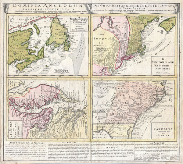
Dominia Anglorum in America Septentrionali. Specialibus Mappis Londini Primum a Mollio Edita, Nunc Recusa ab Homannianis Hered.
c. 1737 (undated) 19.5 x 21.5 in (49.53 x 54.61 cm)
c. 1737 (undated) 19.5 x 21.5 in (49.53 x 54.61 cm)
Description
A spectacular example of the Homan Heirs 1737 map of the British Territories in North America. Divided into four separate maps derived from the work of Herman Moll. Covers much of the eastern coast of North America including Nova Scotia & Newfoundland, New England (New York, New Jersey, Massachusetts, Pennsylvania, etc..), Virginia & Maryland, and Carolina ( now North Carolina, South Carolina, Georgia) and northern Florida. The upper left quadrant features a map of the Maritime Provinces of Newfoundland and Nova Scotia. Offers wonderful detail both inland and offshore, with special attention to the shoals. Upper right hand quadrant features much of New England, New York and parts of Pennsylvania and New Jersey. The Jerseys are shown spit into eastern and western provinces according to their original charters. New York extends northward past Lake Champlain, which is itself set significantly south and west of its actual location. Notes Albany. Lower left quadrant features a map of those parts of Virginia and Maryland adjoining the Chesapeake Bay. Lower right quadrant features much of what is today North Carolina, South Carolina, Georgia, Alabama and Northern Florida. Notes land dispute with the Spanish territories with regard to the rights to Northern Florida, referencing various charters to the Carolinas. Predates Georgia. Excellent detail both inland and along the coast. Bounded on the western end by the Appalachian Mountains. Below the map is a large text area with notations on the land and peoples depicted, including a special commentary dedicated to the Iroquois Nation.
CartographerS
Johann Baptist Homann (March 20, 1664 - July 1, 1724) was the most prominent and prolific map publisher of the 18th century. Homann was born in Oberkammlach, a small town near Kammlach, Bavaria, Germany. As a young man, Homann studied in a Jesuit school and nursed ambitions of becoming a Dominican priest. Nonetheless, he converted to Protestantism in 1687, when he was 23. It is not clear where he mastered engraving, but we believe it may have been in Amsterdam. Homann's earliest work we have identified is about 1689, and already exhibits a high degree of mastery. Around 1691, Homann moved to Nuremberg and registered as a notary. By this time, he was already making maps, and very good ones at that. He produced a map of the environs of Nürnberg in 1691/92, which suggests he was already a master engraver. Around 1693, Homann briefly relocated to Vienna, where he lived and studied printing and copper plate engraving until 1695. Until 1702, he worked in Nuremberg in the map trade under Jacob von Sandrart (1630 - 1708) and then David Funck (1642 - 1709). Afterward, he returned to Nuremberg, where, in 1702, he founded the commercial publishing firm that would bear his name. In the next five years, Homann produced hundreds of maps and developed a distinctive style characterized by heavy, detailed engraving, elaborate allegorical cartouche work, and vivid hand color. Due to the lower cost of printing in Germany, the Homann firm could undercut the dominant French and Dutch publishing houses while matching their diversity and quality. Despite copious output, Homann did not release his first major atlas until the 33-map Neuer Atlas of 1707, followed by a 60-map edition of 1710. By 1715, Homann's rising star caught the attention of the Holy Roman Emperor Charles VI, who appointed him Imperial Cartographer. In the same year, he was also appointed a member of the Royal Academy of Sciences in Berlin. Homann's prestigious title came with several significant advantages, including access to the most up-to-date cartographic information as well as the 'Privilege'. The Privilege was a type of early copyright offered to very few by the Holy Roman Emperor. Though less sophisticated than modern copyright legislation, the Privilege offered limited protection for several years. Most all J. B. Homann maps printed between 1715 and 1730 bear the inscription 'Cum Priviligio' or some variation. Following Homann's death in 1724, the firm's map plates and management passed to his son, Johann Christoph Homann (1703 - 1730). J. C. Homann, perhaps realizing that he would not long survive his father, stipulated in his will that the company would be inherited by his two head managers, Johann Georg Ebersberger (1695 - 1760) and Johann Michael Franz (1700 - 1761), and that it would publish only under the name 'Homann Heirs'. This designation, in various forms (Homannsche Heirs, Heritiers de Homann, Lat Homannianos Herod, Homannschen Erben, etc.) appears on maps from about 1731 onwards. The firm continued to publish maps in ever-diminishing quantities until the death of its last owner, Christoph Franz Fembo (1781 - 1848). More by this mapmaker...
Herman Moll (1654 - 1732) was an important 18th century map publisher and engraver based in London and Holland. Moll's origins are disputed with some suggesting he was born in the Netherlands and others Germany - the Moll name was common in both countries during this period. Most likely Moll was a German from Bremen, as his will, friends, and contemporaries suggest. What is known for certain is that he moved to London in 1678, possibly fleeing the Scanian War, where he worked as an engraver for Moses Pitt and other London map publishers. Around the turn of the century, Moll set up his own shop where he produced a large corpus of work known for its high quality and decorative flair. As a new émigré to England, Moll made himself more English than the English, and through his cartography proved a fierce advocate for his adopted nation. Most of Moll's early maps were issued as loose sheets that would be bound to order, however, he did publish several important atlases late in his career. Moll is said to have made the bold claim that without a doubt "California is an Island" and that he "had in [his] office mariners who have sailed round it." While California may not be an island (yet), it is true that moll had talent for attracting interesting friends and acquaintances. He frequented London's first stock exchange, Jonathan's Coffeehouse at Number 20 Exchange Alley, Cornhill. At the time Jonathan's was known as "a place of very considerable concourse for Merchants, sea faring Men and other traders" (Erleigh, The Viscount, The South Sea Bubble, Manchester: Peter Davies, Ltd., 1933, 21). Eventually this activity attracted the interest of stock brokers, who inspired by sailor's tales, sponsored the ill-fated South Sea Company, the world's first stock bubble. Moll's close circle, mostly from the Coffee House, included scientist Robert Hooke, the writers Daniel Defoe (Robinson Crusoe) and Jonathan Swift (Gulliver's Travels), the pirates William Dampier, William Hacke and Woodes Rogers, and the archeologist William Stukeley. Herman Moll's work was highly regarded for its decorative beauty and was pirated, most notably by the Irish publisher George Grierson, both in his lifetime and after his 1732 death at St. Clement Danes, London. Learn More...
Condition
Very good condition. Minor water stain to lower left and right corners. Blank on verso. Original platemark visible.
References
Cumming, William P., The Southeast in Early Maps, #233. Van Ermen, Eduard, The United States in Old Maps and Prints, p. 70-1. McCordle, Barbara B., New England in Early Printed Maps 1513-1800: An Illustrated Carto-Bibliography, 740.1. Sellers, John R. and Van Ee, Patricia Molen, Maps and Charts of North America and the West Indies 1750-1789, 83. Lowery, Woodbury, The Lowery Collection: A Descriptive List of Maps of the Spanish Possessions within the Present Limits of the United States, 1502- 1820, 359. Portinaro, Pierluigi, and Franco Knirsch, The Cartography of North America: 1500-1800, CXXIII. Phillips, P.L. (Atlases) 586, #148.