This item has been sold, but you can get on the Waitlist to be notified if another example becomes available, or purchase a digital scan.
1921 Bureau of Soils Map of Duval County, Florida
DuvalCountyFL-bureausoils-1921$200.00

Title
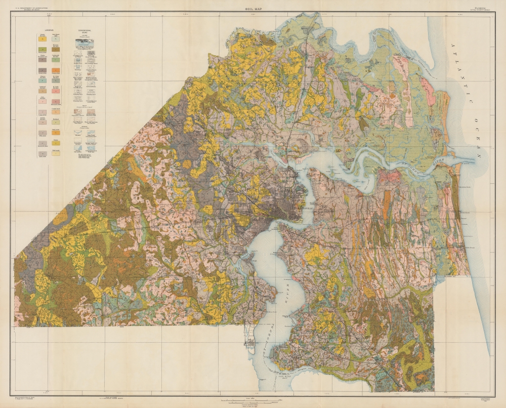
Soil map, Florida, Duval County sheet.
1921 (dated) 35 x 43.5 in (88.9 x 110.49 cm) 1 : 62500
1921 (dated) 35 x 43.5 in (88.9 x 110.49 cm) 1 : 62500
Description
A scarce 1921 soil map of Duval County, Florida, produced by the U.S. Department of Agriculture's Bureau of Soils. It was published at the start of the Florida Land Boom, when Jacksonville was dubbed the 'Gateway to Florida' for tourists and migrants from northern states.
A Closer Look
The entirety of Duval County is displayed, with Jacksonville at center and the St. Johns River weaving through the county before emptying into the Atlantic Ocean. A variety of soil types, mostly sandy, are represented in brilliant color, corresponding to a legend at left. Roads (including the Dixie Highway), railroads (including the Florida East Coast Railroad), mines, bridges, administrative boundaries, elevation, and waterways are also indicated as noted at left.Florida Land Boom
Jacksonville was emblematic of Florida as a whole in trying to position itself as a tropical retreat for wealthy northerners in the late 19th and early 20th century. After achieving some success in this regard in the 1880s, the city's reputation took a hit with repeated Yellow Fever outbreaks. In the 1910s, the city was able to attract motion picture companies looking for a convenient warm weather location to shoot films. Then, in the 1920s, Jacksonville saw an influx of capital and people, aided by the transportation links provided by the Dixie Highway and the Florida East Coast Railroad. Even though most tourists and migrants only passed through Jacksonville on their way to destinations further south, the city still benefitted economically, and new development increased accordingly. The precise accounting of the soils around the county provided by this map would have been invaluable for construction and urban planning purposes.Publication History and Census
This map was published in 1921 by the Bureau of Soils, with Arthur E. Taylor and T.J. Dunnewald conducting surveys which were applied to a base map produced by the U.S. Geological Survey. It is held by Brigham Young University, the University of Wisconsin-Milwaukee, the University of Chicago, Lake Superior State University, the Jacksonville Public Library, the University of North Florida, the University of Central Florida, and the University of Alabama.CartographerS
August Hoen and Company (fl. c. 1840 - 1981) was a Baltimore based engraving and lithography firm active in the middle part of the 19th century. A. Hoen and Co. was originally founded by Edward Weber under the name 'E. Weber and Company.' Weber died in the early 1850s and his company was taken over by German immigrant August Hoen (18?? - 1886) and his brothers, Henry and Ernest Hoen. As general interest lithographers, the Hoen firm's corpus includes posters, cigar boxes, sheet music covers, and posters as well as maps. They are best known for their pioneering multi-color lithographic techniques. After the death of August Hoen, the business passed on to his son, Albert Hoen. Another son, Earnest A. Hoen, moved to Richmond, Virginia and opened a branch of the firm there where he was granted a charter to produce Civil War era Confederate Currency. Their contributions to the cartographic field are generally in association with engraving and printing work done for Jacob Monk and the U.S. Geological Survey. The Hoen family maintained an active interest in the firm for the next 100 years or so until it finally filed for bankruptcy in 1981. More by this mapmaker...
The United States Geological Survey (1878 - Present), aka the U.S.G.S., is a scientific agency of the United States government, which was founded in 1879. USGS scientists study the landscape of the United States, its natural resources, and the natural hazards that threaten it. The organization has four major science disciplines: biology, geography, geology, and hydrology. It is a bureau of the United States Department of the Interior and is the department's only scientific agency. Learn More...
Condition
Very good. Minor wear at fold intersections. Closed repairs on verso along fold separations in margin.
References
OCLC 69247012, 1342406979.