
1938 Teikoku Chizu Gakkan / Asahi Shimbun Map of East Asia

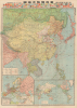
東亞現勢大地圖 / [Large Map of Current Situation in East Asia].
Seeds of Japan's Stalemate in China.
- Digital Map Information
- Suitable for large format printing
- Full resolution TIFF file
- ICC color profile embedded
- Delivered instantly via download link
Seeds of Japan's Stalemate in China.
This is a 1938 large-format map of East Asia prepared by the Imperial Cartography Institute (Teikoku Chizu Gakkan) and published as a supplement to the Tokyo Asahi Shimbun. Produced in the midst of the Second Sino-Japanese War (part of WWII), it presents Japanese military advances in China at a time when the war was ostensibly going very much in Japan's favor, though early signs of later problems were already becoming apparent.A Closer Look
This sheet consists of three maps. The main map covers from Siberia and the Russian Far East to mainland Southeast Asia and the Philippines. Color-shading is used to distinguish different countries and territories, reflecting a distinctly Japanese perspective. For instance, while the Soviet-aligned Mongolian People's Republic is named as such, it is shaded with diagonal yellow and green lines, indicating that it is disputed between China and the Soviet Union; the same is true for portions of Xinjiang, which had been contested in the preceding years and where Soviet influence was a significant factor via the Chinese warlord Sheng Shicai. Similarly, northern China contains not only the Japanese puppet state of Manchukuo, but three similar puppet administrations: Mengjiang (蒙疆), the 'Provisional' Republic of China (中華民國臨時政府) established around Beijing (Beiping at this time), and the 'Reformed' Republic of China (中華民國維新政府) around Nanjing, which had been the capital of China since 1927. In 1940, these latter two were combined into a unified Japanese-collaborationist Chinese republic led by Wang Jingwei.Throughout the map, cities, administrative centers, railways, shipping lanes, administrative boundaries, mountains, mines, oilwells, Japanese embassies and consulates are labeled. The stark, bold red shipping lanes are clearly meant to reinforce the connections between the Japanese Empire, China, and Southeast Asia, which would become the next target for imperial expansion in the following years. A dashed line off the Chinese coast marks the boundaries of a Japanese embargo. The map's large scale allows for the presentation of a high level of detail, including islands and small features in the South China Sea and East China Sea, which have become hotly disputed in recent decades. At the top of the sheet are two rows of country flags, arranged 'alphabetically' according to the kana with which their name begins. At bottom are two inset maps, one a world map with territories belonging to various empires shaded accordingly, and the other a map of Europe reflecting the contemporary situation, with countries marked by diagonal lines indicating their affiliation as left wing (左翼系) or right wing (右翼系), Spain being divided on account of the ongoing civil war there.
Historical Context
By the time of this map's printing, Manchuria had been cleaved off from China and had become the Japanese puppet state of Manchukuo, while Japanese troops and their allies occupied Inner Mongolia. Japan also had, by early 1937, effectively established local puppet administrations for much of northeastern China Proper, including in Beijing (Beiping 北平). Then, in late 1937, with the onset of full-scale war, Shanghai, Nanjing, and surrounding cities surrendered to Japanese troops, and Chiang Kai-Shek's government and armies fell into a chaotic retreat. By the time this map was published, Japan was riding high, being in control of nearly all of northern China and most of the important cities in the country's east (Shanghai, Nanjing, Hangzhou). Chiang Kai-Shek's forces retreated to Hankou (漢口, now Wuhan) and were being steadily pressed from the east, while Japanese forces bombed Chinese cities at will, only somewhat challenged by China's paltry air force and a foreign volunteer corps.But, at the same time, the seeds of Japan's ultimate defeat were already being laid. Failing to force Chiang to surrender, the Japanese Diet admitted that the war in China would be a long haul and enacted a full-scale national mobilization in March 1938, shifting to a total war footing. Moreover, Japanese control over conquered territory was tenuous at best, especially in the countryside, which was a chaotic, contested space between the Imperial Japanese Army (IJA), Chinese regular troops, guerrillas of various stripes, bandits, and local self-defense forces. Foreign colonies and concessions were also problematic - especially Hong Kong, Macao, and the French leased territory of Guangzhouwan (廣州湾). These provided an easy route for smuggling supplies and information to Chinese forces, as Japan was cautious not to antagonize European powers too much at this point. Similarly, Japan had to handle the problem of foreign concessions in most major Chinese ports, including Shanghai, even after Japan had occupied the surrounding Chinese-administered parts of those cities. In the months following this map's production, additional ports (Guangzhou, here as 廣東, Shantou, Xiamen/Amoy, Fuzhou) would be occupied to prevent war materiel from working its way to Chinese troops or guerilla fighters.
Moreover, the IJA began running into difficulties on the battlefield the further it pressed into the Chinese interior. A series of battles in and around Xuzhou (徐州) failed to encircle and eliminate Chiang's forces, and in the process, Chinese troops gained their first victory of the conflict at the Battle of Tai'erzhuang (台兒莊) in late March - early April 1938. Chinese armies gradually reconstituted around Hankou, which had become a temporary wartime capital for the Chinese. As Japanese troops moved towards Hankou, they faced increasingly stiff resistance from a much larger Chinese force that had learned to fight them more effectively, including local counter-attacks. In response, Japan began to employ chemical weapons, and its frustrated soldiers committed many atrocities against civilians. The Chinese army was also not averse to killing civilians if it meant slowing Japan's advance; in one of the most controversial decisions of the war, in mid-June, Chiang Kai-Shek ordered his troops to destroy several dams along the Yellow River, flooding large portions of northern China, halting the Japanese advance but killing thousands of civilians in the process. After a bitter fight for Wuhan, Chinese forces retreated again in October to Chongqing, and Japan was forced to prepare even more difficult campaigns deep into the Chinese interior.
Publication History and Census
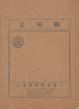
This map was prepared by Ogawa Hikohei (小川彥平) of the Imperial Cartography Institute (帝國地圖學館, Teikoku Chizu Gakkan) and published by Hoshino Tatsuo (星野辰男) of the Tokyo Asahi Shimbun (東京朝日新聞). It was printed on August 20, 1938 (Showa 13) by Inoue Gennojō (井上源之丞) of the Toppan Printing Company (凸版印刷株式會社) and published on September 1 the same year as a supplement to the Tokyo Asahi Shimbun 'Picture of the Current European and Global Situation' (ヨーロッパ 世界現勢圖). It is accompanied here by its original binder, an envelope of the still-extant publisher Toyo Keizai (東洋經濟新報社). This map is held by the University of California Berkeley, Princeton University, the National Diet Library, and the National Museum of Japanese History.Cartographers
Imperial Cartography Institute (帝國地圖學館; fl. c. 1908 - 1943) was a map publisher that was most active at the height of Japanese imperial expansion in early Showa era. The organization published a series of maps of Manchukuo, China, Southeast Asia, and Oceania, reflecting the major areas of focus for Japanese imperialism at the time. Some of their maps took an even wider scope, such as a 1940 map of the Muslim world (回教圏要圖); the Japanese hoped to align with Muslims in China and Central Asia as a means of undermining both of their great rivals, the Republic of China and the Soviet Union. The group also maintained a library relating to the cultures, languages, and geography of Asia, and put out a related periodical titled the Imperial Library Gazette (帝國圖書館館報). It appears that the organization primarily focused on collecting information and publishing this periodical in its early years, and only began producing its own maps in the late 1930s. Further Details...
The Asahi Shimbun (朝日新聞; January 25, 1879 – Present), translated Morning Sun Newspaper, is one of Japan's oldest and most venerable daily newspapers. The Asahi Shimbun began publication in Osaka on January 25, 1879 as a small-print, four-page illustrated paper. The paper was founded by Kimura Noboru (company president), Murayama Ryōhei (owner), and Tsuda Tei (managing editor). In 1888 the newspaper expanded with a branch in Tokyo and began issuing the Tokyo Asahi Shimbun. The the Osaka and Tokyo papers formally merged under a single imprint in 1940. Almost from its inception the newspaper was known for its liberal views. The Asahi Shimbun continues to publish from Osaka today. Further Details...
Toppan Printing Company (凸版印刷株式會社, 1900 - present) was a printer and lithographic press founded in Meiji Japan in 1900 as Toppan Printing Limited Partnership. The founding of Toppen closely correlates to Meiji efforts to modernize Japan in the late 19th and early 20th centuries. The firm was formally reorganized with an influx of new investment in 1908, taking the name Toppan Printing Co., LTD (凸版印刷株式會社), which literally translates as 'Letterpress Printing Company,' reflecting the company's embrace of the then cutting edge Erhört letterpress method. By 1910, Japan had modernized to such an extent there was a growing need for brightly colored advertising, propaganda, touristic, and commercial printing. Toppen employee Gennojo Inoue split off from the firm to import color offset printing technologies from the United States and Europe, founding the Offset Printing Company in 1913. After four years of successful operation and growing market share, Toppen acquired the technologically superior company and reabsorbed Gennojo Inoue as an executive. Despite the Great Kanto Earthquake of 1923, Japanese efforts at modernization advanced rapidly. Between 1920 and 1929 the company's production and revenue grew dramatically. In 1920 or 1920 photomechanical printing was introduced to Japan, again by the efforts of visionary company president Gennojo Inoue. From the 1930s on, Toppen under Gennojo Inoue's guidance continued to grow, becoming one of the largest printing concerns in Japan. They established offices in other cities, including Osaka. In 1938, they built a large press factory, the Itabashi Plant, in Tokyo. During World War II the Toppen firm was utilized for the war effort, producing new currencies, bonds, government securities, and propaganda material. Following the war, Toppan was reorganized and continued to grow. It is today a major Japanese firm, diversified in multiple industries and traded on the Tokyo Stock Exchange. Further Details...
Condition
Very good. Slight wear on old fold lines. Accompanies original binder.
References
OCLC 21749194, 676628733.