1862 Nicholson Civil War Map of Virginia and Maryland
EasternVirginia-nicholson-1862$2,000.00

Title
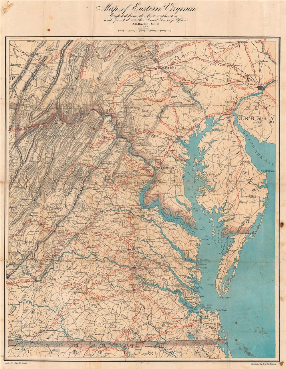
Map of Eastern Virginia.
1862 (dated) 24.75 x 19 in (62.865 x 48.26 cm) 1 : 894080
1862 (dated) 24.75 x 19 in (62.865 x 48.26 cm) 1 : 894080
Description
This is an 1862 Walter L. Nicholson map of eastern Virginia and Maryland, published during the second year of the American Civil War (1861 - 1865). The map embraces the Eastern Theater of war, from Pennsylvania south to the North Carolina - Virginia border. Washington, D.C. stands out on the Potomac River, while red concentric circles in ten mile increments focus upon Richmond. No battlefields are explicitly marked, but landmarks for which battles were named both before and after this map was published, including Fredericksburg, Chancellorsville, Spotsylvania Court House, and Gettysburg, appear. Red overprinting illustrates the railroad network, which proved critical to both the Union and Confederate war effort. Both sides used the railroads to move men and supplies to and from battlefields. Railroads and railroad hubs thus became strategic targets for raids and advancing armies.
Publication History and Census
This map was compiled by Walter L. Nicholson, lithographed by Charles G. Krebs, and printed by the United States Coast Survey during the superintendency of A.D. Bache. This map is well represented in institutional collections. However, it is scarce on the private market, and we note only a handful of instances when it has appeared in recent years.CartographerS
Walter Lamb Nicholson (April 27, 1825 - April 13, 1895) was a topographer working with the United States Postal Service in the second half of the 19th century. Nicholson was born in Edinburgh, Scotland, where he trained as a civil engineer. He emigrated to the United States in 1856, registered for the draft in the American Civil War (1861 - 1865) in 1863, and naturalized as U.S. Citizen in 1873. By 1860 he was working in Washington D.C. as a lithographer with the U.S. Coast Survey, where he introduced photolithographic technology. On July 15, 1861, he transitioned to the Postal Department, where he succeeded Henry A. Burr (1809 - 1863) as official 'Topographer'. He issued numerous important postal route maps from about 1866 to his retirement in 1887. His postal maps continued to be used and updated by subsequent Postal Topographers until about 1900. More by this mapmaker...
Charles G. Krebs (1830 - 1890) was a German American lithographer and engraver. Born in Germany, Charles was living in Washington, D.C. working for the U.S. Coast Survey by 1862. When he signed up for the draft for the Union Army during the American Civil War a year later, he stated that he was married. In 1880, he and his wife Dorothea (1839 - 1924) had four children. Learn More...
The Office of the Coast Survey (1807 - present) founded in 1807 by President Thomas Jefferson and Secretary of Commerce Albert Gallatin, is the oldest scientific organization in the U.S. Federal Government. Jefferson created the "Survey of the Coast," as it was then called, in response to a need for accurate navigational charts of the new nation's coasts and harbors. The spirit of the Coast Survey was defined by its first two superintendents. The first superintendent of the Coast Survey was Swiss immigrant and West Point mathematics professor Ferdinand Hassler. Under the direction of Hassler, from 1816 to 1843, the ideological and scientific foundations for the Coast Survey were established. These included using the most advanced techniques and most sophisticated equipment as well as an unstinting attention to detail. Hassler devised a labor intensive triangulation system whereby the entire coast was divided into a series of enormous triangles. These were in turn subdivided into smaller triangulation units that were then individually surveyed. Employing this exacting technique on such a massive scale had never before been attempted. Consequently, Hassler and the Coast Survey under him developed a reputation for uncompromising dedication to the principles of accuracy and excellence. Unfortunately, despite being a masterful surveyor, Hassler was abrasive and politically unpopular, twice losing congressional funding for the Coast Survey. Nonetheless, Hassler led the Coast Survey until his death in 1843, at which time Alexander Dallas Bache, a great-grandson of Benjamin Franklin, took the helm. Bache was fully dedicated to the principles established by Hassler, but proved more politically astute and successfully lobbied Congress to liberally fund the endeavor. Under the leadership of A. D. Bache, the Coast Survey completed its most important work. Moreover, during his long tenure with the Coast Survey, from 1843 to 1865, Bache was a steadfast advocate of American science and navigation and in fact founded the American Academy of Sciences. Bache was succeeded by Benjamin Pierce who ran the Survey from 1867 to 1874. Pierce was in turn succeeded by Carlile Pollock Patterson who was Superintendent from 1874 to 1881. In 1878, under Patterson's superintendence, the U.S. Coast Survey was reorganized as the U.S. Coast and Geodetic Survey (C & GS) to accommodate topographic as well as nautical surveys. Today the Coast Survey is part of the National Oceanic and Atmospheric Administration or NOAA as the National Geodetic Survey. Learn More...
Alexander Dallas Bache (July 19, 1806 - February 17, 1867) was an American physicist, scientist and surveyor. Bache is best known in cartographic circles as the Superintendent of the U.S. Coast Survey from 1843 to 1865. Born in Philadelphia, Bache, a great grandson of the statesman and inventor Benjamin Franklin, had a varied career primarily focused on education. He toured Europe on behalf of Girard College and composed an important treatise on European Education. Later he served as president of Philadelphia's Central High School and was a professor of natural history and chemistry at the University of Pennsylvania. On the death of Ferdinand Rudolph Hassler, Bache was appointed Superintendent of the United States Coast Survey. Picking up where Hassler left off Bache presided over the Survey during its most prolific period and oversaw the mapping of most of the United States coastline. To this day his name appears on countless marine pilot books and U.S. Coast Survey nautical charts. For his work he was elected Associate Fellow of the American Academy of Arts and Sciences, a Fellow of the Royal Society of Edinburgh, and a Foreign Member of the Royal Society. Following the Civil War, Bache was elected a 3rd Class Companion of the Military Order of the Loyal Legion of the United States. He died at Newport, Rhode Island and was buried in the Congressional Cemetery in Washington, DC, where he is commemorated with a monument built by American architect Henry Hobson Richardson. Learn More...
Condition
Good. Light wear along original fold lines. Some soiling.
References
OCLC 1006430070.