This item has been sold, but you can get on the Waitlist to be notified if another example becomes available, or purchase a digital scan.
1628 Hondius Map of the East Indies and the Philippines
EastIndies-hondius-1606$1,750.00

Title
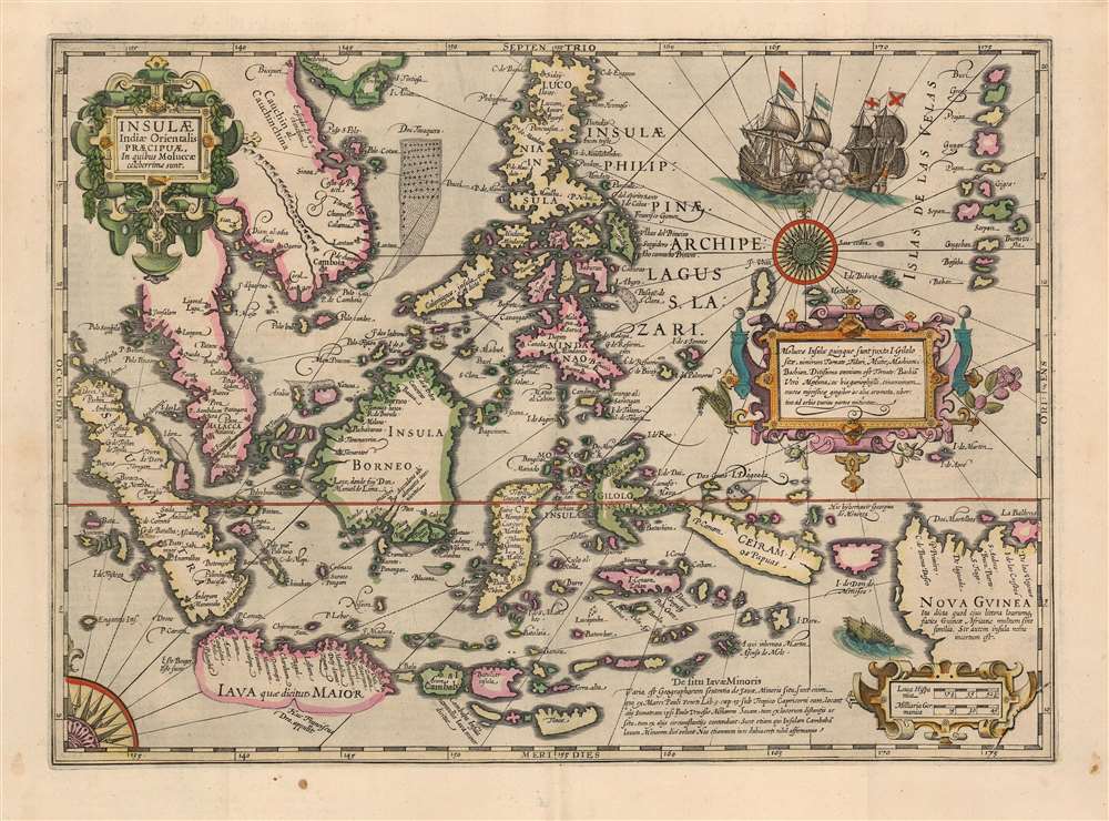
Insulae Indiae Orientalis Praecipuae, In quibus Moluccae celeberrime sunt.
1606 (undated) 13.5 x 18.75 in (34.29 x 47.625 cm) 1 : 11000000
1606 (undated) 13.5 x 18.75 in (34.29 x 47.625 cm) 1 : 11000000
Description
This is a beautiful, original color example of Jodocus Hondius' 1606 map of the East Indies and Spice Islands, reflecting state of the art cartography for the early years of Dutch influence there. It also includes details of English exploration, specifically Francis Drake's passage and landfalls during his circumnavigation.
The Scope of the Map
The map is centered on the Philippine Islands, reaching as far south as Timor, and extends from Sumatra in the west to New Guinea in the east. The map thus encompasses the southern Malay Peninsula, the coast of Vietnam, part of southern China, and the myriad islands from which the Dutch would begin extracting vast wealth over the course of the seventeenth century.Drake Was Here
As Thomas Suarez points out, 'Insulae Indiae Orientalis is one of the few maps to show any trace of Francis Drake’s presence in Southeast Asia'. The depiction of Sulawesi (here named Gilolo) is presented to reflect the treacherous coast that nearly wrecked Drake, and his pioneering landing on the southern coast of Java specifically names him 'Huc Franciscus Dra.' Hondius was uniquely well-placed to gain this information. The Protestant Hondius fled the low countries to London when the Eighty Years' War (c.1566/8 - 1648) turned particularly dangerous, culminating in the Spanish sack of Antwerp. News of Drake's voyage set London ablaze, and so it is not surprising that several of Hondius' maps reflect the flamboyant circumnavigator's deeds - even if the two had not been acquaintances, though they were.Descriptive Texts
In addition to annotations with respect to Drake, Hondius' work is rich in content. New Guinea, for example, is so described for its superficial similarity to the African Guinea coast. Hondius notes that it is not known whether or not New Guinea is even an island. (Many maps, including those of Mercator and Ortelius, frequently connected New Guinea with a massive Antarctic continent, sometimes even contiguous with Tierra del Fuego.) An attractively engraved strapwork cartouche contains a text block describing the rich spices found in the Moluccas, naming cinnamon, nutmeg, cloves, and ginger. Also, a note discusses the various possible locations of Java Minor proposed by various geographers. Several smaller notes - one marking Dom Manuel de Lima's visit to Borneo, and another marking the wintering-spot of Martin Afonso de Melo - reveal Hondius' Portuguese sources, derived from the charts of Bartolomeu Lasso.A Dramatic, Beautiful Engraving
Hondius' map is as decorative as it is informative. It features a lovely compass rose, whose style hints at the portolan charts that influenced this work. Two sailing ships appear locked in battle east of the Philippines, and a sea monster prowls the coast of New Guinea. Sandbanks and shoals are presented pictorially.Publication History and Census
This is among the maps engraved by Jodocus Hondius for his updated edition of the atlas published by Mercator's heirs. This specific example conforms typographically to both the 1628 and 1633 French editions of Atlas, edition decima published by Jodocus' heir, Henricus. The separate map is well represented in institutional collections and does appear on the market from time to time, although examples with original color of this quality are increasingly scarce.CartographerS
Jodocus Hondius (October, 14 1563 - February 12, 1612) was an important Dutch cartographer active in the late 16th and early 17th centuries. His common name, Jodocus Hondius is actually a Latinized version of his Dutch name, Joost de Hondt. He is also sometimes referred to as Jodocus Hondius the Elder to distinguish him from his sons. Hondius was a Flemish artist, engraver, and cartographer. He is best known for his early maps of the New World and Europe, for re-establishing the reputation of the work of Gerard Mercator, and for his portraits of Francis Drake. Hondius was born and raised in Ghent. In his early years he established himself as an engraver, instrument maker and globe maker. In 1584 he moved to London to escape religious difficulties in Flanders. During his stay in England, Hondius was instrumental in publicizing the work of Francis Drake, who had made a circumnavigation of the world in the late 1570s. In particular, in 1589 Hondius produced a now famous map of the cove of New Albion, where Drake briefly established a settlement on the west coast of North America. Hondius' map was based on journal and eyewitness accounts of the trip and has long fueled speculation about the precise location of Drake's landing, which has not yet been firmly established by historians. Hondius is also thought to be the artist of several well-known portraits of Drake that are now in the National Portrait Gallery in London. In 1593, Hondius returned to Amsterdam, where he remained until the end of his life. In 1604, he purchased the plates of Gerard Mercator's Atlas from Mercator's grandson. Mercator's work had languished in comparison to the rival atlas, Theatrum Orbis Terrarum by Ortelius. Hondius republished Mercator's work with 36 additional maps, including several which he himself produced. Despite the addition of his own contributions, Hondius recognizing the prestige of Mercator's name, gave Mercator full credit as the author of the work, listing himself as the publisher. Hondius' new edition of Mercator revived the great cartographer's reputation and was a great success, selling out after a year. Hondius later published a second edition, as well as a pocket version called the Atlas Minor. The maps have since become known as the "Mercator/Hondius series". Between 1605 and 1610 Hondius was employed by John Speed to engrave the plates for Speed's The Theatre of the Empire of Great Britaine. Following Hondius' death in 1612, his publishing work in Amsterdam was continued by his widow and two sons, Jodocus II and Henricus. Later his family formed a partnership with Jan Jansson, whose name appears on the Atlasas co-publisher after 1633. Eventually, starting with the first 1606 edition in Latin, about 50 editions of the Atlas were released in the main European languages. In the Islamic world, the atlas was partially translated by the Turkish scholar Katip Çelebi. The series is sometimes called the 'Mercator/Hondius/Jansson' series because of Jansson's later contributions. Hondius' is also credited with a number of important cartographic innovations including the introduction of decorative map borders and contributions to the evolution of 17th century Dutch wall maps. The work of Hondius was essential to the establishment Amsterdam as the center of cartography in Europe in the 17th century. More by this mapmaker...
Petrus Plancius (1522 - May 15, 1622) was a Dutch-Flemish cartographer, astronomer, and clergyman. Born in Dranouter, he studied theology in Germany and England. He became a minister in the Dutch Reformed Church at the age of 24. In 1585, fearing religious prosecution by the Inquisition after Brussels fell into Spanish hands, Plancius fled to Amsterdam. It was in Amsterdam that he became interested in navigation and cartography and soon became a recognized expert on the shipping routes to India. Plancius published his best known world map in 1592, entitled ‘Nova et exacta Terrarum Tabula geographic et hydrographica’. Plancius was also one of the founders of the Dutch East India Company, for which he drew over 100 maps. Learn More...
Source
Hondius, H., Atlas, edition decima, (Amsterdam: Hondius) 1628.
Condition
Very good. Few marginal spots, else excellent with superb original color.
References
OCLC 159850001. Van der Krogt, P. C. J., Koeman's Atlantes Neerlandici, (3 Vols), 8500:1A. Suarez, T., Mapping of Southeast Asia, pp. 193-96.