
This item below is out of stock, but another example (left) is available. To view the available item, click "Details."
Details
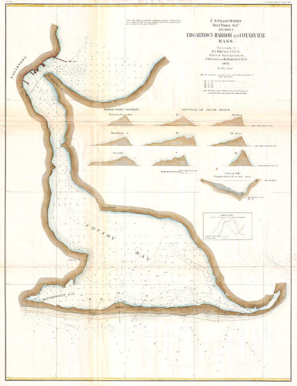
1871 U.S. Coast Survey Map or Chart of Edgartown Harbor, Martha's Vineyard, Massachusetts
$750.00
1871 U.S. Coast Survey Map or Chart of Edgartown Harbor, Martha's Vineyard, Massachusetts
Edgartown-uscs-1871$237.50

Title
Section I, Edgartown Harbor and Cotamy Bay, Mass.
1871 (dated) 29 x 22 in (73.66 x 55.88 cm)
1871 (dated) 29 x 22 in (73.66 x 55.88 cm)
Description
A very rare 1872 U.S. Coast Survey Map of Edgartown and Cotamy Bay on Martha's Vineyard (Marthas Vineyard), Massachusetts. Depicts from Edgartown south to Mattakeesett Bay and east to the 'Opening of 1846.' Offers a countless depth soundings throughout as sell as 10 shore sectionals. An extremely uncommon find. The topography for this map was prepared by H. L . Whiting. The Hydrography is the work of Henry Mitchell (See biography below for H. Mitchell, son of William Mitchell) and H. I. Marindin. All work on this chart was completed by the Coast Survey under the direction of Benjamin Pierce, Superintendent of the Survey.
CartographerS
The Office of the Coast Survey (1807 - present) founded in 1807 by President Thomas Jefferson and Secretary of Commerce Albert Gallatin, is the oldest scientific organization in the U.S. Federal Government. Jefferson created the "Survey of the Coast," as it was then called, in response to a need for accurate navigational charts of the new nation's coasts and harbors. The spirit of the Coast Survey was defined by its first two superintendents. The first superintendent of the Coast Survey was Swiss immigrant and West Point mathematics professor Ferdinand Hassler. Under the direction of Hassler, from 1816 to 1843, the ideological and scientific foundations for the Coast Survey were established. These included using the most advanced techniques and most sophisticated equipment as well as an unstinting attention to detail. Hassler devised a labor intensive triangulation system whereby the entire coast was divided into a series of enormous triangles. These were in turn subdivided into smaller triangulation units that were then individually surveyed. Employing this exacting technique on such a massive scale had never before been attempted. Consequently, Hassler and the Coast Survey under him developed a reputation for uncompromising dedication to the principles of accuracy and excellence. Unfortunately, despite being a masterful surveyor, Hassler was abrasive and politically unpopular, twice losing congressional funding for the Coast Survey. Nonetheless, Hassler led the Coast Survey until his death in 1843, at which time Alexander Dallas Bache, a great-grandson of Benjamin Franklin, took the helm. Bache was fully dedicated to the principles established by Hassler, but proved more politically astute and successfully lobbied Congress to liberally fund the endeavor. Under the leadership of A. D. Bache, the Coast Survey completed its most important work. Moreover, during his long tenure with the Coast Survey, from 1843 to 1865, Bache was a steadfast advocate of American science and navigation and in fact founded the American Academy of Sciences. Bache was succeeded by Benjamin Pierce who ran the Survey from 1867 to 1874. Pierce was in turn succeeded by Carlile Pollock Patterson who was Superintendent from 1874 to 1881. In 1878, under Patterson's superintendence, the U.S. Coast Survey was reorganized as the U.S. Coast and Geodetic Survey (C & GS) to accommodate topographic as well as nautical surveys. Today the Coast Survey is part of the National Oceanic and Atmospheric Administration or NOAA as the National Geodetic Survey. More by this mapmaker...
Henry Mitchell (September 16, 1830 – December 1, 1902) was an American oceanographer and hydrographer, and a co-founder of the National Geographic society. Born in Nantucket to surveyor and astronomer William Mitchell (December 20, 1791 - April 19, 1868), Henry joined the U.S. Coastal survey at the age of 19, and produced for the survey many charts of the waters near his home, both on Nantucket and Martha's Vineyard. He worked for four years to produce a chart of New York Harbor, which was hailed as the most accurate of its contemporaries. During his service with the survey he devised new methods for measuring tides and currents, advancing the science of hydrography beyond the production of new charts. He traveled extensively, visiting Europe to study the old world's canals, dykes and harbors, and even visited the Suez Canal in Egypt as it neared completion. In 1888 he would be among the thirty-three luminaries to found the National Geographic Society, proving instrumental in bridging fields in order to build the multidisciplinary foundation upon which the Society was based. Learn More...
Source
Report of the Superintendant of the U.S. Coast Survey, (1872 edition).
Condition
Very good condition. Minor wear, verso repairs, and toning on original fold lines. Else clean.