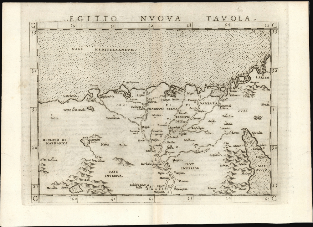
1561 Ruscelli / Gastaldi Map of Egypt and the Lower Nile
Egypt-ruscelli-1561$350.00

Title
Egitto Nuova Tavola.
1561 (undated) 7.5 x 9.5 in (19.05 x 24.13 cm) 1 : 3000000
1561 (undated) 7.5 x 9.5 in (19.05 x 24.13 cm) 1 : 3000000
Description
This is Girolamo Ruscelli's 1561 map of Egypt. It is the second modern map of the Lower Nile, predated only by the 1548 Gastaldi map, upon which it is based. It is among the earliest acquirable maps to show the Nile Delta with contemporaneous information; it is also one of the first printed maps to depict the Egyptian Pyramids.
While a later derivative of the 1548 Gastaldi map, this Ruscelli has much to recommend it. Ruscelli's iteration of the map is twice the size of the Gastaldi, and Sanuto's engraving is far superior to that of the earlier work.
A Closer Look
Ruscelli's map follows the 1548 map of fellow Venetian Giacomo Gastaldi; the elegant engraving here was executed by Giulio Sanuto. It extends from the desert of Marmarica (eastern Libya) to the Sinai Peninsula and the northern part of the Red Sea. It is centered on the Nile River Delta; its southernmost placename on the Nile is Manfalut, still an extant placename. Many cities are noted, including Alexandria, Cairo, and Rosetta. At several points along the west bank of the Nile, pyramids are noted, not just the site of the Great Pyramids at Giza, but further south as well, perhaps corresponding to the Roman-era Qasr El-Farafra rather than more ancient Pyramids. Gastaldi's sources are unknown. Some features - such as the Torre de li Arabi, found to the west of Alexandria - appear in Medieval sources such as the c. 1320 Sanuto-Vesconte and the c. 1375 Catalan Atlas. But Gastaldi's overall presentation of the Nile Delta, replete with its modern placenames and placement of the Pyramids, has no known precursor. Considering Gastaldi's other Tabulae Modernae, his sources may have been Portuguese; certainly, the Portuguese were eagerly exploring northeastern Africa and the Nile during the early 16th century. Many of the placenames appear to be Latinizations of Arabic names, so it is also possible that Gastaldi had more direct reports.While a later derivative of the 1548 Gastaldi map, this Ruscelli has much to recommend it. Ruscelli's iteration of the map is twice the size of the Gastaldi, and Sanuto's engraving is far superior to that of the earlier work.
Publication History and Census
This map was engraved by Giulio Sanuto for inclusion in the 1561 first edition of La Geografia di Claudio Tolomeo. The first state can be recognized by a pressmark that runs off the top of the page, as here. Beginning in 1574, a second state of the plate appears, with a platemark running fully around the map. A third state appeared in 1598 with a new letterpress title and the addition of a sea monster and a sailing galley. Four examples of the separate map are listed in OCLC; the map does appear on the market from time to time.CartographerS
Girolamo Ruscelli (1500 - 1566) was an Italian polymath, humanist, editor, and cartographer active in Venice during the early 16th century. Born in Viterbo, Ruscelli lived in Aquileia, Padua, Rome and Naples before relocating to Venice, where he spent much of his life. Cartographically, Ruscelli is best known for his important revision of Ptolemy's Geographia, which was published posthumously in 1574. Ruscelli, basing his work on Gastaldi's 1548 expansion of Ptolemy, added some 37 new "Ptolemaic" maps to his Italian translation of the Geographia. Ruscelli is also listed as the editor to such important works as Boccaccio's Decameron, Petrarch's verse, Ariosto's Orlando Furioso, and various other works. In addition to his well-known cartographic work many scholars associate Ruscelli with Alexius Pedemontanus, author of the popular De' Secreti del R. D. Alessio Piemontese. This well-known work, or "Book of Secrets" was a compilation of scientific and quasi-scientific medical recipes, household advice, and technical commentary on a range of topics that included metallurgy, alchemy, dyeing, perfume making. Ruscelli, as Alexius, founded a "Academy of Secrets," a group of noblemen and humanists dedicated to unearthing "forbidden" scientific knowledge. This was the first known experimental scientific society and was later imitated by a number of other groups throughout Europe, including the Accademia dei Secreti of Naples. More by this mapmaker...
Giacomo Gastaldi (c. 1500 - October, 1566) was an Italian astronomer, cartographer, and engineer active in the second half of the 16th century. Gastaldi (sometimes referred to as Jacopo or Iacobo) began his career as an engineer, serving the Venetian Republic in that capacity until the fourth decade of the sixteenth century. During this time he traveled extensively, building a large library relating to voyages and exploration. From about 1544 he turned his attention to mapmaking, working extensively with Gextantiovanni Battista Ramusio, Nicolo Bascarini, and Giovanbattista Pedrezano, as well as taking private commissions for, among others, Venice's Council of Ten. He is credited with the fresco maps of Asia and Africa still extant in the map room of the Doge's Palace. Gastaldi was also one of the first cartographers to embrace copper plate over woodblock engraving, marking an important development in the history of cartography. His 1548 edition of Ptolemy's Geographia was the first to be printed in a vernacular; it was the first to be printed in copperplate. As with his Swiss/German contemporary Münster, Gastaldi's work contained many maps depicting newly discovered regions for the first time, including the first map to focus on the East Coast of North America, and the first modern map of the Indian Peninsula. His works provided the source for the vast majority of the Venetian and Roman map publishers of the 1560s and 70s, and would continue to provide an outsize influence on the early maps of Ortelius, De Jode, and Mercator. Learn More...
Giulio Sanuto (fl. 1540 – 1580) was a Venetian engraver. He was born the illegitimate son of Cavaliere Francesco di Angelo Sanuto; With his brother, the cartographer and scientific instrument maker Livio Sanuto (1520 – 1576) he produced an array of some of the most important geographical works produced in Venice during the second half of the sixteenth century. These included a 27-inch globe and the 1588 12-sheet atlas, Geografia della Africa. Giulio's career is singluar among Venice's engraves in that it appears to have been equally based on artistic, figurative work as well as his cartographic works. Giulio is more broadly known for a small but sought-after selection of decorative engravings; no more than twelve of these can be attributed confidently to him, including the monumental Apollo and Marsyas, measuring over 1.30 meters wide. Whilst Sanuto's engravings were generally based upon the designs of other artists, his work was both ambitious and grand, and he often signed these works. Learn More...
Source
Ruscelli, G., La Geografia di Claudio Tolomeo Alessandrino…, (Venice: Giordano Ziletti) 1574.
Beginning in 1561, Girolamo Ruscelli published this important, expanded edition of Giacomo Gastaldi's 1548 Ptolemy. Its maps, engraved in Venice by Giulio Sanuto, were in the main based directly upon those in Gastaldi's 1548 work. The maps were larger format than Gastaldi's, however, and Sanuto's engraving was far clearer and more legible than those appearing in the 1548 work. There are some important additions that distinguish Ruscell's Ptolemy from Gastaldi's. Ruscelli's work contained a map of the habitable world according to Ptolemy, which the Gastaldi lacked; also, the double-hemisphere map appearing in the Ruscelli was new and did not appear in the Gastaldi. Ruscelli's modern map of England was based on the work of George Lily, rather than the Waldseemüller-derived map appearing in the Gastaldi; the Ruscelli is the earliest generally acquirable map of England based on knowledge from someone who lived there. In a fateful innovation, Ruscelli's work included Septentrionalium partium nova tabula,the first copy of Nicolo Zeno's 1558 fraud Carta da Navegar, which introduced a novel mapping of the north parts of the world, including the phantom islands of Frisland, Icaria, Drogeo and Estotiland. Had Ruscelli not copied the Zeno - which had a narrow, brief publication - this preposterous geography would have probably not taken hold. Its inclusion in Ruscelli's beautiful, authoritative and popular work would lead to the adoption of the Zeno map by Mercator, Ortelius, Plancius and their successors, baffling scholars for centuries. Ruscelli's Ptolemy had a long publication history, cementing the influence of the work. It appeared both in Italian and Latin editions, all printed in Venice, throughout the latter 16th century:
- 1561 La Geographia di Claudio Tolomeo Alessandrino, Italian. Venice, Vincenzo Valgrisi.
- 1562 Geographia Cl. Ptolemaei Alexandrini, Latin. Venice, Vincenzo Valgrisi.
- 1564 La Geographia di Claudio Tolomeo Alessandrino, Italian. Venice, Giordano Ziletti.
- 1564 Geographia Cl. Ptolemaei Alexandrini, Latin. Venice, Giordano Ziletti.
- 1574 La Geographia di Claudio Tolomeo Alessandrino, Italian. Venice, Giordano Ziletti.
- 1598 Geographia di Claudio Tolomeo Alessandrino, Italian. Venice, heirs of Melchoir Sessa.
- 1599 Geographia di Claudio Tolomeo Alessandrino, Italian. Venice, heirs of Melchoir Sessa.
Condition
Excellent. Very faint offsetting, else fine with generous margins.
References
OCLC 165592081. Rumsey 11311.117 (1561).