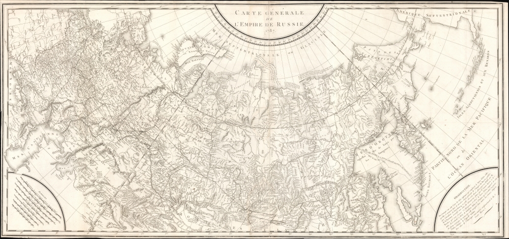
1787 Tardieu Map of the Russian Empire
EmpireRussie-tardieu-1787$650.00


Title
Carte Générale de L'Empire de Russie 1787.
1787 (dated) 22.25 x 47.5 in (56.515 x 120.65 cm) 1 : 21000000
1787 (dated) 22.25 x 47.5 in (56.515 x 120.65 cm) 1 : 21000000
Description
An intricate large-scale c. 1787 French-language map of the Russian Empire engraved by Pierre-François Tardieu. It represents a significant improvement on earlier maps of the empire, especially its eastern portions and the northern Pacific, as both Russian and western European voyages of exploration proliferated in the late 18th century.
This map was produced at a time when Russia's empire was near the peak of its expansion and interest in Siberia, the Pacific, and Alaska at its apex. In 1799, Tsar Paul I provided a charter for the Russian-American Company and established territorial claims to much of today's Alaska. In the following decades, Russian traders would range as far south as Hawaii and the San Francisco Bay Area. But the rapid depletion of fur stocks and more pressing concerns closer to the imperial center of Moscow-St. Petersburg, namely the Napoleonic Wars (1803 - 1815), caused Russian interest in the northern Pacific to wane in the early 19th century, allowing Britain and the United States to become preeminent in the region.
This map is only independently cataloged with the Newberry Library, Harvard University, and the National Library of Scotland, while Pallas' entire Voyages is more widely distributed. Yale University's Beinecke Rare Book and Manuscript Library holds a slightly different 1785 edition also attributed to Tardieu.
A Closer Look
Coverage stretches from what is now Poland, Ukraine, and Estonia in the west to Alaska and the Kuril Islands in the east, including recent acquisitions made under Catherine the Great, most notably Crimea, which was conquered from the Ottomans in 1783. Roads, waterways, mountains, settlements, and administrative borders are indicated throughout. Descriptive notes on recent voyages and discoveries are included along Russia's northern coast and in the bottom-right. Although an important advance on earlier maps, the geography of some areas, such as Sakhalin (Sahalien-Ouha) and Hokkaido (Yeso), is still 'under development,' as Tardieu freely admits. Nearby, the tracks of Russian expeditions to the Kuril Islands are recorded. Seven scales are provided, in part to account for the modified conic projection employed.This map was produced at a time when Russia's empire was near the peak of its expansion and interest in Siberia, the Pacific, and Alaska at its apex. In 1799, Tsar Paul I provided a charter for the Russian-American Company and established territorial claims to much of today's Alaska. In the following decades, Russian traders would range as far south as Hawaii and the San Francisco Bay Area. But the rapid depletion of fur stocks and more pressing concerns closer to the imperial center of Moscow-St. Petersburg, namely the Napoleonic Wars (1803 - 1815), caused Russian interest in the northern Pacific to wane in the early 19th century, allowing Britain and the United States to become preeminent in the region.
Early Revelation of Perouse's Discoveries
This map was engraved by Pierre-François Tardieu and is dated 1787, though the note at bottom-right mentions subsequent updates, including the incorporation of information from the voyage of La Perouse ('Peyrouse' here), which was not openly published until 1797. The map appeared in Vol. 6 of Peter Simon Pallas' Voyages en différentes provinces de l'Empire de Russie, et dans l'Asie septentrionale, published in 1793, a date consistent with the empire's borders, just on the eve of the Second Partition of Poland-Lithuania. These facts suggest that Tardieu had advanced knowledge of Perouse's discoveries, which is plausible as the expedition's journals were sent overland from Kamchatka across Russia with a stopover in St. Petersburg in 1788, where they were delivered to the French ambassador and then sent on to Paris. Either by way of interlocutors in St. Petersburg or through his proximity to the French crown, Tardieu's inclusion of said information was an early publication of Perouse's discoveries.Publication History and Census
More generally, Tardieu's map is based on a Russian original ('Генеральная карта Российской империи') first published in 1776 by the Imperial Academy of Sciences (Императорская академия наук) in St. Petersburg by a team including the prolific cartographer Ivan Treskot. It was revised and reissued several times thereafter as Russian geographical knowledge of the further reaches of Siberia and the Pacific, and of scientific cartography more generally, was developing rapidly at this time, and Tardieu looks to have used the 1787 edition of the Russian map as his basis.This map is only independently cataloged with the Newberry Library, Harvard University, and the National Library of Scotland, while Pallas' entire Voyages is more widely distributed. Yale University's Beinecke Rare Book and Manuscript Library holds a slightly different 1785 edition also attributed to Tardieu.
CartographerS
Pierre François Tardieu (1711 - 1771) was a French engraver and mapmaker active in Paris during the middle part of the 18th century and a member of the large and prolific Tardieu family. Several members of the family established themselves as engravers, and, for over 200 years, the family produced works. Pierre Francois Tardieu was born around 1711 in Paris, son of Jean Tardieu. His uncle, Nicolas-Henry Tardieu, taught him the art of engraving. Pierre was a general engraver whose work was not limited to maps but also included historical and genre works. Many of his maps are extremely significant and include some of the finest French productions of the period. Tardieu had his office at Rue de al Corderie, Paris. Tardieu was married to Marie-Anne Rousselet (1733-1826), whose family included the engraver Gilles Rousselet and the sculptor Jean Rousselet. It is highly likely that Pierre Francois Tardieu was succeeded by Pierre Antoine Francois Tardieu (1757 - 1822), who is also possibly his son, as the latter continued to engrave under the P. F. Tardieu imprint well after the former's death. More by this mapmaker...
Ivan (Johann) Fomic Treskot (Иван Фомич Трускотт; December 1, 1721 - May 18, 1786), also spelled Treskott, Truscott, or Truskot, was a Russian cartographer active in St. Petersburg in the late 18th century. Treskot was born in St. Peterburg, the son of an English merchant (perhaps the reason his name is sometimes recorded as John Truskott). He studied architecture and cartography at the Russian Academy of Sciences under Joseph-Nicolas De l'isle (April 4, 1688 – September 11, 1768) and Jacob Friedrich Schmidt (Якоб Фридрих Шмидт; 1723 - 1786). In 1746 he was made head of the Cartographic Department at the St. Petersburg Academy of Sciences. They went on to compile a detailed mapping of Siberia, publishing various regional maps from 1770 to 1776. Working with Schmidt, Treskot compiled the 1784 Tabula Geographica Generalis Imperii Russici, the finest general map of the empire since after the 1734 Kirilov. Treskot was active at the Russian Academy's Geographical Department for nearly 50 years, from 1737 to his death in 1786. While he supervised the construction of hundreds of maps, only 11 of which bear his imprint. Learn More...
Source
Pallas, Peter Simon, Voyages en différentes provinces de l'Empire de Russie, et dans l'Asie septentrionale, (Paris: Maradan) 1887 - 1793.
Condition
Good. Edges trimmed near neatline, likely by publisher.
References
OCLC 219450868, 316509383.