Digital Image: 1787 Tardieu Map of the Russian Empire
EmpireRussie-tardieu-1787_d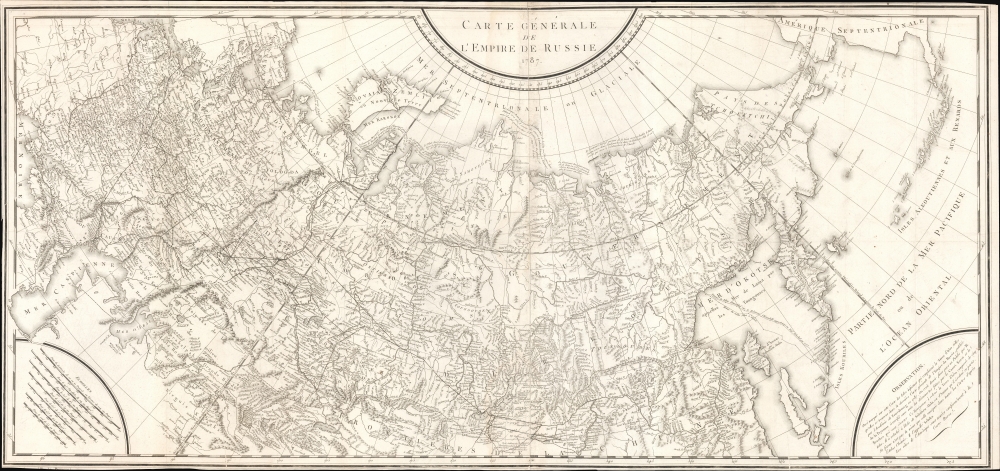


Title
Carte Générale de L'Empire de Russie 1787.
1787 (dated) 22.25 x 47.5 in (56.515 x 120.65 cm) 1 : 21000000
1787 (dated) 22.25 x 47.5 in (56.515 x 120.65 cm) 1 : 21000000
Description
FOR THE ORIGINAL ANTIQUE MAP, WITH HISTORICAL ANALYSIS, CLICK HERE.
Digital Map Information
Geographicus maintains an archive of high-resolution rare map scans. We scan our maps at 300 DPI or higher, with newer images being 600 DPI, (either TIFF or JPEG, depending on when the scan was done) which is most cases in suitable for enlargement and printing.
Delivery
Once you purchase our digital scan service, you will receive a download link via email - usually within seconds. Digital orders are delivered as ZIP files, an industry standard file compression protocol that any computer should be able to unpack. Some of our files are very large, and can take some time to download. Most files are saved into your computer's 'Downloads' folder. All delivery is electronic. No physical product is shipped.
Credit and Scope of Use
You can use your digial image any way you want! Our digital images are unrestricted by copyright and can be used, modified, and published freely. The textual description that accompanies the original antique map is not included in the sale of digital images and remains protected by copyright. That said, we put significant care and effort into scanning and editing these maps, and we’d appreciate a credit when possible. Should you wish to credit us, please use the following credit line:
Courtesy of Geographicus Rare Antique Maps (https://www.geographicus.com).
How Large Can I Print?
In general, at 300 DPI, you should at least be able to double the size of the actual image, more so with our 600 DPI images. So, if the original was 10 x 12 inches, you can print at 20 x 24 inches, without quality loss. If your display requirements can accommodate some loss in image quality, you can make it even larger. That being said, no quality of scan will allow you to blow up at 10 x 12 inch map to wall size without significant quality loss. For more information, it is best consult a printer or reprographics specialist.
Refunds
If the high resolution image you ordered is unavailable, we will fully refund your purchase. Otherwise, digital images scans are a service, not a tangible product, and cannot be returned or refunded once the download link is used.
Cartographer S
Pierre François Tardieu (1711 - 1771) was a French engraver and mapmaker active in Paris during the middle part of the 18th century and a member of the large and prolific Tardieu family. Several members of the family established themselves as engravers, and, for over 200 years, the family produced works. Pierre Francois Tardieu was born around 1711 in Paris, son of Jean Tardieu. His uncle, Nicolas-Henry Tardieu, taught him the art of engraving. Pierre was a general engraver whose work was not limited to maps but also included historical and genre works. Many of his maps are extremely significant and include some of the finest French productions of the period. Tardieu had his office at Rue de al Corderie, Paris. Tardieu was married to Marie-Anne Rousselet (1733-1826), whose family included the engraver Gilles Rousselet and the sculptor Jean Rousselet. It is highly likely that Pierre Francois Tardieu was succeeded by Pierre Antoine Francois Tardieu (1757 - 1822), who is also possibly his son, as the latter continued to engrave under the P. F. Tardieu imprint well after the former's death. More by this mapmaker...
Ivan (Johann) Fomic Treskot (Иван Фомич Трускотт; December 1, 1721 - May 18, 1786), also spelled Treskott, Truscott, or Truskot, was a Russian cartographer active in St. Petersburg in the late 18th century. Treskot was born in St. Peterburg, the son of an English merchant (perhaps the reason his name is sometimes recorded as John Truskott). He studied architecture and cartography at the Russian Academy of Sciences under Joseph-Nicolas De l'isle (April 4, 1688 – September 11, 1768) and Jacob Friedrich Schmidt (Якоб Фридрих Шмидт; 1723 - 1786). In 1746 he was made head of the Cartographic Department at the St. Petersburg Academy of Sciences. They went on to compile a detailed mapping of Siberia, publishing various regional maps from 1770 to 1776. Working with Schmidt, Treskot compiled the 1784 Tabula Geographica Generalis Imperii Russici, the finest general map of the empire since after the 1734 Kirilov. Treskot was active at the Russian Academy's Geographical Department for nearly 50 years, from 1737 to his death in 1786. While he supervised the construction of hundreds of maps, only 11 of which bear his imprint. Learn More...
Source
Pallas, Peter Simon, Voyages en différentes provinces de l'Empire de Russie, et dans l'Asie septentrionale, (Paris: Maradan) 1887 - 1793.
References
OCLC 219450868, 316509383.