
1674 Francesco Eschinardi Map of Ethiopia showing the Source of the Nile

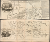

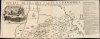

Imperii Abassini tabula geographica ex sculatis relationibus patrum soc. Jesu aliorumque inter se comparatis and ad trutinam regulae geographicae examinatis rejectis iis quae concordi eorumdem historiae que mater est geographiae repugnabant
Earliest Acquirable Map showing the True Source of the Blue Nile.
- Digital Map Information
- Suitable for large format printing
- Full resolution TIFF file
- ICC color profile embedded
- Delivered instantly via download link
Earliest Acquirable Map showing the True Source of the Blue Nile.
This is Francesco Eschinardi's rare 1674 map of Abyssinia (Ethiopia) in Eastern Africa. It is the first detailed map focusing on the headwaters of the Blue Nile, informing regional cartography for a century. It is also the largest map to focus on this region for at least a century, being printed to four separate sheets, joined in upper and lower pairs. Its geographic detail is supplemented with pictorial mountains, depictions of the region's notable animals, settlements, ruins, and scenes of the martyrdom of Jesuit missionaries at the hands of both Abyssinian Christian 'heretics' and their Ottoman overlords. The map includes two inset views: one of the church complex of the Tadbaba Maryam and a bird's-eye view of the source of the Nile.A Closer Look
This grand map - printed to four sheets, and joined in pairs for binding - presents a broad swath of east Africa encompassing northern Ethiopia and Eritrea. It centers on Lake Tana - then understood as the source of the River Nile. Detail extends as far north as Asmara, Massawa, and Dahlak Island; as far south as Boxa, in Ennarea on the Gibe (Zebe) River, and the Awash River (Haoaxe). The map is rich in recognizable place names, derived from a long history of Portuguese Jesuit exploration. Mountains are shown pictorially, with scattered trees. In addition to towns, the map includes depictions of traditional, round, Ethiopian houses as well as rectangular European structures, mainly churches. Fauna illustrated includes herds of goats and camels, monkeys, elephants, and what are among the earliest depictions of Hippopotami (famous denizens of Lake Tana to this day). At right, an alphabetized gazetteer provides a key to locations on the map; at the end of this list are notations for notable Jesuit martyrdoms, letter-keyed to the map.In the upper left is an inset birds' eye view of the valley of Tadbaba Maryam (still a place of great mystery, reputed to be a resting place for the Ark of the Covenant). On the map proper, the location is placed atop a great mountain outside the bend of the Blue Nile; the view puts the church and its surrounding structures amidst a rocky mountain valley. The view of the source of the Nile, in the lower left, is similarly fascinating, with the river issuing from channels through mountains. Both of these views are tantalizingly keyed with letters, suggesting that map was intended to be accompanied by a printed legend - such a legend was not included on the map itself, and did not appear in the text of either the 1674 or 1684 editions of Recueil de divers voyages faits en Afrique et en l'Amérique , in which this map appeared. The presence of the letters, and the absence of their key in any known surviving printed work, suggests that either Eschinardi's intention to provide a key was ignored by his publishers, or that the map had actually appeared so a now-unknown work predating the 1674 Recueil.
Correcting the Ptolemaic Model of the Nile
The Nile and its sources had long been topic of geographical curiosity. Claudius Ptolemy, in the second century C.E., proposed that the river was fed by the two massive lakes, Zaire and Zaflan, which in turn were fed by streams from the Mountains of the Moon. Despite improvements in the mapping of Africa occurring throughout the age of discovery, no new geographic ideas supplanted the Ptolemaic model until the 17th century.In 1618, the Spanish Jesuit missionary Pedro Páez y Jaramillo was the first European to document the source of the Blue Nile as Lake Tana, but this idea would not be presented cartographically for decades. A manuscript map by another Portuguese Jesuit, Manuel de Almeida, was produced but not published in his lifetime. That original was lost, but a photographic copy survives in the Bibliothèque Nationale de France, depicting Lake Tana as a horizontally oriented bean-shaped body of water in the curl of the Blue Nile - very superficially resembling the shape of the lake chosen by Eschinardi. In 1660, Baltazar Téllez abridged Almeida's work in his own 1660 Historia Geral de Ethiopia, and that work included the map which formed the basis for Eschinardi's, albeit featuring a vertically oriented, heart-shaped Lake Tana. Both the Almeida manuscript and the Téllez disassociated the Blue Nile from the Ptolemaic lakes and showed the Nile flowing from the southeast part of Lake Tana around Gojam, before heading north. This model accurately placed Ethiopia's latitude, making it quite recognizable in many respects. Eschinardi's map is not only much larger than the Téllez but is also far more detailed; it blends a battery of Jesuit sources, and it was sufficiently authoritative to have been adopted by Pierre DuVal for inclusion in his 1679, four-sheet map of Africa, whose depiction of Lake Tana resembles that which appears here.
Publication History and Census
The present example of Francesco Eschinardi's map was engraved on four plates, joined in pairs for binding; it appeared in the 1674 edition of Henri Justel's Recueil de divers Voyages faits en Afrique et en l'Amérique, and would appear again without substantial change in the subsequent 1684 edition. If it was produced specifically for Justel's Recueil, it might be presumed to have been engraved by René Michault (fl. c. 1668 - 1685); his imprint, however, does not appear on any of these plates, as it does on several of the other maps in the work. The absence of a key page in either edition of the Recueil suggests that the map may have been engraved for inclusion in an earlier work, either not published or not yet identified. While Justel's Recueil is well represented in institutional collections, the separate map is listed only seven times in OCLC. It is quite rare on the market - we see only five examples at auction or in dealers' catalogs going back to 1993.Cartographer
Francesco Eschinardi (December 13, 1623 - January 12, 1703), also known by the pseudonym Costanzo Amichevoli, was an Italian Jesuit, cartographer, physicist, and mathematician. He was born in Rome, but details regarding his childhood are nonexistent until his 1637 entry to the Society of Jesus at 14. There he remained, eventually becoming a professor of logic, physics, and metaphysics at the Roman College, traveling throughout Italy to teach at other universities. While Eschinardi is not primarily noted for his maps, he was a skilled astronomer and familiar with scientific movements and the great thinkers of his day, including Copernicus and Galileo (despite his own affirmation of the geocentric theory). He was the first to observe the Comet of 1668; he was among the first to see the Great Comet of 1680, and it was from him that Cassini and Halley received the observation. Eschinardi was also fascinated by history: he corresponded with Halley on the archaeology of Rome, and his cartographic work relied on comparing existing models, corrected with the application of historical reports. In addition to Cassini and Halley, he also collaborated with Jesuit scholars Athanasius Kircher and Mario Bettinus. Eschinardi published widely on mechanics and astronomy. His geographical writings included one of the earliest proposals for a canal connecting the Mediterranean and the Red Sea. He also produced maps of Rome, and, in 1674, one of the first, detailed, printed maps of Abysinnia. Further Details...
Source
Justel, Henri, Recueil de divers voyages faits en Afrique et en l'Amerique, (Paris: Billaine) 1674.
Condition
Very good. Few marginal mends; wear at some junctures of folds, else excellent with generous margins. Printed to four sheets, joined in upper and lower pairs for binding. Upper sheets 13.75 x 35.5 inches; lower sheets. 14.25 x 36.25
References
OCLC 494400089. Afriterra 327 (1684)