
This item below is out of stock, but another example (left) is available. To view the available item, click "Details."
Details
1548/ 1606 Johann Stumpf Map of Europe
$4,000.00
1548 Johann Stumpf Map of Europe
Europe-stumpf-1548$2,250.00

Title
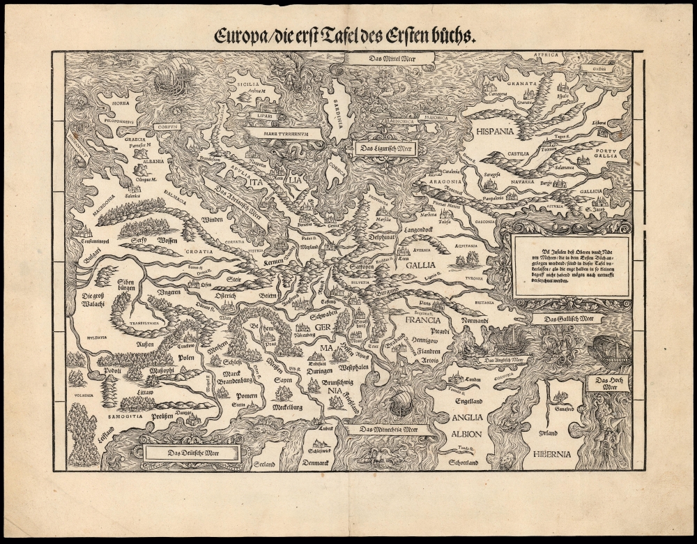
Europa die erst Tafel des Ersten Buchs.
1548 (undated) 11.5 x 15.25 in (29.21 x 38.735 cm) 1 : 8110000
1548 (undated) 11.5 x 15.25 in (29.21 x 38.735 cm) 1 : 8110000
Description
This is a rare, 1548 example of Johann Stumpf's southern oriented map of Europe. It is the only map derived from Sebastian Münster's map of the continent, and thus is the last derivative of Martin Waldseemüller's unobtainable 1511 map of Europe. While Münster's map went to many editions and is readily acquirable, Stumpf's work was produced in significantly smaller numbers and consequently is a much rarer work. It is moreover larger and more beautifully executed, and is consequently more desirable.
In most other geographical respects, Stumpf's map mirrors Münster's. It embraces Spain and part of Ireland to the west and extends eastwards to include the Black Sea coast and the mouth of the Danube, Bulgaria, Moldavia, and Livonia. The African shores of Gibraltar appear to the south, as does Sicily. The northern reaches fall beyond the scope of this map, which truncates Ireland and Scotland, shows only the southern portion of Denmark, and only the southernmost extent of Sweden. The body of the map is rich with the place names of the greatest cities of the era: nations are named as well. Mountain ranges are reasonably accurately placed, as are Europe's major rivers. Forest regions are also indicated pictorially.
The Precursor Maps
Stumpf drew the map in 1544, delivering it to formschneider Heinrich Vogtherr for wood engraving and printing. Like the Münster's map, Stumpf's is a reduced, single-sheet iteration of Waldseemüller's 1511 Carta itineraria Europae, sharing with that work its distinctive, southern orientation. The heart of Waldseemüller's map - the Holy Roman Empire - was itself based on the 1500 and 1501 traveler’s maps of Erhard Etzlaub (1455 - 1532). These maps, which remained the best detailed contemporaneous maps of German lands during Waldseemüller's day, were oriented to the south as a matter of utility: they were intended to be used to orient a traveler to the noonday sun. Also, of all of the maps available to Waldseemüller in the composition of his new map of Europe, Etzlaub's were not only the most detailed and up to date, they were also the most important, covering as they did his homeland. So rather than alter those core maps to conform to the ancient, Ptolemaic geography dictated by the maps of other parts of Europe, Waldseemüller bent those other maps to be in line with the most modern German maps available. The inherent modernity of this map was not lost on Münster, who would entitle his much smaller map as 'Europe, a Third Part of the World: Useful to Our Era.' Thus, the southern orientation of the map is neither an error nor a touch of whimsy, but rather an indication of the map's modernity. Stumpf's decision to model his map after Münster's was likely guided in part by this modernity, but it was probably the most easily accessible contemporary map at the time. Stumpf was situated in Switzerland and had lived in Basel, where Münster also lived and worked. Indeed, Münster considered Stumpf a competitor, and was aware that Stumpf's history of Switzerland contained matter that was based on his. It is possible also that, once he realized Stumpf's work would be confined to Switzerland, Münster actively collaborated with the other scholar. Certainly, Münster provided no interference - although the beauty and number of the woodcuts in Stumpf's history inspired Münster to rise to the challenge, resulting in the much expanded 1550 edition of his Cosmographia.The Map's Scope and Content
Stumpf, like Münster, was German Swiss, and in employing the model of the Waldseemüller and Münster maps, he emphasized the map's German-ness as well as its modernity. While many of the placenames employed throughout use Latin conventions, more of them are in German than on the Münster. In most respects, the map's topography mirrors that of its model. Stumpf's map contains a notable, material correction in its delineation of the Vistula River in Poland. Münster's river finds its source in the vicinity of Lithuania, perhaps conflating it with the Narew River or the Bug. Stumpf correctly places the source of the Vistula in the mountains to the south of Krakow. This correction may have resulted from a more correct interpretation of Waldseemüller's admittedly confusing representation of the river network, or it might indicate the influence of Wapowski's map of Poland, which Münster himself copied, although not on his map of Europe.In most other geographical respects, Stumpf's map mirrors Münster's. It embraces Spain and part of Ireland to the west and extends eastwards to include the Black Sea coast and the mouth of the Danube, Bulgaria, Moldavia, and Livonia. The African shores of Gibraltar appear to the south, as does Sicily. The northern reaches fall beyond the scope of this map, which truncates Ireland and Scotland, shows only the southern portion of Denmark, and only the southernmost extent of Sweden. The body of the map is rich with the place names of the greatest cities of the era: nations are named as well. Mountain ranges are reasonably accurately placed, as are Europe's major rivers. Forest regions are also indicated pictorially.
A Magnificent Woodcut
Stumpf's engraving is aesthetically far superior to the comparatively rudimentary Münster. The oceans are beautifully and evocatively rendered, and while Münster's map is embellished with one ship, the present work is abundantly decorated with ships, sea monsters, and its florally-framed cartouches. Off the coast of Sardinia, a merman astride a sea serpent plays a viol.Publication History and Census
Stumpf drew this map in 1544, and it was given to formschneider Heinrich Vogtherr in Strassburg to be committed to woodblock. It was first printed in the 1548 first edition of Stumpf's chronicle of Switzerland, Gemeiner löblicher Eydgnoschaft stetten, Lannden und Völckern chronicwirdiger Thaaten beschreybung. The letterpress title varies from edition to edition of this map, and the title of this example corresponds with the 1548 first edition. It would appear in others of Stumpf's works with different typesetting in 1556, 1562, and 1574. While Stumpf's chronicle is well represented in institutional collections, only two separate examples of this edition of the map are listed in institutional collections.CartographerS
Johann Stumpf (April 23, 1500 - 1578) was a German-Swiss historian, theologian and cartographer. was an early writer on the history and topography of Switzerland as well as a theologian and cartographer. He was born at Bruchsal in Germany, and was educated there, at Strasbourg and in Heidelberg. In 1520 he became a Catholic chaplain with the Knights Hospitaller. In 1521 the order sent him south to Freiburg im Breisgau, and on to Basel, where he would be ordained. In 1522 he was placed in charge of a preceptory in the canton of Zürich. In the years following Stumpf became an active Protestant theologian: he took part in the Bern Disputation and participated in the first Kappel War. His first marriage in 1529 would be to the daughter of Swiss historian Heinrich Brennwald, whose manuscript history inspired his son-in-law to take up that discipline. Stumpf's research was not only textual: he traveled in order to support his work. His opus - Gemeiner loblicher Eydgnoschafft Stetten, Landen und Voelckeren Chronick wirdiger thaaten Beschreybung - was published in 1548, and contained an array of beautiful woodcut maps. An extract of it would be republished in 1554 entitled Schwytzer Chronika. Enlarged editions of the original work were issued in 1586 and 1606. In addition to his historical work, he would continue as a Protestant pastor until 1561. He retired to Zurich in 1561, where his life would end in 1576. More by this mapmaker...
Heinrich Vogtherr (1490-1556) was a German artist, printer, poet and medical author. He was born in Dillingen an der Donau, son of an eye doctor and surgeon. His art training is thought to have tken place in Augsburg, under Hans Burgkmair. He traveled throughout Germany between 1518 and 1524, publishing numerous religious, Reformation-oriented poems and pamphlets and broadsheets. He took part as a colonel in the German Peasants' War in 1524 and 1525, escaping the failed siege of Radolfzell and finding his way to Strasbourg, where he settled. His religious background constrained his efforts to find work, and he had to work mainly as a book illustrator on behalf of a broad array of Strasbourg printers. In 1536 he founded his own print business, traveling frequently between Strasbourg, Speyer, Augsburg, Zurich, and Basel. He provided more than 400 woodcuts for Johannes Stumpf's 'Swiss chronicle, including many of its maps. In 1550 he relocated to Vienna at the behest of Ferdinand I, who would soonm become Holy Roman Emperor in 1556. Vogtherr would not survive long enough to enjoy Imperial patronage: he died that same year. Learn More...
Sebastian Münster (January 20, 1488 - May 26, 1552), was a German cartographer, cosmographer, Hebrew scholar and humanist. He was born at Ingelheim near Mainz, the son of Andreas Munster. He completed his studies at the Eberhard-Karls-Universität Tübingen in 1518, after which he was appointed to the University of Basel in 1527. As Professor of Hebrew, he edited the Hebrew Bible, accompanied by a Latin translation. In 1540 he published a Latin edition of Ptolemy's Geographia, which presented the ancient cartographer's 2nd century geographical data supplemented systematically with maps of the modern world. This was followed by what can be considered his principal work, the Cosmographia. First issued in 1544, this was the earliest German description of the modern world. It would become the go-to book for any literate layperson who wished to know about anywhere that was further than a day's journey from home. In preparation for his work on Cosmographia, Münster reached out to humanists around Europe and especially within the Holy Roman Empire, enlisting colleagues to provide him with up-to-date maps and views of their countries and cities, with the result that the book contains a disproportionate number of maps providing the first modern depictions of the areas they depict. Münster, as a religious man, was not producing a travel guide. Just as his work in ancient languages was intended to provide his students with as direct a connection as possible to scriptural revelation, his object in producing Cosmographia was to provide the reader with a description of all of creation: a further means of gaining revelation. The book, unsurprisingly, proved popular and was reissued in numerous editions and languages including Latin, French, Italian, and Czech. The last German edition was published in 1628, long after Münster's death of the plague in 1552. Cosmographia was one of the most successful and popular books of the 16th century, passing through 24 editions between 1544 and 1628. This success was due in part to its fascinating woodcuts (some by Hans Holbein the Younger, Urs Graf, Hans Rudolph Manuel Deutsch, and David Kandel). Münster's work was highly influential in reviving classical geography in 16th century Europe, and providing the intellectual foundations for the production of later compilations of cartographic work, such as Ortelius' Theatrum Orbis Terrarum Münster's output includes a small format 1536 map of Europe; the 1532 Grynaeus map of the world is also attributed to him. His non-geographical output includes Dictionarium trilingue in Latin, Greek, and Hebrew, and his 1537 Hebrew Gospel of Matthew. Most of Munster's work was published by his stepson, Heinrich Petri (Henricus Petrus), and his son Sebastian Henric Petri. Learn More...
Martin Waldseemüller (September 11, 1470 - March 16, 1520) was a German cartographer, astronomer, and mathematician credited with creating, along with Matthias Ringmann, the first map to use the placename America. He was born in Wolfenweiler, near Freiburg im Breisgau. Waldseemüller studied at the University of Freiburg and, on April 25, 1507, became a member of the Gymnasium Vosagese at Saint-Dié. Martin Waldseemüller was a major proponent of theoretical or additive cartography. Unlike contemporary Portuguese and Spanish cartographers, who left maps blank where knowledge was lacking, Waldseemüller and his peers speculated based upon geographical theories to fill unknown parts of the map. He is best known for his Universalis Cosmographia a massive 12-part wall map of the world considered the first map to contain the name America, today dubbed as 'America's Birth Certificate'. This map also had significance on other levels, as it combined two previously unassociated geographical styles: Ptolemaic Cartography, based on an ancient Greek model, and the emergent 'carta marina', a type of map commonly used by European mariners in the late 15th and 16th centuries. It also extended the traditional Ptolemaic model westward to include the newly discovered continent of America, which Waldseemüller named after the person he considered most influential in its discovery, Amerigo Vespucci. When Waldseemüller died in 1520, he was a canon of the collegiate Church of Saint-Dié. In contemporary references his name is often Latinized as Martinus Ilacomylus, Ilacomilus, or Hylacomylus. Learn More...
Source
Stumpf, J., Gemeiner löblicher Eydgnoschaft stetten, Lannden und Völckern chronicwirdiger Thaaten beschreybung, (Zurich: Froschover) 1548.
Condition
Excellent. Few marginal specks, else fine with a bold strike and generous margins.
References
OCLC 777229865. Karrow, R., Mapmakers of the Sixteenth Century and Their Maps, 73/3.1.