
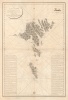
1820 Dépôt de la Marine Nautical Map of the Faroe Islands

This item has been sold.
Plan des íles Ferøë Levé Géométriquement de 1790 à 1795...
First accurate triangulation of the Faroes.
- Digital Map Information
- Suitable for large format printing
- DPI: 600
- File Size: 76.51 MB
- File Type: ZIP / TIFF
- ICC color profile embedded
- Delivered instantly via download link
First accurate triangulation of the Faroes.
This large and striking map is the 1820 French Dépôt des Cartes edition of the seminal 1806 Born survey of the Faroe Islands. This is the first map of the Faroes based on actual triangulation. Although formatted as a nautical chart, the map has little hydrographic detail, with the focus instead being on land-side topography and coastal settlements.Born in the Faroes
While serving the Danish crown as an artillery officer, Christian Ludwig Ulrich von Born was commanded to complete a survey of the previously little known North Atlantic archipelago. This he completed over five years between 1790 and 1795. The Faroes had long proved difficult to survey due to long winters, short summers, and treacherous seas between the many islands. Born completed the survey with land-side triangulation and setting up equipment at high points along the shores. The original manuscript maps, which survive, consisted of seven maps on a uniform scale of 1:72000 and one general map at 1:290000. He was lavish in his depiction of inland landscape detail and even drew stunning cartouches illustrating Faroese life. For unknown reasons, the Danish maritime mapping agency did not publish his charts until 1806. Although examples of the 1806 Danish chart survive, it has no history on the market. This 1820 map issued by the French Dépôt des Cartes et Plans de la Marine is a close copy of the 1806 map and is only known in two examples (including this one).Publication History and Census
This rare map was published by the French Dépôt des Cartes et Plans de la Marine in 1820. It is based upon an earlier chart published in 1806 by the Danish government after the hydrographic of Captain C. L. U. Born. It was engraved by Sébastien-François Bouclet with typography by J.P. Besançon. We note just one other surviving example, at the Bibliothèque Sainte-Geneviève at the Sorbonne in Paris, France.Cartographers
Christian Ludwig Ulrich von Born (1744 - 1805) was a Danish military and naval officer best known for his hydrographic work around the Faroe Islands. Born also served as magistrate of Apenrade, Denmark. Further Details...
Dépôt des Cartes et Plans de la Marine (fl. 1720 - present), often called the Dépôt Général de la Marine, was a French hydrographic mapping organization founded in 1720 under Charles-Hercule of Albert de Luynes (1674 - 1734). Much like the U.S. Coast Survey, the British Admiralty, and the Spanish Deposito Hydrografico, the Dépôt was initiated as a storehouse and distribution center of existing nautical and marine charts. Eventually the Dépôt initiated its own mapping activities in an attempt to improve and expand upon existing material. Some of the more prominent cartographers and hydrographers associated with the of Dépôt Générale des Cartes were, Philippe Buache, Jacques-Nicholas Bellin, Giovanni Rizzi-Zannoni, Rigobert Bonne, and Jean Nicolas Buache. Further Details...
Sébastien-François Bouclet (fl. c. 1800 - 1825) was a French engraver active in Paris in the late 18th and early 19th centuries. He engraved extensively for the Dépôt des Cartes et Plans de la Marine. Among those he taught is the Spanish engraver Felipe Cardano y Bauzá (1778 - 1824). Further Details...
J.P. Besançon (fl. c. 1798 - 1835) was a French engraver who specialized in lettering. Besançon began engraving nautical charts for Charles-François Beautemps-Beaupré (August 6, 1766 - March 16, 1854) in 1802. He engraved 83 maps for Beautemps-Beaupré, then the hydrographer in chief, between 1802 and 1831, when he handed off the work to J.M. Hacq. Little else is known about Besançon's life and career. Further Details...
Condition
Good. Some soiling and wear. Slight loss at fold intersection - patched and stabilized on verso.