
1925 Hagstrom / Dolph Promotional Road Map of Florida, Real Estate Boom


This item has been sold.
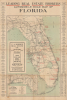
Leading Real Estate Brokers Automobile Road Map of Florida.
Two Pillars of the 1920s Florida Real Estate Boom.
- Digital Map Information
- Suitable for large format printing
- Full resolution TIFF file
- ICC color profile embedded
- Delivered instantly via download link
Two Pillars of the 1920s Florida Real Estate Boom.
This is a c. 1925 Andrew G. Hagstrom large-format promotional map of Florida, published by Frank Dolph. Carefully tracing the state's emerging road and highway network, it also lists the information for several dozen real estate brokers throughout the state. This map is therefore notable for combining two key pillars of the Florida Real Estate Boom and population growth of the 1920s.A Closer Look
This map covers the entire state of Florida, with the western half of the Panhandle included in an inset at the bottom left. Roads of various qualities, railroads, waterways, administrative boundaries, and settlements of various sizes are indicated throughout. Several roads are indicated as proposed, including the Overseas Highway in the Florida Keys and a road between Lake Wales and Vero Beach (now State Route 30). Stretches of hard-surfaced roads have numbers indicating distances between cities and towns.Red overprint highlights the locations of the real estate brokers whose contact information appears in the margins; they are concentrated in Jacksonville, Palm Beach, Miami, and the Tampa Bay region, but are nonetheless distributed throughout the state. A large advertisement appears on the left for the C. A. Roberts Real Estate Company based in Orlando; as was common of such firms, records of this company disappear after 1929 (except for a Florida Supreme Court case adjudicated in 1931).
Florida Land Boom(s)
In the second half of the 19th and throughout the early 20th century, Florida experienced a series of land booms and crashes. The initial land boom established Florida as a center for the citrus industry in the 1880s-1890s, and its collapse made it easy to acquire large tracts of land at cut-rate prices. The state offered railways generous land grants in exchange for laying track, which they could parlay into a cycle of financial benefit as the railways served the new communities their growth enabled. Industrialist and founder of Standard Oil, Henry Flagler (1830 - 1913) seized these opportunities to build his Florida East Coast Railway and extend it to the state's southeastern coast. Henry B. Plant's eponymous system of railroads and steamships accomplished similar results in the Tampa Bay region.Flagler, Plant, and other Florida boosters successfully promoted the state as a paradisical escape from the grimy cities and cold weather of New England and the mid-Atlantic. Land prices shot up at an astronomical rate, and developers carved entirely new cities out of wetlands in mere months. In addition to railways, the arrival of the highway system in the 1920s made the region easier to reach. But speculation in land prices in Florida had reached unsustainable heights, and a delayed realization of 'irrational exuberance,' plus the damage from two hurricanes, followed by the financial crash of 1929, led to a collapse in the real estate market, ruining many investors in the process.
Publication History and Census
A. G. Hagstrom compiled and drew this map in New York, and Frank Dolph published it in St. Petersburg, Florida. It is undated but can be estimated to 1925, at the height of the real estate boom, though it more likely dates to the early part of the decade, as the Overseas Highway is described here as a proposed road rather than complete or under construction. Although a connection between Hagstrom and Dolph was known, with Hagstrom buying some of Dolph's plates in 1916, this map demonstrates a more enduring and complex business relationship that continued even after Dolph relocated to Florida. This map is held in only two institutional collections, at Cornell University and the Touchton Map Library at the Tampa Bay History Center, and has no known market history.Cartographers
Andrew Gunnar Hagstrom (1890 - September 24, 1977) was a map publisher based in Maspeth, Queens. Hagstrom was born in Karleby, Skaraborg, Sweden. He emigrated to New York in 1909, where he took work milking cows at a farm near Coney Island, Brooklyn. He then worked in the meatpacking industry while taking a degree in commercial art at the New York Mechanics Institute. Afterward, he founded a drafting business in Manhattan and created a map to showcase his drafting skill and help customers find his shop. Around 1916, he purchased the copyrights to Dolph & Street Company's base maps of New York City. His maps proved popular, and he expanded operations by founding the Hagstrom Map Company (1916 - 1968) and issuing additional maps of parts of New York City and the surrounding regions. By 1949, Hagstrom had issued more than 150 maps, guides, and atlases, most of which focused on New York. Many of his maps from this period feature a unique dating cipher based on his name (HAGSTROMCX corresponds to the numbers 1-9, with 0 representing the months and years; for example, a map with the code OSO would be 7/47, or July 1947). Hagstrom pioneered a cartographic style that exaggerated street widths to improve clarity and make room for large-print, readable labels. The New York Subway system even hired Hagstrom to produce its map, which was in use from the 1940s to 1958. In 1958, the King of Sweden knighted Hagstrom (Royal Order of Vasa, First Class) for his success in the United States. His company flourished until 1968, when Macmillan acquired it. The brand has since passed through multiple corporate portfolios and is now owned by Kappa Publishing Group. Hagstrom died in 1977 at age 81 in the Virgin Islands. Further Details...
Frank B. Dolph (October 3, 1897 - November 26, 1975) was an American businessman and map publisher. Born in Great Neck, Long Island, New York, Dolph served as a Navy storekeeper during World War I. He began selling maps in 1919 after returning from England, likely for the George F. Cram Company, where he ultimately became an administrative aide. He also worked for the Rand McNally Company for some time before he founded his own map publishing firm, Dolph and Stewart, with his friend, sometime in the 1920s. Dolph and Stewart made maps throughout the 1920s and 1930s until they sold the firm in 1945 when Dolph decided to return to Florida. Dolph opened a new map publishing business, the Frank B. Dolph Map Co. in Ft. Lauderdale and published city plans of cities throughout the United States. Many of his maps were distributed by Chambers of Commerce or sold at newsstands. Real estate developers greatly appreciated his maps, those published by both the Dolph and Stewart Company and the Frank B. Dolph Company. Dolph retired as president of his firm around 1965, when he handed the business off to his son, Frank B. Dolph, Jr. Dolph worked with cartographer Theodore M. Politano for decades while operating the Frank B. Dolph Map Company. Further Details...
Condition
Good. Wear and toning on some old fold lines. A few minor edge repairs. Minor stain in the lower left corner.
References
OCLC 55533797. Touchton Map Library Accession Number: L2018.078.020.