
1910 Saito City Map or Plan of Dalian, China

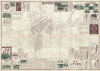

大連市街全圖 / [Complete Street Map of Dalian / Dairen].
Scarce large format map of Dalian, China.
- Digital Map Information
- Suitable for large format printing
- Full resolution TIFF file
- ICC color profile embedded
- Delivered instantly via download link
Scarce large format map of Dalian, China.
This is Saito Katsuzō's unrecorded, large-format 1910 city map or plan of Dalian, or Dairen, documenting the port's early development as Japan's commercial springboard into Manchuria. Published five years after Japan acquired Russia's leasehold rights following the Russo-Japanese War (1904 - 1905), it combines a detailed street and property plan with railway timetables, extensive business advertising, and a photographic panorama on the verso. Its advertisements connect Dalian with businesses in Japan and with inland centers such as Harbin, revealing commercial relationships that extended beyond the boundaries of the Japanese-administered Kwantung Leased Territory, setting the stage for further Japanese expansion into Manchuria in the following years.A Closer Look
The map covers the central city, its harbor and railway installations, and the more sparsely developed districts to the south and west. At its center is the circular Ōhiroba (Ch. Da Guangchang 大廣場), or Great Plaza, now Zhongshan Square. It was originally built in 1898 as Nikolayevskaya Square (Николаевская площадь), or Nicholas II Plaza, when the Russian Empire controlled Dalian (the then Port Arthur, Порт-Артур). From this impressive public space, broad avenues radiate through tightly subdivided blocks, several of them hosting streetcar lines. Individual properties are numbered in considerable detail, while public buildings, commercial premises, schools, hospitals, parks, and industrial establishments are labeled. Columns of business names at left and right, organized by neighborhood and keyed with symbols and numbers, make the plan useful as a commercial directory as well as a street map.The contrast between the dense central neighborhoods and the open peripheral street networks is particularly revealing for expected future development. These radial avenues belong to an urban design established under Russian administration and subsequently developed by the Japanese. Railways organize the northern waterfront, including tracks continuing onto long harbor piers, making the connection between maritime transport and the continental railway system immediately legible. Customs stations, warehouses, railway premises, and waterfront facilities occupy the intervening land.
The South Manchuria Railway Company
Southeast of the Ōhiroba, the South Manchuria Railway Company (南滿鐵道, or Mantetsu for short) headquarters and water-supply grounds appear alongside military and other institutional properties, hinting at its integration with the Japanese government and a much wider network of Japanese businesses. This breadth reflected the company's original mandate; the Japanese government's 1906 organizational orders authorized the South Manchuria Railway Company to undertake mining, water transportation, electrical enterprises, warehousing, and property development, together with engineering, education, and sanitation within its railway lands. The same orders required arrangements for passengers' lodging and meals and for connecting water and land transportation. In brief, as can already be seen here, Mantetsu became a megacorporation for consolidating all of Japan's imperial ambitions in Manchuria, akin in some ways to the British and Dutch East India Companies of earlier centuries. Like the East India Companies, Mantetsu became fantastically wealthy, far larger than any domestic Japanese corporation, and consequently gained outsize political influence.Advertising a Commercial Gateway
Advertisements occupy much of the sheet's perimeter and continue across the verso. Their subjects range from banks, shipping agents, timber merchants, and machinery suppliers to pharmacies, tailors, photographers, curio dealers, and hotels. A large timetable along the lower edge covers both the South Manchuria Railway and the Chinese Eastern Railway (東清鐵道), placing the local street map within a much wider travel network. Several notices make that network unusually explicit. The Toyokan Hotel advertises itself in English as being in Harupin, or Harbin, while the Takahashi Curio Shop addresses English-reading customers interested in paintings, writings, and other curios. Other advertisements name headquarters or branches in Osaka, Kobe, Tokyo, and additional Japanese cities. These notices suggest an audience of merchants and travelers moving between Japan, the leasehold port, and inland Chinese markets. Dalian's importance depended on precisely these connections: the port and railway brought Manchuria's agricultural exports, notably soybeans and their processed products, into overseas trade, while attracting Chinese and Japanese merchants and workers. The advertising presents the services through which that exchange operated.Verso Content
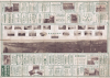
The reverse centers on a broad photographic panorama titled 'Panorama of Dalian' (大連市街全景). Taken from an elevated position, it looks across railway tracks and open ground toward a city of low buildings punctuated by larger institutional structures and industrial chimneys. Smaller photographs above the panorama present street scenes, the South Manchuria Railway premises, the Japanese Bridge, harbor works, railway locomotives, Dalian Hospital, and a night view of 'Electric Park' (電氣公園, now the site of the Dalian Zoo), an amusement park owned and operated by Mantetsu. Together with the surrounding advertisements, these images present Dalian as a working commercial city equipped for visitors, trade, and continued development.Publication History
This map was printed on December 10, 1910 (Meiji 43) and published on December 13, 1910 by Saito Katsuzō (財藤勝藏). Saito is known to have produced an earlier map of Dalian (an example is held by the National Diet Library, OCLC 675647671), which may be an earlier edition, but the large dimensions of the present map suggest considerable differences. Several later maps by other publishers bear the same title as this map, but also differ significantly in both content and dimensions. We have been unable to locate any other examples of the present map in institutional collections or in market history.Cartographer
Saitō Katsuzō (財藤勝藏; fl. c. 1906 - 1928), also written as 戝藤勝藏, was a cartographer and publisher of the late Meiji and Taisho eras based in Osaka. His works aligned perfectly with Japan's growing imperial ambitions at the time, primarily focusing on Korea and Manchuria. He was closely associated with the publishing house Jūjiya (十字屋), of which he may have been a propoerietor. Further Details...
Condition
Very good. Some wear on original fold lines.
References
OCLC 675647671 (potential earlier edition). Hess, Christian A., 'From colonial port to socialist metropolis: imperialist legacies and the making of New Dalian', Urban History, vol. 38, no. 3 (2011), pp. 376 - 377.