
1801 Depot de la Marine Nautical Map of Florida, Cuba, Bahamas, Santo Domingo

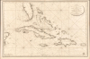
Carte de la Partie Occidentale des Îles Antilles Comprenant St. Domingue, La Jamaique, Cuba et Îles et Bancs de Bahama avec les Débouqumens de toutes ces Îles Dressée d'apres les nouvelles Observations des Espagnols et Publiée Par Ordre du Xontre-Amiral Decrès Ministre de la Marine et des Colonies au Dépôt général de la Marine, en 1801.
At the height of the Haitian Revolution, when a former slave's rise to power that undermined the foundations of the plantation system.
- Digital Map Information
- Suitable for large format printing
- Full resolution TIFF file
- ICC color profile embedded
- Delivered instantly via download link
At the height of the Haitian Revolution, when a former slave's rise to power that undermined the foundations of the plantation system.
A striking 1801 French Dépôt de la Marine nautical chart of Florida and the Greater Antilles, encompassing Cuba, the Bahamas, Hispaniola, Puerto Rico, and Jamaica. Issued at the height of the Haitian Revolution, the map coincides with the rise of the former slave and revolutionary Toussaint Louverture, who had just unified Hispaniola under his authority, sending shockwaves through the slaveholding societies of the Atlantic world. Published as Napoleon Bonaparte prepared his massive Saint-Domingue Expedition to reclaim France's richest colony, this chart reflects the sudden strategic importance of the Caribbean's sea lanes, making it an artifact of one of history's most transformative revolutions.A Closer Look
Centered on Cuba, the map covers from the eastern Yucatan to Puerto Rico and from just north of Cape Canaveral, Florida, to the banks south of Jamaica - thus embracing the most heavily trafficked and contested waters in the West Indies. The work is replete with soundings and shading to indicate navigation hazards- particularly in the Gulf of Mexico west of Florida and the Bahamas. Key anchorages are marked with anchors. The whole is finely engraved, highlighting the technically masterful French Dépôt de la Marine craftsmanship.Historical Context
In 1801 (An X), when the Dépôt de la Marine published this chart, the waters of South Florida and the Greater Antilles had become the focal point of one of the most consequential crises in the Atlantic world. Beginning in 1791, a slave uprising in the French colony of Saint-Domingue evolved into the Haitian Revolution (1791 - 1804), a conflict that shattered the plantation system, drew France, Spain, and Britain into a prolonged struggle, and transformed the Caribbean political landscape. By 1801, the revolutionary leader Toussaint Louverture (1743 - 1803), himself formerly enslaved, emerged as the dominant figure on Hispaniola. An exceptionally skilled military commander and political strategist, Louverture unified the island under his authority and established what was, for all practical purposes, an autonomous state. Although he continued to acknowledge French sovereignty, he maintained his own army, conducted diplomacy, and governed independently of Paris.The rise of Louverture sent shockwaves throughout the Caribbean. The islands depicted here - Cuba, Hispaniola, Jamaica, Puerto Rico, and the Bahamas - were among the most valuable colonies in the world, their economies dependent upon plantation agriculture and enslaved labor. To colonial authorities, the success of a government led by former slaves represented an existential threat. Refugees, merchants, military forces, and political intelligence flowed continuously between the islands, igniting revolutionary fervor throughout the region. Florida, then a lightly governed Spanish possession and a refuge for escaped slaves from the United States, found itself on the northern edge of a world where slaves free themselves and exercise agency.
It was against this backdrop that Napoleon Bonaparte resolved to restore French authority in Saint-Domingue. In late 1801 and early 1802, France assembled an expeditionary force, the Saint-Domingue Expedition, to cross the Atlantic and suppress Louverture's regime. Accurate nautical intelligence became essential, and charts such as this were issued by the French Dépôt de la Marine in anticipation of the expedition. The meticulous treatment of the Bahama Channel, the Florida Straits, Cuba, and the approaches to Hispaniola reflects the growing importance of these sea lanes at a moment when the fate of France's richest colony hung in the balance.
The Best Spanish Source
As suggested by the title, the chart owes its cartography and hydrography to Spanish charts issued immediately prior. We note the distinctive shape of Florida, general toponomy, and meticulous mapping of Cuba and the Bahamas as derivative of an early edition of the Direccion Hidrografía chart, Nueva Carta Del Canal de Bahama.Publication History and Census
This map was first issued in 1801, as here, by the Dépôt de la Marine. There are two 1801 variants: one with the date written as 1801, the other, as here, using the French Republican Calendar and dating it 'An X.' It was engraved by Charles-Étienne Collin and J. P. Besançon. Scarce.Cartographers
Dépôt des Cartes et Plans de la Marine (fl. 1720 - present), often called the Dépôt Général de la Marine, was a French hydrographic mapping organization founded in 1720 under Charles-Hercule of Albert de Luynes (1674 - 1734). Much like the U.S. Coast Survey, the British Admiralty, and the Spanish Deposito Hydrografico, the Dépôt was initiated as a storehouse and distribution center of existing nautical and marine charts. Eventually the Dépôt initiated its own mapping activities in an attempt to improve and expand upon existing material. Some of the more prominent cartographers and hydrographers associated with the of Dépôt Générale des Cartes were, Philippe Buache, Jacques-Nicholas Bellin, Giovanni Rizzi-Zannoni, Rigobert Bonne, and Jean Nicolas Buache. Further Details...
Charles-Étienne Collin (1770 - 1840) was a French engraver active in Paris during the late 18th and early 19th centuries. Collin was born in Paris to a long line of important French engravers dating back to Jean Collin. He was the son of Bernard Collin (1737 - 1791), son of Jean. Collin engraved for the seminal 1809 - 1822 Description de l'Egypte and extensively for the Dépôt de la Marine. He was contracted by his cousin by marriage, Phillipe Buache (1700 - 1773), for his exceptional engraving mastery to work for the Dépôt de la Marine from at least August 1793. He worked with his brother, Jean-Louis Collin (1775 - 1858), from 1800 to 1803. His son, also Charles-Étienne Collin or just Étienne Collin II (1790 - 1852), apprenticed under him and worked with him from 1821 to 1829. Under Charles-Étienne Collin (1770 - 1840) and then his son, the firm was located in Paris at N° 45, Rue de la Harpe - the last known work attributed to 'E. Collin' appeared in 1831. Distinguishing between the 'Collin' family of engravers on Dépôt de la Marine charts is difficult. The elder Étienne Collin (1770 - 1840) typically signed his work 'E. Collin' or later 'E. Collin père'. His son signs some of his work as 'E. Collin' and others as 'C.E. Collin fils.' There is some evidence of another generation of Collin engravers, also Charles-Étienne Collin, signing his work as 'C. E. Collin' between 1840 and 1875. Further Details...
J.P. Besançon (fl. c. 1798 - 1835) was a French engraver who specialized in lettering. Besançon began engraving nautical charts for Charles-François Beautemps-Beaupré (August 6, 1766 - March 16, 1854) in 1802. He engraved 83 maps for Beautemps-Beaupré, then the hydrographer in chief, between 1802 and 1831, when he handed off the work to J.M. Hacq. Little else is known about Besançon's life and career. Further Details...
Condition
Excellent.
References
OCLC 557910605.