
1953 Cheval-Batany Pictorial Wall Map of France (Post-WWII reconstruction)

France.
Rebuilding French national identity and tourism in the post-WWI Era.
- Digital Map Information
- Suitable for large format printing
- Full resolution TIFF file
- ICC color profile embedded
- Delivered instantly via download link
Rebuilding French national identity and tourism in the post-WWI Era.
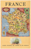
This is a 1953 Jean Cheval and Alex Batany pictorial map of France, issued by the Société Nationale des Chemins de Fer Français (SNCF, or French National Railways in English). The map is a celebration of French culture and reconstruction in the early Postwar period; it depicts no railway lines, rather focusing on cathedrals, vineyards, seaside resorts, and regional specialties, along with reminders of the recent world wars, such as military cemeteries, the Normandy landing beaches, and the burning village of Oradour-sur-Glane.A Closer Look
The map covers mainland France, with Corsica in an inset at the lower left. Rivers and mountain ranges establish the underlying geography, while labels identify dozens of destinations among the illustrations. A red, white, and blue border encloses the composition, echoing the Tricolor. Despite being issued by the SNCF, the map does not trace railway routes; instead, it celebrates France's local history and culture through its products, occupations, and monuments. For instance, Normandy combines dairy farming, Camembert, and seaside holidays. Wine bottles, grapes, and barrels define Champagne, Burgundy, the Loire Valley, and Bordeaux. Hydroelectric installations, aircraft, shipyards, and factories give modern engineering a place beside castles and medieval churches.War remains conspicuous within this holiday landscape. The Normandy coast is marked by Utah Beach, Omaha Beach, Sainte-Mère-Église, and Arromanches. Farther east, rows of crosses mark Verdun, Douaumont, and Montfaucon, while an American flag marks a World War I cemetery. Most arresting is Oradour-sur-Glane, in western France near Limoges, depicted as shattered buildings engulfed in smoke. There, on June 10, 1944, a Waffen-SS unit massacred the village's inhabitants, who were (wrongly) suspected of aiding the French Resistance. Later that year, the French provisional government decided to preserve the village's ruins as a memorial.
The recent wartime destruction is contrasted with signs of France's postwar recovery. In 1946, the SNCF began a major poster campaign encouraging visitors to return to France after World War II. The present poster's multilingual assurance of reliable, comfortable trains addresses both French and foreign travelers. An earlier 1947 edition contained only French and English text, while this edition adds German, evidence of warming Franco-German ties in the face of the Soviet threat. Improved ties between France and Germany had already led to the formation of the European Coal and Steel Community the previous year (1952). They would lead in 1957 to the formation of the European Economic Community, a forerunner to the European Union.
As for English-speakers, in addition to the war memorials, battle sites, and military cemeteries mentioned above, the map also conspicuously includes portraits of explorers Samuel de Champlain and Cavelier de La Salle as well as American Revolution heroes Lafayette and Rochambeau alongside French grandees like Jeanne d'Arc, Louis Pasteur, and Thérèse of Lisieux.
SNCF and the Trente Glorieuses
In the wake of World War II, the Société Nationale des Chemins de fer Français (SNCF) served as a symbol of France's wartime destruction and its Postwar revival. After losing nearly a fifth of its rail network, thousands of bridges, and over 80 percent of its modern locomotives to Allied bombing, German requisitioning, and sabotage, the national railway became a priority under Jean Monnet's postwar modernization plan. Rather than merely rebuilding steam infrastructure in kind, the SNCF aggressively modernized through rapid electrification, including new locomotives such as the CC 7100 class illustrated below the map. These efforts drastically cut capital costs and gained the SNCF international renown. In 1955, SNCF electric locomotives shattered world speed records at 331 km/h, punctuating the transformation of a once-paralyzed network into the technological flagship of French industrial renewal in the span of a decade.Culturally, the SNCF became an emblem of collective recovery and the buoyant optimism of the Trente Glorieuses. Railway workers (cheminots) were lionized as icons of French resistance against the Occupation, a mythos cemented by René Clément's acclaimed 1946 film La Bataille du rail. As the network recovered, prestigious, punctual express trains like Le Mistral and the Train Bleu reimagined domestic travel around speed, comfort, and state-of-the-art design, tightly integrating the provinces with Paris. The railway was not merely a transport utility, but a central civic institution and a democratizing force, embodying a forward-looking republic that linked technological prowess directly to the common good.
Publication History
This poster was designed by Jean Cheval and Alex Batany and printed by the SNCF in 1953, with publicity handled by the advertising firm Yves Alexandre. It is the third issue of the map; the PJ Mode collection at Cornell University holds a 1947 edition with color photographs in the top and bottom margins, while the University of Illinois at Urbana-Champaign and the Library of Congress hold examples dated 1950. Only the David Rumsey Historical Map Collection, the Bibliothèque nationale de France, and Georgetown University hold the present edition.Cartographers
Eugène Joseph Jean Cheval (August 1, 1909 - November 9, 1990), known professionally as Jean Cheval, was a French clown, illustrator, cartoonist, caricaturist, and pictorial map designer based in Paris and active during the mid-20th century. Born in the 18th arrondissement of Paris, Jean's father Léon was a clown, draughtsman, and painter, and Jean followed in his father's footsteps, performing with him while also pursuing evening drawing classes. Jean eventually became part of the artistic milieu of Montmartre. On July 20, 1932, he married Louise Paulette 'Zozo' Poulbot (1912 - 1985), niece of the illustrator Francisque Poulbot (1879 - 1946). He became known as an illustrator in the Interwar period, producing postcards, ranging from serious topics like war and industry to purely humorous and burlesque works.
His cartographic work included collaborations with Alex Batany, signed jointly Cheval-Batany, on illustrated maps promoting French tourism for the Société nationale des chemins de fer français (SNCF). These designs advertised the attractions accessible to railway travelers rather than functioning as conventional railway-route maps. Cheval also illustrated children's coloring books and popular fiction. His publications included Le cirque and L'infanterie française, both issued in Paris by Éditions N. B. in 1945, and cover designs for novels published by Jules Tallandier in 1945 - 1946. He died in the 9th arrondissement of Paris on November 9, 1990.
Further Details...
Alex Batany (fl. c. 1947 - 1953) was a French illustrator and pictorial-map designer active in France during the mid-20th century, particularly through his collaboration with Jean Cheval under the joint signature Cheval-Batany. Their cartographic work included a pictorial tourist map issued by the Société nationale des chemins de fer français (SNCF). Batany and Cheval's joint signature also appears on some contemporary Air France promotional material, including the 1953 leaflet 'Par Air France, vous avez le choix.' Further Details...
Société nationale des chemins de fer français (SNCF; January 1, 1938 - present), known in English as French National Railways, is a French railway organization and corporate publisher of railway and tourist maps, established in Paris and active throughout the 20th and 21st centuries. Its formation followed the convention of August 31, 1937, which brought the principal private railway companies together with the existing state railway administrations under a unified organization. Operations began on January 1, 1938, with the French state holding 51 percent of the company's capital and private shareholders the remaining 49 percent. Its first headquarters occupied the former Paris-Lyon-Méditerranée railway offices at 88 rue Saint-Lazare, Paris. In cartographic publishing, SNCF acted both as an issuing authority and as a collaborator with specialist commercial mapmakers. Its publications included national and European railway maps, regional tourist maps, suburban network plans, and maps of internal administrative and engineering divisions. Reorganized on January 1, 2020, around a parent company and specialized subsidiaries, the SNCF group continues its mapping activities through infrastructure and passenger-service organizations. These activities now include digital cartography: in June 2026, SNCF Connect and Tech introduced Tesmo Maps, combining OpenStreetMap-based mapping with railway routes and points of interest. Further Details...
Condition
Excellent. Mounted on poster linen.
References
Rumsey 13596.000. The PJ Mode Collection, Cornell University, ID 2034.01. (1947 issue). Georgetown University Library, The Train Takes You II: Posters and Pairings for the Virtual Traveler, exhibition checklist entry for France (map), 1953.