
1945 Baker WWII Pictorial Route Map of the Second Armored Division in Europe

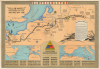
'Hell on Wheels' War Against the Axis 1942 - 1943 - 1944 - 1945.
Second Armored Division at the end of World War II.
- Digital Map Information
- Suitable for large format printing
- Full resolution TIFF file
- ICC color profile embedded
- Delivered instantly via download link
Second Armored Division at the end of World War II.
This is a 1945 Marion E. Baker World War II pictorial campaign route map of the Second Armored Division in Europe and Africa. This map follows the Second Armored Division from its departure from the United States through its July 1945 Berlin occupation duties.A Closer Look
The central map follows the Second Armored Division from Normandy through France and Belgium, across Germany, and to the Elbe River. The Division ended the war in Güterglück, Germany. A bold black line highlights the Division's advance. Cities and towns are labeled along the route, along with rivers, a few forests, and the Siegfried Line. Short captions provide some historical context. A very short caption notes that the Division occupied the American sector in Berlin on July 4, 1945. What the map does not state is that the Second Armored Division was the first American military unit to enter Berlin.A cartouche on the right provides a short history of the Division from its activation at Fort Benning, Georgia, on July 15, 1940, until the end of the war. The inset map on the lower left follows the Division from embarkation in the United States through the Operation Torch landings in North Africa and the Operation Husky landings in Sicily to its transfer to Britain, its arrival on Omaha Beach on June 9, 1944 (three days after D-Day), and its march across Europe. The lower-right inset focuses on North Africa and Sicily. Black lines and arrows show the Division's movements from Morocco through Algeria into Tunisia, then to Sicily. Cities and towns are labeled. The Division insignia sits between the two insets, with the commanding officers' names below. The Division's 7 battle stars are also illustrated here. The names of the major places the Division fought, from Fort Benning, Georgia, to Magdeburg, are listed below both insets. German units the Division fought are listed along the bottom border. The other three borders list the towns and villages the Second Armored encountered, traveled through, fought in, and liberated. It's a stunning visualization of how much ground the Division covered from its arrival in North Africa until it took up occupation duty in Berlin.
Publication History and Census
Marion E. Baker drafted this map in 1945 from data compiled by the Second Armored Division's Intelligence (G-2) Section. It was published after July 4, 1945, likely in Europe. We see examples at Texas A and M University, the Harry S. Truman Library and Museum, the University of Wisconsin-Milwaukee, the Wisconsin Veterans Museum Research Center, and Stanford University.Cartographer
Marion Englebert Baker (February 18, 1922 - October 17, 2000) was an American draftsman and was born in High Springs, Florida. When he registered for the Draft during World War II he was working as a draftsman in the U.S. Engineer's Office in Jacksonville, Florida. He was drafted into the U.S. Army on November 1, 1942, and became a member of the Second Armored Division and worked in the Intelligence section. He eventually rose to the rank of Technician Fourth Grade. Further Details...
Condition
Very good. Wear and light toning along original fold lines. Verso repairs to edge tears. Small closed tears within image professionally repaired on verso.
References
Texas A and M Library G5701.S7 1945 .H45. Rumsey 11212.000. Truman Library M636. OCLC 183883921.