
Batany, Alex
Rebuilding French national identity and tourism in the post-WWI Era.
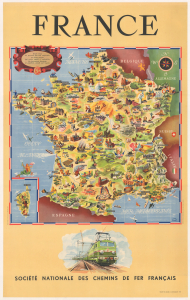
France.
$950.00
Acquire
- Digital Map Information
- Suitable for large format printing
- Full resolution TIFF file
- ICC color profile embedded
- Delivered instantly via download link
This is a 1953 Jean Cheval and Alex Batany pictorial map of France, issued by the Société Nationale des Chemins de Fer Français (SNCF, or French National Railways in English). The map is a celebration of French culture and reconstruction in the early Postwar period; it depicts no railway lines, rather focusing on cathedrals, vineyards, seaside resorts, and regional specialties, along with reminders of the recent world wars, such as military cemeteries, the Normandy landing beaches, and the burning village of Oradour-sur-Glane. (more details)