This item has been sold, but you can get on the Waitlist to be notified if another example becomes available, or purchase a digital scan.
1638 Hondius and Jansson Map of the Straits of Magellan
FretiMagellanici-hondius-1638$450.00

Title
Freti Magellanici ac novi Freti vulgo Le Maire exactissim delineatio.
1638 (undated) 15.5 x 20 in (39.37 x 50.8 cm) 1 : 2050000
1638 (undated) 15.5 x 20 in (39.37 x 50.8 cm) 1 : 2050000
Description
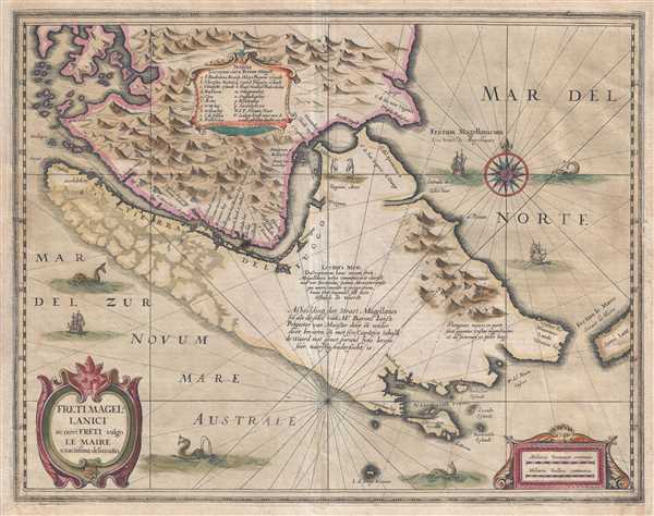
This is a 1638 Jodocus Hondius and Jan Jansson map of the Strait of Magellan and Tierra del Fuego, the southernmost tip of South America from the golden age of Dutch cartography. The map depicts the region from mainland Patagonia to Tierra del Fuego, Cape Horn, and the South Atlantic Ocean. One of the most decorative maps of the Strait of Magellan, Hondius and Jansson must have consulted the most recent data available when creating this map, because several aspects of its cartography are extremely up-to-date. The most compelling addition is the depiction of Tierra de Fuego as an island, which was only confirmed by Admiral Jacques L'Hermite, who was also Dutch, in 1624. Hondius and Jansson also illustrate how the northwestern peninsula of Tierra del Fuego breaks up into islands, another recent discovery. The Le Maire Strait, part of the recently-discovered route around Cape Horn, is also labeled, and provided mariners with another option to the Pacific, instead of the winding and hazardous Strait of Magellan. This route, however, came with its own set of difficulties that plague shipping to this day. Even with the innovations included by Hondius and Jansson, not everything represented here is correct, or even on the right track. For example, one of the many captions includes a reference to Patagonian giants, a mistaken belief that its inclusion only perpetuates.
A table, situated near the top border slightly to the left of center, contains the names of seventeen locations along the Strait of Magellan, and the corresponding locations are identified by letters. Several locations are also noted on the mainland side of the strait. An illustration of two penguins, labeled Pinguini Aves, is included, as are numerous illustrations of galleons and sea monsters in the ocean surrounding Tierra del Fuego. An ornate compass rose is included on the right side of the map, and rhumb lines crisscross the map in multiple directions. A decorative title cartouche is situated in the lower left corner, while another cartouche in the lower right corner contains the scales.
This map was created by Jodocus Hondius and Jan Jansson and published in 1638.
CartographerS
Jodocus Hondius (October, 14 1563 - February 12, 1612) was an important Dutch cartographer active in the late 16th and early 17th centuries. His common name, Jodocus Hondius is actually a Latinized version of his Dutch name, Joost de Hondt. He is also sometimes referred to as Jodocus Hondius the Elder to distinguish him from his sons. Hondius was a Flemish artist, engraver, and cartographer. He is best known for his early maps of the New World and Europe, for re-establishing the reputation of the work of Gerard Mercator, and for his portraits of Francis Drake. Hondius was born and raised in Ghent. In his early years he established himself as an engraver, instrument maker and globe maker. In 1584 he moved to London to escape religious difficulties in Flanders. During his stay in England, Hondius was instrumental in publicizing the work of Francis Drake, who had made a circumnavigation of the world in the late 1570s. In particular, in 1589 Hondius produced a now famous map of the cove of New Albion, where Drake briefly established a settlement on the west coast of North America. Hondius' map was based on journal and eyewitness accounts of the trip and has long fueled speculation about the precise location of Drake's landing, which has not yet been firmly established by historians. Hondius is also thought to be the artist of several well-known portraits of Drake that are now in the National Portrait Gallery in London. In 1593, Hondius returned to Amsterdam, where he remained until the end of his life. In 1604, he purchased the plates of Gerard Mercator's Atlas from Mercator's grandson. Mercator's work had languished in comparison to the rival atlas, Theatrum Orbis Terrarum by Ortelius. Hondius republished Mercator's work with 36 additional maps, including several which he himself produced. Despite the addition of his own contributions, Hondius recognizing the prestige of Mercator's name, gave Mercator full credit as the author of the work, listing himself as the publisher. Hondius' new edition of Mercator revived the great cartographer's reputation and was a great success, selling out after a year. Hondius later published a second edition, as well as a pocket version called the Atlas Minor. The maps have since become known as the "Mercator/Hondius series". Between 1605 and 1610 Hondius was employed by John Speed to engrave the plates for Speed's The Theatre of the Empire of Great Britaine. Following Hondius' death in 1612, his publishing work in Amsterdam was continued by his widow and two sons, Jodocus II and Henricus. Later his family formed a partnership with Jan Jansson, whose name appears on the Atlasas co-publisher after 1633. Eventually, starting with the first 1606 edition in Latin, about 50 editions of the Atlas were released in the main European languages. In the Islamic world, the atlas was partially translated by the Turkish scholar Katip Çelebi. The series is sometimes called the 'Mercator/Hondius/Jansson' series because of Jansson's later contributions. Hondius' is also credited with a number of important cartographic innovations including the introduction of decorative map borders and contributions to the evolution of 17th century Dutch wall maps. The work of Hondius was essential to the establishment Amsterdam as the center of cartography in Europe in the 17th century. More by this mapmaker...
Jan Jansson or Johannes Janssonius (1588 - 1664) was born in Arnhem, Holland. He was the son of a printer and bookseller and in 1612 married into the cartographically prominent Hondius family. Following his marriage he moved to Amsterdam where he worked as a book publisher. It was not until 1616 that Jansson produced his first maps, most of which were heavily influenced by Blaeu. In the mid 1630s Jansson partnered with his brother-in-law, Henricus Hondius, to produce his important work, the eleven volume Atlas Major. About this time, Jansson's name also begins to appear on Hondius reissues of notable Mercator/Hondius atlases. Jansson's last major work was his issue of the 1646 full edition of Jansson's English Country Maps. Following Jansson's death in 1664 the company was taken over by Jansson's brother-in-law Johannes Waesberger. Waesberger adopted the name of Jansonius and published a new Atlas Contractus in two volumes with Jansson's other son-in-law Elizée Weyerstraet with the imprint 'Joannis Janssonii haeredes' in 1666. These maps also refer to the firm of Janssonius-Waesbergius. The name of Moses Pitt, an English map publisher, was added to the Janssonius-Waesbergius imprint for maps printed in England for use in Pitt's English Atlas. Learn More...
Condition
Good. Even overall toning. Wear along original fold lines. Old repairs on verso. Latin text on verso.
References
Koeman 9950:1B. OCLC 276285373.