
1956 Admiralty Nautical Map or Chart of the Galapagos Islands

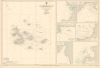
South Pacific Ocean Archipiélago de Colón (Galapagos Islands). 1375.
From Wartime Base to Tourism Boom.
From Wartime Base to Tourism Boom.
This is a 1953 edition British Admiralty nautical chart or map of the Galápagos Islands, Ecuador, updated to 1956. It presents the islands in the post-World War II period, just before the islands became an international tourist destination.A Closer Look
The sheet is divided roughly in half, with the left half presenting the entire archipelago, officially renamed the Archipiélago del Colón by the Ecuadorian government in 1892 to celebrate the 400th anniversary of Christopher Columbus' first Transatlantic voyage. This main chart includes soundings, rocks, hazards, shoals, currents, lights, one manuscript annotation, and a compass rose with magnetic variations. Hachure lines indicate elevation on the islands. A conversion chart for fathoms and a tide chart appear at the bottom-left. On the right side are insets covering Bahia Elizabeth, Villamil, Bahia Academy, Bahia Stephens, Caleta Tagus, and Bahia Wreck, so named for a 1916 shipwreck.From Wartime Base to Tourism Boom
This chart was produced in the aftermath of World War II, when the Galápagos Islands remained a remote outpost, one that had recently seen an influx of American military personnel during World War II. Although Ecuador had incentivized European and, later, U.S. and Ecuadorian migrants to settle on the islands in the 1920s and 1930s, the population remained small, just over 800 in 1941. But during World War II, Ecuador permitted the U.S. to establish a naval base on Baltra Island and radar stations at other strategic locations, as the islands were suitable outposts in the Pacific Ocean and could help protect the Panama Canal. (The reason, no doubt, that 'U.S. Government Charts to 1946' were consulted in the production of the present one.) After the war, the facilities were handed over to the government of Ecuador, and many continue to be used by the Ecuadorian military today.It was some time before the islands became the international tourist destination they are today. The first key step was the establishment of Galápagos National Park in 1959, and the first arrival of a large, dedicated tour ship a decade later. Annual visitors were in the low thousands in the early 1970s but increased steadily to 100,000 in the early 21st century and, in recent years (post-pandemic), more than 300,000, split roughly evenly between Ecuadorians and foreigners.
Publication History and Census
This chart was prepared by the British Admiralty in 1953 and updated to 1956. The OCLC records several editions (with small corrections to the base 1953 edition) at a handful of institutions; we note this 1953 edition only in the holdings of the University of Cambridge and the British Library.Cartographer
The British Admiralty Office (1795 - Present) or the United Kingdom Hydrographic Office refers to the Branch of the English government that is responsible for the command of the British Navy. In 1795 King George III created the United Kingdom Hydrographic Office, known in short as the U.K.H.O., to provide top notch nautical charts to the vast Royal Navy. Prior the founding of the Admiralty the surveying and creation of nautical charts was primarily a commercial venture wherein the cartographer himself, more of than not, actually financed the printing of his own material. The great navigator Cook himself is known to have scrambled for funds to publish his own seminal charts - the most important and advanced of the period. The system of privately funded nautical mapping and publishing left vast portions of the world uncharted and many excellent charts unpublished. King George III, responding significant loss in trade revenue related to shipwrecks and delay due to poor charts, recognized the need for an institutionalized government sponsored cartographic agency - the Admiralty. The first head of the Admiralty, a position known as Hydrographer, was the important cartographer Alexander Dalrymple. Dalrymple started by organizing and cataloging obtainable charts before initiating the laborious process of updating them and filling in the blanks. The first official Admiralty Chart appeared in 1800 and detailed Quiberon Bay in Brittany. By 1808 the position of Hydrographer fell to Captain Thomas Hurd. Hurd advocated the sale of Admiralty charts to the general public and, by the time he retired in 1829, had issued and published some 736 charts. Stewardship of the organization then passed to Rear Admiral Sir Francis Beaufort. It was under Beaufort's administration that the Admiralty truly developed as a "chart making" as opposed to a "chart cataloging" institution. Beaufort held his post from 1829 to 1854. In his 25 years at the Admiralty Beaufort created nearly 1500 new charts and sponsored countless surveying and scientific expeditions - including the 1831 to 1836 voyage of the H.M.S. Beagle. By 1855 the Admiralty's chart catalog listed some 1,981 charts. Further Details...
Condition
Excellent.
References
OCLC 497901844, 49580450.