
This item below is out of stock, but another example (left) is available. To view the available item, click "Details."
Details
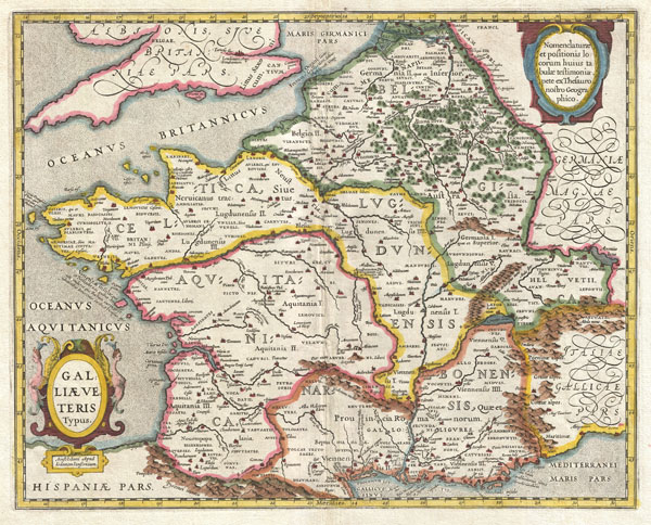
1662 Jansson Map of Ancient Gaul
1636 (undated) $650.00
1657 Jansson Map of France or Gaul in Antiquity
Galliae-jansson-1657$225.00

Title
Galliae Veteris Typus.
1657 (undated) 16 x 20 in (40.64 x 50.8 cm)
1657 (undated) 16 x 20 in (40.64 x 50.8 cm)
Description
This is a remarkable example of Jan Jansson's 1657 mapping of France or Gaul in antiquity. Cartographically this map exhibits heavy influence from a very similar map of the same name published by A. Ortelius in his 1597 Parergon. Based on Greek and Roman sources including Pliny, Strabo, Virgil, Ceasar, and others. A decorative title cartouche depicting curious winged women with exceptionally long necks (harpies?) appears in the lower left quadrant. This remarkable map was published in volume six, the Orbis Antiquus, of Jan Jansson's Novus Atlas.
Cartographer
Jan Jansson or Johannes Janssonius (1588 - 1664) was born in Arnhem, Holland. He was the son of a printer and bookseller and in 1612 married into the cartographically prominent Hondius family. Following his marriage he moved to Amsterdam where he worked as a book publisher. It was not until 1616 that Jansson produced his first maps, most of which were heavily influenced by Blaeu. In the mid 1630s Jansson partnered with his brother-in-law, Henricus Hondius, to produce his important work, the eleven volume Atlas Major. About this time, Jansson's name also begins to appear on Hondius reissues of notable Mercator/Hondius atlases. Jansson's last major work was his issue of the 1646 full edition of Jansson's English Country Maps. Following Jansson's death in 1664 the company was taken over by Jansson's brother-in-law Johannes Waesberger. Waesberger adopted the name of Jansonius and published a new Atlas Contractus in two volumes with Jansson's other son-in-law Elizée Weyerstraet with the imprint 'Joannis Janssonii haeredes' in 1666. These maps also refer to the firm of Janssonius-Waesbergius. The name of Moses Pitt, an English map publisher, was added to the Janssonius-Waesbergius imprint for maps printed in England for use in Pitt's English Atlas. More by this mapmaker...
Source
Jansson, J., Novus Atlas, Sive Theatrum Orbis Terrarum: In quo Orbis Antiquus, Seu Geographia Vetus, Sacra & Profana exhibetur, Volume 6, 1657.
Condition
Very good. Exceptional dark impression. Blank on verso.
References
Keuning, J., 'The Novus Atlas of Johannes Janssonius', Imago Mundi, Vol. 8 (1951), pp. 71-98, no. 422.