
1550 / 1614 Sebastian Münster View of Geneva, Switzerland

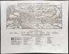
Beyde stett Genff, gross und klein, mit einer Brucken zusammen gehenckt.
Earliest Printed View of Geneva.
- Digital Map Information
- Suitable for large format printing
- Full resolution TIFF file
- ICC color profile embedded
- Delivered instantly via download link
Earliest Printed View of Geneva.
This is an edition of Sebastian Münster's 1550 prospect of Geneva, Switzerland. It presents the first accurate glimpse of the 'Protestant Rome,' the seat of the Reformation in Europe. It is the earliest version of the earliest printed image of Geneva based on actual observation.A Closer Look
This prospect faces south: Lake Geneva (Lemānus) is in the foreground, with the city on its southernmost shore at the mouth of the Rhone River. The Rhone can be seen at the right; its tributary, the Arve, forms the southern limit of the view. The arms of Geneva appear on the left. Features on the view - rivers and important structures, including a plague hospital - are named. Below are translations of the Latin placenames into German. The text below those translations pertains not to the view but to the general section in which it appeared: the Cosmographia included Geneva in the section on France, and the table at the page bottom describes the transmutation of placenames throughout France from Latin into French, including the typical German usage for those places.Possible Sources
The first editions of Münster's view accompanied a text by the Genevan noble, ecclesiastic, historian, and libertine Francois Bonivard (1493 - 1570), and it may be that he provided the view. Bonivard was a prominent scholar and a Libertine, an opponent of John Calvin's efforts to enforce church discipline on Genevan society.Adding to the Cosmographia
From its first printings in 1544, Münster's Cosmographia was notable for maps and views depicting their subjects for the first time in print. In subsequent editions, Münster labored to build the work by ordering improved city views and additional decorative woodcuts. 1550 saw the addition of many maps and views to the body of the work. Münster's spur to do so was the 1548 publication of Johannes Stumpf's magnificently illustrated history of Switzerland, whose woodcut maps and views outstripped those in Cosmographia both in quality and number. Münster knew he had to improve and commissioned many of the woodcuts that would make his work the most popular. This was among the first to be added. The view, dated 1548, bears the symbol (although not the full monogram) of formschneider Hans Rudolf Manuel Deutsch (1525 - 1571). Many of Deutsch's woodcuts were first included in the 1550 editions of Münster's work.Publication History and Census
This woodcut was executed by the artist Hans Rudolf Manuel Deutsch, who carved many of Munster's woodcuts, including his famous panoply of monsters. It was produced for inclusion in the 1550 edition of Münster's Cosmographia, and it remained in the work for the rest of its long publication run. The present example conforms typographically to the 1614 German-text edition of Cosmographey. Five separate examples are listed in OCLC, but the work appears on the market from time to time.Cartographers
Sebastian Münster (January 20, 1488 - May 26, 1552), was a German cartographer, cosmographer, Hebrew scholar and humanist. He was born at Ingelheim near Mainz, the son of Andreas Munster. He completed his studies at the Eberhard-Karls-Universität Tübingen in 1518, after which he was appointed to the University of Basel in 1527. As Professor of Hebrew, he edited the Hebrew Bible, accompanied by a Latin translation. In 1540 he published a Latin edition of Ptolemy's Geographia, which presented the ancient cartographer's 2nd century geographical data supplemented systematically with maps of the modern world. This was followed by what can be considered his principal work, the Cosmographia. First issued in 1544, this was the earliest German description of the modern world. It would become the go-to book for any literate layperson who wished to know about anywhere that was further than a day's journey from home. In preparation for his work on Cosmographia, Münster reached out to humanists around Europe and especially within the Holy Roman Empire, enlisting colleagues to provide him with up-to-date maps and views of their countries and cities, with the result that the book contains a disproportionate number of maps providing the first modern depictions of the areas they depict. Münster, as a religious man, was not producing a travel guide. Just as his work in ancient languages was intended to provide his students with as direct a connection as possible to scriptural revelation, his object in producing Cosmographia was to provide the reader with a description of all of creation: a further means of gaining revelation. The book, unsurprisingly, proved popular and was reissued in numerous editions and languages including Latin, French, Italian, and Czech. The last German edition was published in 1628, long after Münster's death of the plague in 1552. Cosmographia was one of the most successful and popular books of the 16th century, passing through 24 editions between 1544 and 1628. This success was due in part to its fascinating woodcuts (some by Hans Holbein the Younger, Urs Graf, Hans Rudolph Manuel Deutsch, and David Kandel). Münster's work was highly influential in reviving classical geography in 16th century Europe, and providing the intellectual foundations for the production of later compilations of cartographic work, such as Ortelius' Theatrum Orbis Terrarum Münster's output includes a small format 1536 map of Europe; the 1532 Grynaeus map of the world is also attributed to him. His non-geographical output includes Dictionarium trilingue in Latin, Greek, and Hebrew, and his 1537 Hebrew Gospel of Matthew. Most of Munster's work was published by his stepson, Heinrich Petri (Henricus Petrus), and his son Sebastian Henric Petri. Further Details...
Heinrich Petri (1508 - 1579) and his son Sebastian Henric Petri (1545 – 1627) were printers based in Basel, Switzerland. Heinrich was the son of the printer Adam Petri and Anna Selber. After Adam died in 1527, Anna married the humanist and geographer Sebastian Münster - one of Adam's collaborators. Sebastian contracted his stepson, Henricus Petri (Petrus), to print editions of his wildly popular Cosmographia. Later Petri, brought his son, Sebastian Henric Petri, into the family business. Their firm was known as the Officina Henricpetrina. In addition to the Cosmographia, they also published a number of other seminal works including the 1566 second edition of Nicolaus Copernicus's De Revolutionibus Orbium Coelestium and Georg Joachim Rheticus's Narratio. Further Details...
Hans Rudolf Manuel Deutsch (1525–1571) was a Swiss artist and woodcutter. His work appeared in Agricola's De re metallica and for Sebastian Münster's Cosmographia. Deutsch's father, Niklaus Manuel Deutsch (the Elder) and his brother Niklaus were also artists. Further Details...
Source
Münster, S., Cosmographey, (Basel: Petri) 1614.
The Cosmographia Universalis, one of the greatest geographical and historical works of the 16th century, 'taught nearly three generations of laymen most of what they knew about the world beyond their native places' (Strauss). Filled with maps, views, and rich descriptions of places throughout Europe and beyond, it was the best general source of geographical information until the advent of Ortelius' Theatrum. It was first issued by Sebastian Munster (1488 - 1552) in its 1544 German edition, and stayed in print long after its author's death in thirty-five editions, and five languages. (Of these, the 1550 and 1552 editions are widely regarded as the most complete and truest to the author's intentions; thereafter, later editors continued to add to the work's text; editions from 1588 onwards employed an entirely different set of maps produced on Ortelius' model.) Munster's goal, initially, was to rally his homeland's humanists and scholars to produce a new map of Germany in order to 'see what kind of a land our ancestors conquered for their home... bring honor to our country and place its beauties in the clear light of day.' Munster's project quickly expanded to cover the known world in its scope to produce a 'sufficiently large volume, in which I touch upon the foundation of all nations and kingdoms, their peculiarities, rivers, mountains, customs of men, royal successions, origins of the more important cities, succinct histories, religions, characteristics and fertility of lands... in Germany, however, I tarry a little longer'. Munster's methodology in Cosmographia is notable in particular for his dedication to providing his readers with direct access to firsthand reports of his subjects wherever possible. Many of the maps were the result of his own surveys; others, the fruit of an indefatigable letter-writing campaign to scholars, churchmen, and princes throughout Europe, amicably badgering them for maps, views, and detailed descriptions of their lands. For lands further afield than his letters could reach, Munster relied on the best that the authorities of northern European scholarship could offer: he was well familiar with the work of Waldseemuller and other geographers of the early 16th century and was well connected with the best geographers of his own generation. A disproportionate number of the maps of Cosmographia show contemporary geographical knowledge of their respective areas for the very first time: The first map to show the continents of the Western Hemisphere; the first map to focus on the continent of Asia; the first modern map to name the Pacific Ocean; the first map to use a key; the first modern map of the British Isles and so on. Even in cases where earlier maps exist, Munster's works very often remain the earliest such acquirable by the collector.
Condition
Excellent, with generous margins.
References
OCLC 216917097. (1574)