Digital Image: 1854 Blake Geological Route Map of the American West: Mississippi River to Los Angele
Geological-blake-1854_d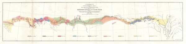

Title
Geological Map of the Route Explored by Lieut. A. W. Whipple, Corps of Topographical Engineers near the parallel of 35 degrees North Latitude from the Mississippi River to the Pacific Ocean. 1853-1854.
1854 (dated) 9 x 38 in (22.86 x 96.52 cm) 1 : 3000000
1854 (dated) 9 x 38 in (22.86 x 96.52 cm) 1 : 3000000
Description
FOR THE ORIGINAL ANTIQUE MAP, WITH HISTORICAL ANALYSIS, CLICK HERE.
Digital Map Information
Geographicus maintains an archive of high-resolution rare map scans. We scan our maps at 300 DPI or higher, with newer images being 600 DPI, (either TIFF or JPEG, depending on when the scan was done) which is most cases in suitable for enlargement and printing.
Delivery
Once you purchase our digital scan service, you will receive a download link via email - usually within seconds. Digital orders are delivered as ZIP files, an industry standard file compression protocol that any computer should be able to unpack. Some of our files are very large, and can take some time to download. Most files are saved into your computer's 'Downloads' folder. All delivery is electronic. No physical product is shipped.
Credit and Scope of Use
You can use your digial image any way you want! Our digital images are unrestricted by copyright and can be used, modified, and published freely. The textual description that accompanies the original antique map is not included in the sale of digital images and remains protected by copyright. That said, we put significant care and effort into scanning and editing these maps, and we’d appreciate a credit when possible. Should you wish to credit us, please use the following credit line:
Courtesy of Geographicus Rare Antique Maps (https://www.geographicus.com).
How Large Can I Print?
In general, at 300 DPI, you should at least be able to double the size of the actual image, more so with our 600 DPI images. So, if the original was 10 x 12 inches, you can print at 20 x 24 inches, without quality loss. If your display requirements can accommodate some loss in image quality, you can make it even larger. That being said, no quality of scan will allow you to blow up at 10 x 12 inch map to wall size without significant quality loss. For more information, it is best consult a printer or reprographics specialist.
Refunds
If the high resolution image you ordered is unavailable, we will fully refund your purchase. Otherwise, digital images scans are a service, not a tangible product, and cannot be returned or refunded once the download link is used.
Cartographer S
William Phipps Blake (June 1, 1826 – May 22, 1910) was an American geologist, mining consultant, and educator. Blake has been credited with being 'the first college trained chemist employed full-time in American industry' before graduating from Yale. Selected as the mineralogist and geologist of the Pacific Railroad Exploring Expedition in 1853, Blake made several important discoveries, including studying the erosive effects of wind-blown sand in San Gorgonio Pass in California. Several of the sketches he produced for the Railroad Survey reports are not highly sought after as works of art. Over the course of his career, Blake served in several different official government posts, including as the California representative to the Exposition Universelle in Paris in 1867 and to collect and install the mineral exhibit at the Philadelphia Centennial Exposition. Blake also became a sought-after expert witness for testimony in court cases involving the geology of mineral deposits. His final stop in a long an illustrious career was at the University of Arizona, where he served as a Professor of Geology and as Director of the School of Mines. More by this mapmaker...
August Hoen and Company (fl. c. 1840 - 1981) was a Baltimore based engraving and lithography firm active in the middle part of the 19th century. A. Hoen and Co. was originally founded by Edward Weber under the name 'E. Weber and Company.' Weber died in the early 1850s and his company was taken over by German immigrant August Hoen (18?? - 1886) and his brothers, Henry and Ernest Hoen. As general interest lithographers, the Hoen firm's corpus includes posters, cigar boxes, sheet music covers, and posters as well as maps. They are best known for their pioneering multi-color lithographic techniques. After the death of August Hoen, the business passed on to his son, Albert Hoen. Another son, Earnest A. Hoen, moved to Richmond, Virginia and opened a branch of the firm there where he was granted a charter to produce Civil War era Confederate Currency. Their contributions to the cartographic field are generally in association with engraving and printing work done for Jacob Monk and the U.S. Geological Survey. The Hoen family maintained an active interest in the firm for the next 100 years or so until it finally filed for bankruptcy in 1981. Learn More...
References
OCLC 53803051.