
1943 Sundberg Map of the World at War During World War II

This item has been sold.
Global War.
World War II as of mid-October 1943.
Choose a Collection:
- Digital Map Information
- Suitable for large format printing
- Full resolution TIFF file
- ICC color profile embedded
- Delivered instantly via download link
This Item
Enquire
World War II as of mid-October 1943.
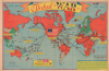
This is a 1943 Edwin Sundberg pictorial map of the world illustrating the contemporaneous state of the ongoing World War II (1939 - 1945). Sundberg highlights the far-flung places where American soldiers are occupying, fighting, and dying, and expertly uses color to emphasize the major theaters of combat as of mid-October 1943.A Closer Look
With the United States at the center, the map depicts the state of World War II in mid-October 1943. A huge American flag covers most of the United States and part of Canada. Countries shaded red are the 'United Nations and Occupied Areas', while countries shaded green are the 'Axis Nations and Occupied Areas'. Significantly, Italy is striped, highlighting ongoing fighting. New Guinea is also both red and green, illustrating its status as an active war zone. China is also both colors; combat in China began in 1937, two years before Hitler invaded Poland.Orange lines connect American ports (New York, San Francisco, and Seattle), with outlying battlefronts in Europe, North Africa, the Middle East, and the Pacific. (The routes from Seattle are to Dutch Harbor and Kiska in Alaska. The Japanese bombed Dutch Harbor and occupied Kiska from June 1942 until July 1943.) Travel times are provided in days. Blue lines generally illustrate aviation routes to Europe, North Africa, the Middle East, and the Pacific. Travel times by air are given in hours. Significantly, a road connects Seattle with Alaska. That highway was completed in 1942. Soldiers mark the countries and provinces where U.S. troops are stationed, and the date of the first American arrival in each location is provided. Stars mark American naval bases. Three of these, Guam, Wake Island, and Manila, are green, highlighting that they are occupied by the Japanese.
Publication History and Census
This map was drawn by Edwin L. Sundberg and published by the Sunday News on October 17, 1943. This is the only known cataloged example.Cartographer
Edwin L. Sundberg (1898 - 1978) was an American cartographer known for his pictorial pieces. Sundberg was a staff artist for the Sunday News in New York City and eventually became Chief Cartographer in charge of a small staff of artists. Further Details...
Source
Sunday News, October 17, 1943.
Condition
Very good. Newsprint. Verso repairs to fold separations. Closed edge tears professionally repaired on verso. Two half-inch vertical tears within the printed image perpendicular to the horizontal centerfold professionally repaired on verso.