
1945 Van Swearingen Map of Central Luzon, Philippines, and MacArthur's March on Manila

This item has been sold.
MacArthur's March On Manila.
Liberating Manila.
- Digital Map Information
- Suitable for large format printing
- Full resolution TIFF file
- ICC color profile embedded
- Delivered instantly via download link
Liberating Manila.
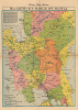
This is a 1945 E.C. Van Swearingen map of central Luzon, illustrating the World War II Philippine Campaign and the American retaking of the Philippines. It was published by the Chicago Daily Tribune on February 2. The march on Manila served as the prelude to the Battle of Manila, one of the Pacific War's most destructive battles.A Closer Look
The map depicts central Luzon from Balaoan and Kiangan south to Corregidor Island at the mouth of Manila Bay. Prominent blue arrows mark the U.S. landing at Lingayen Gulf on January 9, 1945. Dashed lines follow the American advance south from Lingayen Gulf and illustrate the battle lines as of January 14, January 21, and January 30. The second American landing at San Antonio and San Narcisco is also noted. Blue airplane silhouettes mark airfields. Cities and towns are identified, and railroads and main and secondary highways are illustrated. Provinces are labeled.The Philippine Campaign
Launched on October 20, 1944, the Philippine Campaign was a World War II joint American/Filipino military operation intended to liberate the strategic archipelago from occupying Imperial Japanese forces. The Japanese Army overran most of the Philippines during the first half of 1942, retaining it for the subsequent 2 years. American General Douglas MacArthur began the campaign by announcing on Philippine radio 'This is the Voice of Freedom, General MacArthur speaking. People of the Philippines: I have returned.' The campaign progressed rapidly, driving the Japanese out of one island after another. Although by this time the Japanese were clearly losing the war, they gave no sign of capitulation and refused to surrender. During the campaign, Japan suffered nearly half a million casualties compared to only about 50,000 Americans. The campaign continued until Japanese forces in the Philippines were ordered to surrender by Tokyo on August 15, 1945, after the dropping of atomic bombs on Hiroshima and Nagasaki.Publication History and Census
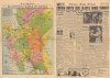
This map was drawn by E.C. Van Swearingen and published in the Chicago Daily Tribune on February 2, 1945. We note an example cataloged in OCLC, which is part of the collection at the Wisconsin Veterans Museum Research Center. We also note one example in private hands.Cartographer
Earl Cornelius Van Swearingen (April 2, 1904 - February 27, 1992) was an American graphic artist. Born in New Cumberland, West Virginia, Van Swearingen worked as an artist for newspapers throughout the 1930s and 1940s, working for the Associated Press for at least some time in the 1930s. Very little is known about his education or career. He married his wife Phyllis Marguarite Van Swearingen on May 18, 1925, in the family home in Canton, Ohio. They had three children. Van Swearingen and his wife moved to Cape Coral, Florida, in 1969, where he became a well-known yachtsman, celebrated by the yachting community in Cape Coral well into his 80s. Further Details...
Source
Chicago Daily Tribune, February 2, 1945.
Condition
Very good. Newsprint. Closed edge tears professionally repaired on verso.
References
OCLC 825780643.