This item has been sold, but you can get on the Waitlist to be notified if another example becomes available, or purchase a digital scan.
1893 Britton and Rey Map of Golden Gate Park, San Francisco
GoldenGatePark-brittonrey-1893$550.00

Title
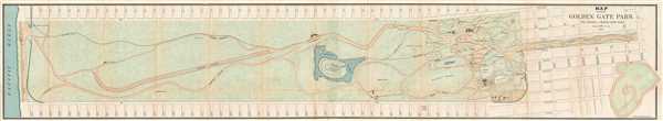
Map Showing the Golden Gate Park, the Avenue, and Buena Vista Park
1893 (dated) 9.5 x 53 in (24.13 x 134.62 cm) 1 : 4818
1893 (dated) 9.5 x 53 in (24.13 x 134.62 cm) 1 : 4818
Description
This is an 1893 Joseph Britton and Jacques Joseph Rey map of Golden Gate Park. The map depicts Golden Gate Park from the Pacific Ocean to Baker Street and from D Street to H Street and includes both The Panhandle and Buena Vista Park. When compared with later editions of maps of Golden Gate Park, this example illustrates a park that is relatively undeveloped. The eastern side of the park, near The Panhandle, is crisscrossed by walking paths and drives. It houses a buffalo paddock, a deer glen, a peacock valley, a conservatory, casino, and auditorium. Meanwhile, the further west one moves through the park, 'improvements' become sparser. Even some of the walkways and drives are marked as 'proposed.' Golden Gate Park was founded in the 1870s, thus the relative lack of development throughout the entire park is not astonishing. The map itself is highly detailed. Each of the avenues is labeled, along with various sites situated around the park. Within the park, the walks, drives, and attractions are labeled.
This map was produced by Britton and Rey Lithographers in San Francisco in 1893.
This map was produced by Britton and Rey Lithographers in San Francisco in 1893.
CartographerS
Joseph Britton (1825 - July 18, 1901) was born in Yorkshire, England, and immigrated to the United States in 1835 with his family, living in New York City, becoming a lithographer by 1847. In 1849, he left New York to seek his fortune in California during the California Gold Rush. He made the journey with George Gordon’s ‘Gordon’s California Association’, and chose the voyage which included an overland trek via Nicaragua. The voyage was supposed to last 60 days, but instead lasted an incredible 8 months. After several unsuccessful years in various gold mining camps, Britton relocated to San Francisco and established a lithography firm, probably in 1851, and then entered into a short-lived collaboration with C.J. Pollard in 1852, named Pollard and Britton. By late 1852, Britton had formed a partnership with the lithographer Jacques Joseph Rey. Rey married Britton’s sister in 1855, but Britton remained a life-long bachelor and lived with the Rey family. Rey and Britton were well integrated into San Francisco. They owned a plumbing and gas-fitting firm, which apparently Rey managed. They also worked with several different lithographers off and on, but their partnership solidified by 1867. Britton was one of the three original investors in Andres Hallidie’s first San Francisco cable-car line on Clay Street and served twice as a San Francisco City and County Supervisor. More by this mapmaker...
Jacques Joseph Rey (1820 - 1892) was born in Bouxwiller, Alsace, France, and apparently was trained in art and lithography. Around 1850, he immigrated to California. Rey, a lithographer by training, entered into a partnership with Joseph Britton (1825 - 1901) by late 1852. Rey married Britton’s sister in 1855, but Britton, who remained a life-long bachelor, lived with the newlyweds. Rey and Britton were well integrated into San Francisco. They owned a plumbing and gas-fitting firm, which apparently Rey managed. They also worked with several different lithographers off and on, but their partnership solidified by 1867. Following Rey’s death and Britton’s retirement, Rey’s son, Valentine J. A. Rey, took over the business and ran it at least until the 1906 San Francisco earthquake and fire. Learn More...
Britton and Rey (1852 - 1906) was a lithographic firm based in San Francisco founded by Joseph Britton (1825 - 1901) and Jacques Joseph Rey (1820 - 1892). The leading firm in the area during the second half of the 19th century, Britton and Rey eventually earned the reputation of being the western Currier and Ives. They published both large-format and postcard views of California, as well as with stock certificates, stationery, and maps. Within the partnership, Rey was the artist and Britton the principal lithographer. Britton was also principally concerned with the business aspects of the firm. The firm also printed lithographs by other artists, including Thomas Almond Ayres (1816 - 1858), George Holbrook Baker (1824 - 1906), Charles Christian Nahl (1818 - 1878), and Frederick August Wenderoth (1819 - 1884). After Rey's death in 1892 and Britton's subsequent retirement, the firm passed to Rey's son, Valentine J. A. Rey, who ran the firm until at least the 1906 San Francisco earthquake and fire. A. Carlisle and Company, another San Francisco printer, acquired the remains of the Britton and Rey firm in 1916. For more information about Joseph Britton and Jacques Joseph Rey, please reference their individual biographies included in our cartographer database. Learn More...
Source
Board of Supervisors, San Francisco Municipal Reports for the Fiscal Year 1892 - 93, ending June 30, 1893, (San Francisco: Board of Supervisors) 1893.
Condition
Good. Backed on archival tissue for stability. Blank on verso.