
This item below is out of stock, but another example (left) is available. To view the available item, click "Details."
Details
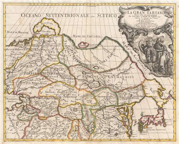
1693 Cantelli da Vignola Map of the Tartar Empire
1693 (dated) $950.00
1693 Cantelli da Vignola Map of Northeastern Asia or Grand Tartary
GranTartaria-vignola-1693$625.00

Title
La Gran Tartaria.
1693 (dated) 17.5 x 22 in (44.45 x 55.88 cm) 1 : 15000000
1693 (dated) 17.5 x 22 in (44.45 x 55.88 cm) 1 : 15000000
Description
A stunning 1693 map of northeast Asia, or as it was then known, Gran Tartaria by Giacomo Cantelli da Vignola. The map covers northeastern Asia from the Caspian Sea to the Japanese Kurile Islands, and from Nova Zembla to Tibet. The map is derived from the work of Melchisédech Thévenot and Jean-Baptiste Tavernier compiled by Giacomo de Rossi. The focus of the map is the lands to the north of China from whence came the Mongol Hordes, a subject of fascination and horror for Europeans who remembered the unstoppable 13th century invasions of Poland and Hungary. A stylized Mongol equestrian warrior, reimagined on a European model, appears prominently in the title cartouche.
Cartographically the map offers much of interest, from a dramatically elongated Korean peninsula, to a novel mapping of the Gobi Desert and the Great Wall of China. Major Chinese cities are recognizable, including Nanjing and Peking (Beijing), among others. In Tibet, Lhasa is noted. Similarly, further west, important centers of the Silk Route, including Samarkand, Kashgar, Lahore, and Bokhara are identified. Nova Zembla, in the far north, is attached to the Russian mainland, doubtless in recognition of near impenetrable ice flows in the region. Hokkaido is erroneously connected to the mainland of Asia. The Japanese Kurile Islands are mapped as enormous landmasses based upon the mistaken impression of Dutch navigators Maerten de Vries and Cornelis Jansz Coen. North of Hokkaido, the southern arms of Sakalin are recognizable, but the northeastern outcropping of Asia is entirely absent.
This map was published by Giacomo Cantelli da Vignola and engraved by Giovanni Giacomo de Rossi for publication in the 1693 edition of the Mercurio Geografico.
CartographerS
Giacomo Cantelli da Vignola (February 22, 1643 - November 30, 1695) was an important Italian cartographer and engraver active in 17th century Italy. Cantelli was born in Montorsello, near Vignola, Italy to a prominent local family. After studying literature at the University of Bologna, Cantelli took a position as secretary to the Marquis Obizzi de Ferrara. Eventually Cantelli relocated to Venice where he developed an interest in cartography. He later traveled to Paris in the company of the French ambassador where became acquainted with the French cartographer Guillaume Sanson, as well as his contemporaries Jacques-Andre Duval and Michel-Antoin Baudrand. It was most likely the influence of these innovative French cartographers that inspired Cantelli's careful and meticulous approach, in which he based his cartography not just on earlier maps, but also very much in the French style upon accounts written by travelers and merchants regarding actual travel to foreign lands. Back in Italy, Cantelli took service with Count Rinieri Marescotti, with whom he traveled extensively throughout Italy, becoming in the process acquainted with the Italian publisher Giovanni Giacomo de Rossi. It is with Rossi that Cantelli began officially publishing his maps. The earliest maps to bear the Cantelli-Rossi imprint date to 1672 and detail the Holy Land, Persia, and the Ottoman Empire. Around 1680 the duo also began to publish the Mercurio Geografico, a large format atlas illustrating all parts of the world in a splendid Italian baroque detail defined by elaborate finely engraved cartouche work, high quality paper, bold Roman lettering, and dark rich inks. Some have compared his style go that of Giovanni Antonio Magini, another Italian cartographer of the previous generation. Cantelli da Vignola in fact pioneered the Italian style of fine bold engraving that would eventually be embraced and expanded upon by Vincenzo Coronelli. His work drew the attention of Pope Innocent XI and Reggio Francesco II d'Este, the Duke of Modena, both of whom offered him a position as court geographer. Cantelli chose to work with the Duke of Modena, in the service of whom he produced numerous maps and well as two large globes. He died in Modena in November 1695. More by this mapmaker...
Giovanni Giacomo de Rossi (1627 - 1691) was an Italian engraver and printer, active in Rome during the second half of the 17th century. His father, Giuseppe de Rossi (1570 - 1639), was the founder of the most important and active printing press of the 17th century in Rome. The printing press was begun in 1633, by Giuseppe de Rossi, and it passed firstly to Giovanni Giacomo and to his brother Giandomenico (1619 - 1653), and then later to Lorenzo Filippo (1682-?), then Domenico de Rossi (1659 - 1730). Giovanni Giacomo de Rossi was most active between 1638 and 1691 and was to take the company to the height of its success. The artists that he printed the etchings for included Giovanni Benedetto Castiglione (1609 - 1665), Pietro Testa (1612-1650), and Giovan Francesco Grimaldi (1606 – 1680). Cartographically he is best known for producing the maps of Giacomo Cantelli da Vignola and publishing them in his c. 1683 Mercurio Geografico. In 1738 the firm became the Calcografia Camerale, from 1870 until 1945 the Regia Calcografica, and today it is known as the Calcografia Nazionale. The Calcografia Nazionale holds is one of the finest collections of early printing plates and prints in the world. Learn More...
Source
da Vignola, Giacomo Cantelli, Mercurio Geografico, (Rome: Rossi) 1693.
Condition
Very good. Slight wear on original centerfold. Else fine.
References
OCLC 875641631.