1693 Cantelli da Vignola Map of the Tartar Empire
Tartaria-cantellirossi-1693$950.00

Title
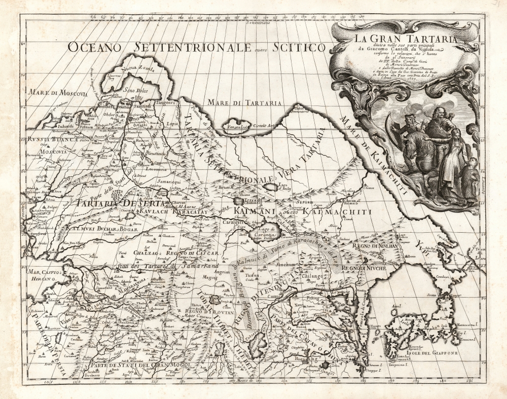
La Gran Tartaria.
1693 (dated) 16.75 x 21.25 in (42.545 x 53.975 cm) 1 : 15000000
1693 (dated) 16.75 x 21.25 in (42.545 x 53.975 cm) 1 : 15000000
Description
This is Cantelli da Vignola's 1693 map of Central and northeastern Asia. It embraces Asia from the Caspian Sea eastwards to the Kuril Islands, and from the Mogul Empire of Northern India to the Arctic. It focuses primarily on Tartar lands, spanning from the Russian frontier to the Great Wall of China.
Thus, Cantelli faced the task of presenting the up-to-date travelers' reports of the Mogul Empire, and its trade connections to China and Central Asia, but reconciling that new information with the maps of established authorities like Martini and Sanson, along with the reports of Dutch explorers. By placing the new information in the context of earlier works, Cantelli produced a map of even broader interest
Far to the north, Nova Zembla appears as not an island but a peninsula, perhaps taking a pessimistic view of reports of ice-bound channels.
In the east, not only are Martini's China, Japan, and Korea included, but also Staten Island and Van Compagnies' Land (here named Terra di Iesso). These derive from the 1643 explorations of Maerten de Vries and Cornelis Jansz Coen, who explored the coast of Sakhalin - here attached to the Yupi peninsula. The islands extending to the northeast likely represent Vries and Coen’s discovery of the Japanese Kuril Islands of Kunashir and Iturop (Terra di Iesso). The Asian Pacific coast north of the Yupi Peninsula appears to be drawn largely from Jaillot's 1674 map of Asia (which indeed may be the channel by which the Martini geography came to the present work.)
An Array of Sources
Cantelli credits three sources in his cartouche: The Jesuit Society and the Monsieurs Tavernier and Thévenot. The former certainly included Martino Martini, whose rendition of Japan is reproduced here; the rendition of China and Korea is also reminiscent of his work. Of the latter two, the first is certainly the famed gem merchant and traveler Jean-Baptiste Tavernier, who long traveled in the east and published his travels in 1677. The second is Jean Thévenot, who also ventured east and who in 1664 and 1665 accompanied Tavernier on his travels. Thévenot's journeys were published posthumously in 1674. Thévenot's travels were confined to the Mogul Empire in the south. However, his last two voyages had secured the gem trader extraordinary knowledge of Eastern trade routes and close correspondence with Oriental potentates. The two travelers' accounts represented some of the most up-to-date information available to a mapmaker in the early 1680s. Likely this work's novel mapping of the Gobi Desert and the Great Wall of China come from these contemporary travelogues. Likewise, important centers of the Silk Route, including Samarkand, Kashgar, Lahore, and Bokhara are identified.Thus, Cantelli faced the task of presenting the up-to-date travelers' reports of the Mogul Empire, and its trade connections to China and Central Asia, but reconciling that new information with the maps of established authorities like Martini and Sanson, along with the reports of Dutch explorers. By placing the new information in the context of earlier works, Cantelli produced a map of even broader interest
Far to the north, Nova Zembla appears as not an island but a peninsula, perhaps taking a pessimistic view of reports of ice-bound channels.
In the east, not only are Martini's China, Japan, and Korea included, but also Staten Island and Van Compagnies' Land (here named Terra di Iesso). These derive from the 1643 explorations of Maerten de Vries and Cornelis Jansz Coen, who explored the coast of Sakhalin - here attached to the Yupi peninsula. The islands extending to the northeast likely represent Vries and Coen’s discovery of the Japanese Kuril Islands of Kunashir and Iturop (Terra di Iesso). The Asian Pacific coast north of the Yupi Peninsula appears to be drawn largely from Jaillot's 1674 map of Asia (which indeed may be the channel by which the Martini geography came to the present work.)
Warriors of Tartaria
Widman's beautifully engraved cartouche paints a vivid picture of a Tartar warrior society which had long struck fear into European readers. A chieftain on horseback peers at the reader; beyond him is a fierce, braided foot soldier. In the foreground, a fur-clad child gazes up at his mother, who points at the fearsome pair as if to say 'this is what to be when you grow up.'Publication History and Census
This map is among those engraved by Giorgio Widman in 1683 for inclusion in Cantelli's Mercurio Geografico, published in Rome by Giacomo de Rossi. We are aware of two states of this map, the 1683 and this second 1693 issue. We see only ten examples listed in OCLC.CartographerS
Giacomo Cantelli da Vignola (February 22, 1643 - November 30, 1695) was an important Italian cartographer and engraver active in 17th century Italy. Cantelli was born in Montorsello, near Vignola, Italy to a prominent local family. After studying literature at the University of Bologna, Cantelli took a position as secretary to the Marquis Obizzi de Ferrara. Eventually Cantelli relocated to Venice where he developed an interest in cartography. He later traveled to Paris in the company of the French ambassador where became acquainted with the French cartographer Guillaume Sanson, as well as his contemporaries Jacques-Andre Duval and Michel-Antoin Baudrand. It was most likely the influence of these innovative French cartographers that inspired Cantelli's careful and meticulous approach, in which he based his cartography not just on earlier maps, but also very much in the French style upon accounts written by travelers and merchants regarding actual travel to foreign lands. Back in Italy, Cantelli took service with Count Rinieri Marescotti, with whom he traveled extensively throughout Italy, becoming in the process acquainted with the Italian publisher Giovanni Giacomo de Rossi. It is with Rossi that Cantelli began officially publishing his maps. The earliest maps to bear the Cantelli-Rossi imprint date to 1672 and detail the Holy Land, Persia, and the Ottoman Empire. Around 1680 the duo also began to publish the Mercurio Geografico, a large format atlas illustrating all parts of the world in a splendid Italian baroque detail defined by elaborate finely engraved cartouche work, high quality paper, bold Roman lettering, and dark rich inks. Some have compared his style go that of Giovanni Antonio Magini, another Italian cartographer of the previous generation. Cantelli da Vignola in fact pioneered the Italian style of fine bold engraving that would eventually be embraced and expanded upon by Vincenzo Coronelli. His work drew the attention of Pope Innocent XI and Reggio Francesco II d'Este, the Duke of Modena, both of whom offered him a position as court geographer. Cantelli chose to work with the Duke of Modena, in the service of whom he produced numerous maps and well as two large globes. He died in Modena in November 1695. More by this mapmaker...
Giovanni Giacomo de Rossi (1627 - 1691) was an Italian engraver and printer, active in Rome during the second half of the 17th century. His father, Giuseppe de Rossi (1570 - 1639), was the founder of the most important and active printing press of the 17th century in Rome. The printing press was begun in 1633, by Giuseppe de Rossi, and it passed firstly to Giovanni Giacomo and to his brother Giandomenico (1619 - 1653), and then later to Lorenzo Filippo (1682-?), then Domenico de Rossi (1659 - 1730). Giovanni Giacomo de Rossi was most active between 1638 and 1691 and was to take the company to the height of its success. The artists that he printed the etchings for included Giovanni Benedetto Castiglione (1609 - 1665), Pietro Testa (1612-1650), and Giovan Francesco Grimaldi (1606 – 1680). Cartographically he is best known for producing the maps of Giacomo Cantelli da Vignola and publishing them in his c. 1683 Mercurio Geografico. In 1738 the firm became the Calcografia Camerale, from 1870 until 1945 the Regia Calcografica, and today it is known as the Calcografia Nazionale. The Calcografia Nazionale holds is one of the finest collections of early printing plates and prints in the world. Learn More...
Giorgio Widman (fl. 1672 to 1682) was a celebrated map and lettering engraver, who worked primarily with the De Rossi publishing house. He is perhaps best known for having executed the lettering of Giovanni Battista Falda's superb 1675 map of Rome. Learn More...
Jean-Baptiste Tavernier (1605 - 1689) was a French gem merchant, traveler, and adventurer active in India and East Asia in the middle part of the 17th century. Tavernier was born in Paris of a French or Flemish Huguenot family that had emigrated to Antwerp, to escape persecution, and which subsequently returned to Paris after the publication of the Edict of Nantes, which promised protection for French Protestants. Tavernier had a family connection to mapmaking as both his father Gabriel and his uncle Melchior were cartographers and engravers. Nonetheless, despite a natural talent for drawing and engraving, he had an insatiable wanderlust and instead traveled independently to India and Asia where he made his fortune in the gem trade. Tavernier made a total of six voyages to Persia, India, and Asia between 1630 and 1668. Tavernier is best known for the discovery/purchase of the 116-carat Tavernier Blue diamond that he subsequently sold to Louis XIV of France in 1668 for 120,000 livres, the equivalent of 172,000 ounces of pure gold, and a letter of ennoblement. (Five years later, Louis had his court jeweler Jean Pitau recut the stone into the 68 carat French Blue and had it set as a hatpin. The gem was reset by his great-grandson Louis XV in The Medal of The Order of the Golden Fleece, stolen in 1792, and was recut and re-emerged in London 30 years later as The Hope Diamond). A wealthy man from his adventures, Tavernier acquired the Barony of Aubonne, and settled into a life of leisure wherein, to occupy himself he published a narrative of his voyages, along with two maps, as Les Six Voyages de Jean-Baptiste Tavernier (1676). Tavernier died in Moscow in 1689, at the age of eighty-four. There is a persistent and most likely false legend that he died from being torn apart by wild dogs as a result of a curse on the Tavernier Blue (Hope Diamond). He one of three brothers of the French merchant adventurer Daniel Tavernier who also made numerous voyages to East Asia. Learn More...
Jean de Thévenot (1633 - 1667) was a French traveller who wrote extensively about his journeys. He was also a linguist, natural scientist and botanist. He was born in Paris to a noble family, the nephew of Melchisédech Thévenot, with whom he is often confused. He traveled extremely broadly, visiting England, the Netherlands, Germany and Italy. From Rome in 1655 he sailed to Malta, and then to Constantinople. From there in 1657 he ventured around the Greek Islands and then on to Egypt and Sinai. He made the Lent pilgrimage from Cairo to Jerusalem by caravan, visited holy sites in Palestine, and sailed the Mediterranean - several times taken by pirates, and involved in fights with Spanish corsairs.
In 1663, he traveled again to the east. This time, after stops in Egypt ans Palestine he proceeded east to Mosul, Baghdad and Mendeli. In 1664 he traveled Persia in the company of the gem merchant and traveler Jean-Baptiste Tavernier, attempting to find practicable land routes to India in order to circumvent the Dutch hold on the east. After parting ways with Tavernier, he stayed for more than a year in the Mughal Empire
Like his uncle, Thévenot was an accomplished linguist, skilled in Turkish, Arabic and Persian, and skilled in the natural sciences. Also, he wrote accounts of his travels: his first journey was published in 1665, and his later voyages were published posthumously in 1674 and 1684. Learn More...
Source
da Vignola, Giacomo Cantelli, Mercurio Geografico, (Rome: Rossi) 1693.
Condition
Excellent. Few faint spots, else fine with a bold strike.
References
OCLC 875641631. Rumsey 11438.157.