
1714 Hermann Moll Map of Scotland

This item has been sold.
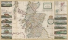
The North Part of Great Britain Called Scotland.
Promoting exploiting Scottish fisheries and forests.
- Digital Map Information
- Suitable for large format printing
- Full resolution TIFF file
- ICC color profile embedded
- Delivered instantly via download link
Promoting exploiting Scottish fisheries and forests.
This is a stunning old color example of Herman Holl's 1714 map of Scotland promoting the dynamic utilization of Scotland's rich natural resources, including leveraging Scottish fisheries and forests to reduce British dependence on imports.A Closer Look
Coverage embraces Scotland from Faro Head south to Cumberland and Durham, England. Counties are highlighted in outline color, with cities, towns, lochs, and rivers labeled. The Outer Hebrides are identified as the Western Islands. Moll includes several historical notes commenting on Loch Ness, Stornway Castle, and St. Ouran's Church on Iona Island. Views of Aberdeen, Edinburgh Castle, Sterling, St. Andrews, Glasgow, and Edinburgh appear along the left and right borders.A Political Map
Below the title cartouche, Moll statesIts manifest by this Map, which is founded upon undoubted Authority, how easy it would be to settle the most advantageous Fishery in the world here, and also with a small charge to make Rivers navigable, for Carrying timber to the Seas side, for there grows excellent good Fir etc. in these parts, so that if things were rightly managed, there would be no occasion to go to Norway for Wood or to New-found-land for fish; seeing North Britain can Plentifully furnish us with both.In keeping with this observation/criticism, Moll marks fisheries around the Outer Hebrides, known to be rich in cod, ling, and herring. He also notes mineral resources on the Isle of Skye and the springs in Peterhead.
Publication History and Census
This map was created and published by Herman Moll in 1714. The map appears in approximately one dozen institutional collections cataloged in OCLC, spread across over half a dozen entries in that database.Cartographer
Herman Moll (1654 - 1732) was an important 18th century map publisher and engraver based in London and Holland. Moll's origins are disputed with some suggesting he was born in the Netherlands and others Germany - the Moll name was common in both countries during this period. Most likely Moll was a German from Bremen, as his will, friends, and contemporaries suggest. What is known for certain is that he moved to London in 1678, possibly fleeing the Scanian War, where he worked as an engraver for Moses Pitt and other London map publishers. Around the turn of the century, Moll set up his own shop where he produced a large corpus of work known for its high quality and decorative flair. As a new émigré to England, Moll made himself more English than the English, and through his cartography proved a fierce advocate for his adopted nation. Most of Moll's early maps were issued as loose sheets that would be bound to order, however, he did publish several important atlases late in his career. Moll is said to have made the bold claim that without a doubt "California is an Island" and that he "had in [his] office mariners who have sailed round it." While California may not be an island (yet), it is true that Moll had talent for attracting interesting friends and acquaintances. He frequented London's first stock exchange, Jonathan's Coffeehouse at Number 20 Exchange Alley, Cornhill. At the time Jonathan's was known as "a place of very considerable concourse for Merchants, sea faring Men and other traders" (Erleigh, The Viscount, The South Sea Bubble, Manchester: Peter Davies, Ltd., 1933, 21). Eventually this activity attracted the interest of stock brokers, who inspired by sailor's tales, sponsored the ill-fated South Sea Company, the world's first stock bubble. Moll's close circle, mostly from the Coffee House, included scientist Robert Hooke, the writers Daniel Defoe (Robinson Crusoe) and Jonathan Swift (Gulliver's Travels), the pirates William Dampier, William Hacke and Woodes Rogers, and the archeologist William Stukeley. Herman Moll's work was highly regarded for its decorative beauty and was pirated, most notably by the Irish publisher George Grierson, both in his lifetime and after his 1732 death at St. Clement Danes, London. Further Details...
Source
Moll, H., The World Described; or a New and Correct Sett of Maps, (London) 1711-33.
Herman Moll's The World Described; or a New and Correct Sett of Mapps Shewing the Several Empires, Kingdoms, Republics, Principalities, Provinces etc. in all Known Parts of the World is the most English atlas of the early 18th century, both for its cartographic content and for its unusual and evolving publication history. First issued c. 1715, the atlas was not conceived as a single, fixed-volume publication, but rather as a composite work assembled over time, reflecting the dynamic and commercial nature of the London map trade. Moll issued the atlas in parts, with new maps engraved, updated, and added incrementally across multiple printings extending to about 1754 (well after Moll's 1732 death). The earliest iterations of The World Described emerged during a period of intense interest in geography, trade, and imperial expansion. Moll capitalized on this demand by producing large, separately issued maps that could be sold individually or collected into bound atlases according to a purchaser's preference. As a result, no single 'standard' collation of the atlas; instead, surviving examples vary in content and arrangement. The maps themselves often bear the imprint 'Sold by H. Moll over against Devereux Court in the Strand,' and many are dated between roughly 1715 and the early 1720s, though dates are frequently absent, complicating bibliographic reconstruction. The World Described includes Moll's most influential maps, including large-format representations of North America, the Caribbean, and the British colonies. These maps are notable for their political and commercial emphasis, highlighting English territorial claims and trade routes. Moll's work also drew upon contemporary sources, including information from explorers, merchants, pirates, and private correspondents, lending the atlas both topical relevance and a degree of authority. Following Moll's death in 1732, the atlas passed into the hands of other London publishers, who continued to issue updates. Among these were Thomas Bowles, John Bowles, and later Robert Sayer. These publishers reissued Moll's plates, sometimes with updated imprints or minor revisions, extending the life of the atlas into the 1750s. There is also a famous pirated edition of The World Described issued in Dublin by George Grierson.
Condition
Very good. Bright old color. Light wear along original fold lines. Verso repair to a fold separation.
References
OCLC 165798742. Boston Public Library, Leventhal Map Center, #G1015 .M65 1709.