This item has been sold, but you can get on the Waitlist to be notified if another example becomes available, or purchase a digital scan.
1745 Buache/ De l'Isle Map of Greece and Turkey
Greece-buache-1745$225.00


Title
Carte De La Grece...
1745 (dated) 18 x 25.5 in (45.72 x 64.77 cm) 1 : 2200000
1745 (dated) 18 x 25.5 in (45.72 x 64.77 cm) 1 : 2200000
Description
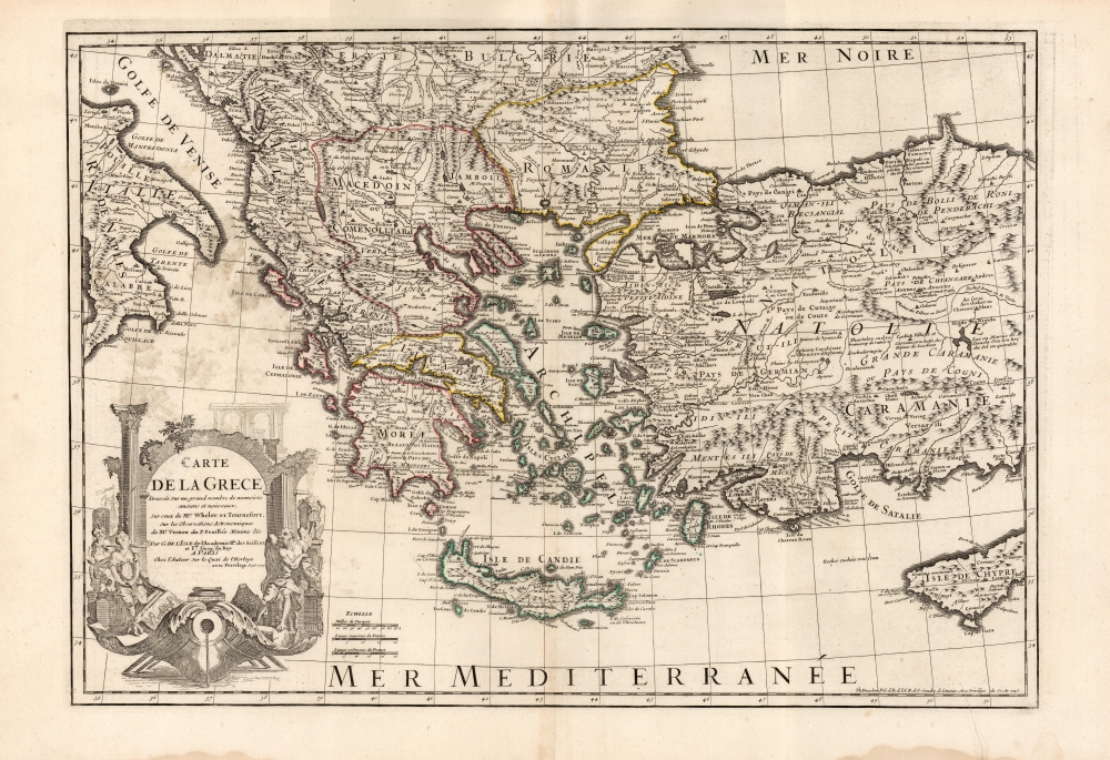
This is the 1745 Buache edition of Guillaume De l'Isle's 1707 map of Greece and the western part of Turkey. It presents the region at the beginning of a period of Greek revolts against Ottoman rule.
Geographical Scope
The map reaches from the boot of Italy to the western part of Cyprus; and as far north as the Dalmatian coast and Bulgaria, and beyond the island of Crete in the south. Albania, Macedonia (inclusive of Greek Macedonia), and Romania are included.The Cartouche
This allegorical cartouche was superbly engraved by Nicolas Guérard. It evokes the ruin and waste of the centuries-long conflict between the Ottoman Empire and the West. A rowing galley sits at anchor in the foreground, but beyond this, the image is framed with ruined, classical arches. To the right, an elderly, winged man - Father Time - leans exhaustedly on a broken vase, with coins spilling out. A broken statue stands in the background. To the left, a woman sits with a painting discarded at her feet - this may be Clio, the muse of History. Her eyes are cast heavenward, and her hands patiently folded - but she wears a yoke on her shoulders. The yoke is marked with a crescent, symbolizing the Ottoman Empire - as does the turbaned gentleman with his hand on the other end of the yoke.Publication History and Census
This map was produced by Guillaume De l'Isle 1707 as a separate issue. It would later be included in his atlases, and those of his heirs. This is an example of the 1745 issue printed by Philippe Buache, De l'Isle's son-in-law. In its various editions, this map is well represented in institutional collections, albeit with a broad range of imprecise dating.CartographerS
Guillaume De l’Isle (1675 - 1726) was a French cartographer, and arguably the finest mapmaker at the beginning of the eighteenth century. He was the son of Claude De L'Isle (1644 -1720), a Paris-based historian and geographer under Nicholas Sanson, then the leading light of French cartography. He was the chief proponent of the school of 'positive geography' and the primary figure defining the heights of the Golden Age of French Cartography. Guillaume's skill as a cartographer was so prodigious that he drew his first map at just nine years of age. He was tutored by J. D. Cassini in astronomy, science, mathematics and cartography. By applying these diverse disciplines to the vast stores of information provided by 18th century navigators, Guillaume created the technique that came to be known as 'scientific cartography', essentially an extension of Sanson's 'positive geography'. This revolutionary approach transformed the field of cartography and created a more accurate picture of the world. Among Guillaume's many firsts are the first naming of Texas, the first correct map of the Mississippi, the final rejection of the insular California fallacy, and the first identification of the correct longitudes of America. Stylistically De L'Isle also initiated important changes to the medium, eschewing the flamboyant Dutch style of the previous century in favor of a highly detailed yet still decorative approach that yielded map both beautiful and informative. Guillaume was elected to the French Academie Royale des Sciences at 27. Later, in 1718, he was also appointed 'Premier Geographe du Roi', an office created especially for him. De L'Isle personally financed the publication of most of his maps, hoping to make heavy royalties on their sales. Unfortunately he met an untimely death in 1728, leaving considerable debt and an impoverished child and widow. De L'Isle's publishing firm was taken over by his assistant, Phillipe Buache, who would also become his son in law. More by this mapmaker...
Phillipe Buache (February 7, 1700 - January 24, 1773) was a late 18th century French cartographer and map publisher. Buache began his cartographic career as the workshop assistant and apprentice to the important and prolific cartographer Guillaume de L'Isle. Upon De L'Isle's untimely death, Buache took over the publishing firm cementing the relationship by marrying De L'Isle's daughter. Over the years, Bauche republished many of De L'Isle's maps and charts. Buache was eventually appointed Premier Geographe du Roi, a position created-for and previously held by Guillaume de L'Isle. Buache is most respected for his introduction of hachuring as a method from displaying underwater elevation on a two dimensional map surface. Buache compiled maps based upon geographic knowledge, scholarly research, the journals of contemporary explorers and missionaries, and direct astronomical observation. Nevertheless, even in 18th century Paris geographical knowledge was severely limited - especially regarding those unexplored portions of the world, including the poles, the Pacific northwest of America, and the interior of Africa and South America. In these areas the Buache, like his primary rival Robert de Vaugondy, must be considered a speculative geographer or 'positive geographer'. Speculative geography was a genre of mapmaking that evolved in Europe, particularly Paris, in the middle to late 18th century. Cartographers in this genre would fill in unknown areas on their maps with speculations based upon their vast knowledge of cartography, personal geographical theories, and often dubious primary source material gathered by explorers and navigators. This approach, which attempted to use the known to validate the unknown, naturally engendered many rivalries. Buache's feuds with other cartographers, most specifically Didier Robert De Vaugondy, resulted in numerous conflicting papers being presented before the Academie des Sciences, of which both were members. The era of speculatively cartography effectively ended with the late 18th century explorations of Captain Cook, Jean Francois de Galaup de La Perouse, and George Vancouver. Buache was succeeded by his nephew Jean-Nicholas Buache de Neuville. Learn More...
Condition
Very good. One mended tear to lower right, with no loss. Original outline color.
References
OCLC 907808927. This variant not in Zacharakis or Rumsey.