
1852 Logerot Pictorial City Plan or Map of Paris, France

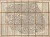
Nouveau Plan ou Guide de l'Étranger dans Paris.
Paris the year before the Haussmann renovations.
- Digital Map Information
- Suitable for large format printing
- Full resolution TIFF file
- ICC color profile embedded
- Delivered instantly via download link
Paris the year before the Haussmann renovations.
This is Auguste Logerot's 1852 pictorial city plan or map of Paris, published on the eve of the Haussmann Renovations. Pictorial illustrations highlight monuments, landmarks, and other important buildings, including the Palais du Louvre, Notre Dame de Paris, the Palais du Luxembourg, the Arc de Triomphe, and the Hotel des Invalides. Paris's celebrated gardens, including the Tuileries, the Champ de Mars, and the Jardin des Plantes are illustrated and labeled. Hand coloring highlights the city's twelve arrondissements. A street index occupies the left and right borders.Haussmannization or the 'Grands Travaux'
This map was published just before the 'Grand Traveaux', the transformation of Paris by Emperor Napoléon III and Baron Georges-Eugène Haussmann, began. Completed between 1853 and 1870, the renovation of Paris consisted of the demolition of medieval neighborhoods that were deemed overcrowded and unhealthy; the building of wide avenues; new parks and squares; the annexation of the suburbs surrounding Paris; and the construction of new sewers, fountains, and aqueducts. Known in French as the 'Grands Travaux,' Haussmann's redesign of Paris defined it as a modern city, with narrow alleyways and confusing streets replaced by a broad network of grand boulevards, imposing facades, parks, and monuments. Some of the more famous parts of Paris today, including the famous design of Étoile, where the Arc de Triomphe is located, were constructed during Haussmann's tenure as Prefect.Publication History and Census
This map was created by Auguste Logerot, and engraved by Charles Dyonnet. The monuments were drawn by Thénot and engraved by Duchez. The map was published by Logerot in 1852. We note a single cataloged example, at the Bibliothèque nationale de France.Cartographers
Auguste Logerot (fl. c. 1839 - c. 1880) was a French map and general interest publisher active throughout the mid to late 19th century. A. Logerot worked with other French publishers, cartographers and engravers of the period including Fremin, Dufour, Dyonnet, and Vuillemin. He published a large corpus of map and geographical atlases, though few of his map represented unique or exceptionally interesting work. This exception are his wonderful jigsaw puzzle maps - a style popular in 19th century France. Jigsaw puzzle maps are a kind of educational map printed on board and carved up in puzzle format. Logerot's imprint is frequently misprinted as Lagerot or Logeret. Logerot shared offices with several other publishers, printers and engravers at Quai des Augustins 55, Paris. Little else is known of Logerot's life and work. Further Details...
Charles Dyonnet (fl. c. 1822 - c. 1880) was an extremely active Paris based engraver working in the mid to late 19th century. From his offices at 220 Rue St. Jacques, Paris, Dyonnet engraved numerous maps for many of the most prominent 19th French cartographic publishers including Vuillemin, Dufour, Fremin and Duvotenay. From 1850-1861, he held the coveted position of "Graveur du Dépot de la Marine," and in this position engraved numerous French naval and military maps. Dyonnet had a detail oriented and aesthetically minded hand and is responsible from some of the most beautiful French maps to emerge during the 19th century. Further Details...
Condition
Very good. Dissected and mounted on linen in twenty-one (21) panels. Slight loss to linen at a few fold intersections.
References
OCLC 887563212.