1606 Hondius Map of West Africa South of the Niger River
Guinea-hondius-1606$550.00

Title
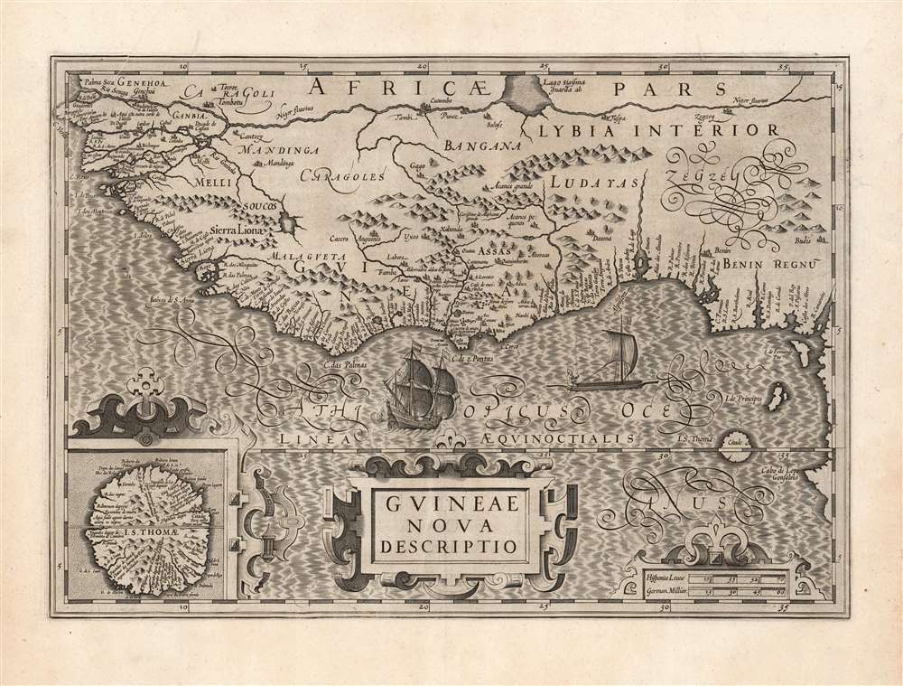
Guineae Nova Descriptio.
1606 (undated) 13.75 x 19.5 in (34.925 x 49.53 cm) 1 : 7500000
1606 (undated) 13.75 x 19.5 in (34.925 x 49.53 cm) 1 : 7500000
Description
This is Jodocus Hondius' 1606 map of the Guinea coast of Africa, stretching from the mouth of the Senegal River to Cape Lopez, from modern Senegal to Benin. It shows this coast at a time when its trade was largely controlled by the Portuguese, with whom the Dutch were at war; this map thus presented to a Dutch audience what would have been considered a rich prize to be taken.
A Superb Engraving
The engraving of this map displays the high standard of Hondius' work. Mountains and water areas feature bold hachure. The lettering is sharp and legible, not only in its fine Italics but also the elaborate calligraphy, most notably the riotous flourishes announcing 'Zegzey' north of the kingdom of Benin. A native sailing canoe is contrasted agasint a European galleon, firing cannon. Strapwork designs set off the title cartouche, the scales, and the inset map of São Tome.The Portuguese Foothold in Africa
The notations here are in Portuguese. The inland notation of 'Corisseno de Aliphante grande' (District of large elephants) appears to derive from a 1602 map by the Portuguese Jesuit Luis Teixeira, and it is likely that Hondius' other details hail from the same source. The Portuguese established trading factories along this coast to export ivory (hence 'de Aliphante grande'), gold, and increasingly, enslaved Africans. Among the installations marked along the coast is the infamous Castel de la Mina, a transshipment entrepôt for Africans captured and enslaved throughout the Slave Coast of Benin.São Tome
The importance of this island off the coast of Benin is emphasized by the inclusion of the detailed inset map. The Portuguese settlers established sugar plantations there, and imported enslaved Africans from the mainland to operate them due to Sickle cell trait (SCT) making them more resistant to malaria. Some trace the Portuguese efforts to establish viable sugar plantaios on São Tome as the origins of chattel slavery. By the middle of the 16th century São Tome had become Africa's primary exporter of sugar. The inset map marks the island's primary settlement, but also sugar mills and plantations.Publication History and Census
This map was engraved for inclusion in Jodocus Hondius' 1606 Atlas, among the maps he produced to supplement those he acquired from Mercator. It would remain in the Hondius atlases until about 1639, at which time it was supplanted by a more modern map engraved by Jansson. The verso text of the present example conforms typographically to the 1630 Latin edition of Henry Hondius' Atlas, editio decima. In its various editions, this map is well represented in institutional collections. Two of this specific edition are listed in the University of Bern and the Herzogin Anna Amalia Bibliothek Klassik.CartographerS
Jodocus Hondius (October, 14 1563 - February 12, 1612) was an important Dutch cartographer active in the late 16th and early 17th centuries. His common name, Jodocus Hondius is actually a Latinized version of his Dutch name, Joost de Hondt. He is also sometimes referred to as Jodocus Hondius the Elder to distinguish him from his sons. Hondius was a Flemish artist, engraver, and cartographer. He is best known for his early maps of the New World and Europe, for re-establishing the reputation of the work of Gerard Mercator, and for his portraits of Francis Drake. Hondius was born and raised in Ghent. In his early years he established himself as an engraver, instrument maker and globe maker. In 1584 he moved to London to escape religious difficulties in Flanders. During his stay in England, Hondius was instrumental in publicizing the work of Francis Drake, who had made a circumnavigation of the world in the late 1570s. In particular, in 1589 Hondius produced a now famous map of the cove of New Albion, where Drake briefly established a settlement on the west coast of North America. Hondius' map was based on journal and eyewitness accounts of the trip and has long fueled speculation about the precise location of Drake's landing, which has not yet been firmly established by historians. Hondius is also thought to be the artist of several well-known portraits of Drake that are now in the National Portrait Gallery in London. In 1593, Hondius returned to Amsterdam, where he remained until the end of his life. In 1604, he purchased the plates of Gerard Mercator's Atlas from Mercator's grandson. Mercator's work had languished in comparison to the rival atlas, Theatrum Orbis Terrarum by Ortelius. Hondius republished Mercator's work with 36 additional maps, including several which he himself produced. Despite the addition of his own contributions, Hondius recognizing the prestige of Mercator's name, gave Mercator full credit as the author of the work, listing himself as the publisher. Hondius' new edition of Mercator revived the great cartographer's reputation and was a great success, selling out after a year. Hondius later published a second edition, as well as a pocket version called the Atlas Minor. The maps have since become known as the "Mercator/Hondius series". Between 1605 and 1610 Hondius was employed by John Speed to engrave the plates for Speed's The Theatre of the Empire of Great Britaine. Following Hondius' death in 1612, his publishing work in Amsterdam was continued by his widow and two sons, Jodocus II and Henricus. Later his family formed a partnership with Jan Jansson, whose name appears on the Atlasas co-publisher after 1633. Eventually, starting with the first 1606 edition in Latin, about 50 editions of the Atlas were released in the main European languages. In the Islamic world, the atlas was partially translated by the Turkish scholar Katip Çelebi. The series is sometimes called the 'Mercator/Hondius/Jansson' series because of Jansson's later contributions. Hondius' is also credited with a number of important cartographic innovations including the introduction of decorative map borders and contributions to the evolution of 17th century Dutch wall maps. The work of Hondius was essential to the establishment Amsterdam as the center of cartography in Europe in the 17th century. More by this mapmaker...
Henricus Hondius II (1597 – August 16, 1651) was a Dutch engraver, cartographer and publisher. The son of the cartographer Jodocus Hondius, Henricus took over the business after father died in 1612, co-ran the business with his brother Jodocus II. In 1628 Henricus partnered with Jan Janssonius and together they continued the business, with Jansson’s name appearing on the Atlasas co-publisher after 1633. Eventually, about 50 editions of the Atlas were released in the main European languages. In the Islamic world, the atlas was partially translated by the Turkish scholar Katip Çelebi. The series is sometimes called the 'Mercator/Hondius/Jansson' series because of Jansson's later contributions. Learn More...
Luís Teixeira (1564 - 1604) was a Portuguese Jesuit cartographer, and mathematician. He had two sons, also cartographers. Little is known of his life and education, but he would be highly placed: he became cartographer to the Spanish Crown. His work would be widely disseminated, especially in the maps of Ortelius, Hondius and their successors. His map of Japan, published by Ortelius, would be the first detailed separate map of the island. His charts also informed the mapping of Brazil, and of the African coast. Learn More...
Source
Hondius, H., Atlas, editio decima, (Amsterdam: Hondius) 1630.
Mercator's Atlas is one of the most important works in the history of cartography. Although in fact Ortelius was the first to publish a proper atlas, the Teatrum Orbis Terrarum, Mercator's work the first book to employ the term Atlas for a collection of maps. The term is derived both from the mythical titan, Atlas, who was forced to bear the world upon his shoulders, and the Libyan king, philosopher, and astronomer of the same name that, so the legend goes, constructed the first globe. Mercator dedicated the final 25 years of his life to compile the Atlas. He published two parts during his lifetime in 1585 and 1589, but the final part published posthumously by his son Rumold Mercator, in 1595. The map plates for the Atlas were later acquired by Jodocus Hondius who published the most complete and well known edition in 1606. It was Jodocus who popularized the Atlas and who did the most to elevate Gerard Mercator's name.
Condition
Very good. Wide margins and a bold strike; few filled wormholes with some reinstatement of image. Centerfold reinforced.
References
Rumsey 10501.463. Norwich, O., Maps of Africa, #316.