
1942 Pictorial View of the Hajj Sacred Sites, Mecca

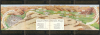
رسم مشاعر الحج : نقلا عن كتاب مراة الحرمين لأمير الحج اللواء ابراهيم رفعت باشا / [Depicting the Emotions of Hajj: Excerpted from the book Mir'at al-Haramayn by the Commander of the Hajj Caravan, Major General Ibrahim Rifaat Pasha].
Ornate Wartime Bird's-Eye View of Mecca.
$6,000.00
Choose a Collection:
- Digital Map Information
- Suitable for large format printing
- Full resolution TIFF file
- ICC color profile embedded
- Delivered instantly via download link
This Item
Enquire
Ornate Wartime Bird's-Eye View of Mecca.
This is a c. 1942 decorative Hajj souvenir view of the Muslim holy city of Mecca (Makkah) and surroundings, based on the work of Ibrahim Rifat Pasha. Taking in the Kabaa, the Great Mosque, and the Plain of Arafat, it would have been intended for a Hajji to remind them of the apex and core ritual components of their pilgrimage.A Closer Look
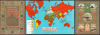
The view is oriented towards the north, likely taken from the vantage point of Thowr Mountain (جبل ثور) located southeast of the Masjid al-Haram (Great Mosque) housing the Kaaba. At left is the Makkah al-Mukarramah, that is, the Kabaa, the Great Mosque, and surrounding historic structures (many since demolished). At center-left is the valley of Mina (مِنَى), known as the 'City of Tents' where hundreds of thousands of pilgrims temporarily stay each year before undertaking the ritual of stoning the Jamarat pillars (representing the devil) and processing to Mecca. At center-right is the plain of Muzdalifah, where pilgrims stay and gather stones in preparation for stoning the pillars at Mina. And at right are the Plain of Arafat, the boundary markers at the edge of the Haram zone of Mecca, and Mount Arafat, here as the 'Mountain of Mercy' (جبل ٱلرحمة). At the bottom center, in addition to the title, is a table of distances between important points along the Hajj procession, divided into columns: Mecca to Mina and Mina to Arafat. As explained at bottom, the calligraphic text (Qur'anic verses) surrounding the view is the same that appears on the Kiswah, the sacred black silk cloth covering the Kabaa.The verso is divided into three sections, with those at left and right resembling the ornate prayer rugs used by Hajj pilgrims and other Muslims to pray while facing towards Mecca and specifically the Kabaa. The text in the panel at left are verses from the Quran pertaining to the obligation to go on pilgrimage for those able to, as well as the Qibla. The panel on the right includes illustrated views of the Kaaba, the Prophet's Mosque (Al-Masjid an-Nabawi) in Medina, the Dome of the Rock in Jerusalem, the Umayyad Mosque in Damascus, and the Imam Hussain Shrine complex in Karbala, Iraq. At the center is a world map that shades countries according to whether they are Muslim (or contain a significant Muslim population) and whether they are aligned with the Allies or the Axis in the ongoing Second World War (or neutral or under Axis occupation). Arabia stands out for being solidly green - Muslim lands neither under Allied protection nor Axis occupation.
Historical Context
Aside from its aesthetic qualities, this view is notable for being produced in the midst of the World War I (1914 - 1918), as the map on the verso indicates. During World War II, Saudi Arabia maintained official neutrality nearly until the end of the war while aligning closely with the Allies. This arrangement helped solidify the country's close alignment with the West, and especially the U.S.A., which would be very beneficial to both parties in the Postwar period. But the wartime years saw the country face an economic crisis caused by the near-total collapse of the Hajj. As maritime blockades, Axis naval threats, and Allied wartime travel restrictions severely restricted international shipping, the annual influx of overseas pilgrims plummeted from tens of thousands to a mere trickle of local and regional attendees. Because pilgrimage tariffs and services were Saudi Arabia's primary source of national revenue and foreign currency, the sudden collapse left King Abdulaziz's government in severe financial distress, struggling to pay civil servants or import adequate food supplies.To prevent humanitarian disaster and secure regional stability, the Saudi state instituted strict rationing and local health protocols in the Hejaz, while the Allies stepped in to prop up the Saudi administration of the Holy Sites. Great Britain initially supplied financial subsidies and emergency grain, followed in 1943 by the United States extending direct Lend-Lease assistance to Riyadh, recognizing that Saudi state solvency was vital to the Allied war effort. Ultimately, the loss of pilgrimage revenues motivated King Abdulaziz to further expedite petroleum development with American concessionaires (the predecessor to Aramco), dramatically altering the country's future trajectory.
Publication History and Census
This view is unattributed, but the title explains that it is 'transcribed from the book Mir'at al-Haramayn [Mirror of the Two Holy Sanctuaries] by the Commander of the Hajj Pilgrimage, Major General Ibrahim Rifat Pasha.' The book itself (first published in 1925) contains dozens of photographs, maps, and diagrams, but not a view such as the present one. Instead, the present work appears to have collated information from several of Ibrahim Rifat Pasha's photographs and maps. As for Ibrahim Rifat Pasha, he had died in 1935 after a distinguished career in the Egyptian military, including as the 'Commander' of caravans of Egyptian Hajj pilgrims for several years in the first decade of the 20th century. Drawing on these experiences and his photography hobby, Ibrahim Rifat Pasha wrote Mir'at al-Haramayn, which became perhaps the most popular Hajj account of the era, in part as it included some of the earliest published photographs of the Kabaa, the Great Mosque, and other key sites in the Hejaz.The present view is quite rare, only being cataloged among the holdings of the British Library, the Victoria and Albert Museum, and National Library of Israel. All three institutions suggest a date of c. 1942 and publication in Jerusalem / Palestine.
Condition
Good. Wear along original fold lines. Creasing.
References
OCLC 40510811, 1399455558.