This item has been sold, but you can get on the Waitlist to be notified if another example becomes available, or purchase a digital scan.
1851 Morgan Map of New York under the Iroquois: Ho-De'-No-Sau-Nee-Ga
HoDeNoSauNeeGa-morgan-1851$1,750.00

Title
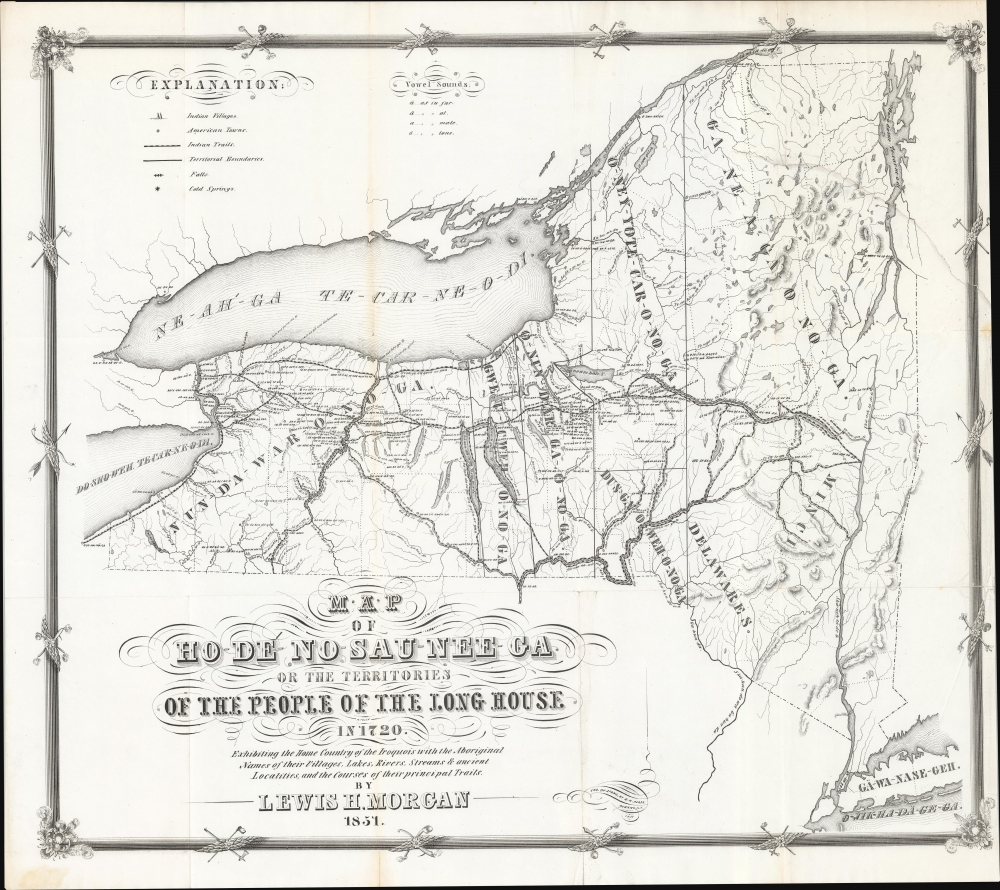
Map of Ho-De'-No-Sau-Nee-Ga or the Territories of the People of the Long House in 1720. Exhibiting the Home Country of the Iroquois with the Aboriginal Names of their Villages, Lakes, River, Streams and Ancient Localities, and the courses of their principal Trails.
1851 (dated) 19 x 21.5 in (48.26 x 54.61 cm) 1 : 1250000
1851 (dated) 19 x 21.5 in (48.26 x 54.61 cm) 1 : 1250000
Description
This is the rare 1851 first edition of 'Father of American Anthropology' Lewis Henry Morgan and Seneca Sachem Ely S. Parker's map of New York as it existed under the Iroquois League c. 1720. This novel work is one of the few maps published in the 19th century to directly detail American Indian lands, routes of travel, and language. It is considered the first scientific representation of an American Indian Tribe on a map.
Coverage extends from around what became Erie, Pennsylvania, to the Hudson River, and stretching south to Long Island, Manhattan, and Staten Island at bottom-right, although the focus is on Upstate New York. Detail is most focused on the important corridor between the Niagara River and the Hudson River, including the Finger Lakes region. Many of the indigenous names have clear connections with their modern Anglicizations, such as Cha-da-quet (Chataqua), Gen-nis-hee-yo (Genesee), Ne-ah-ga (Niagara), Gwa-u-gweh (Cayuga), and so on. The novel decorative border features American Indian implements and weapons, including pipes, clubs, and tomahawks.
A Closer Look
The title refers to Haudenosaunee ('People of the Long House'), the indigenous name of the Iroquois Confederacy or Five Nations (later Six Nations), consisting of the Mohawk, Oneida, Onondaga, Cayuga, Seneca, and, from 1722, the Tuscarora. The map is a product of meticulous research that overlays Iroquois data, including placenames, trails, villages, and more, on a geographically modern map of New York State.Coverage extends from around what became Erie, Pennsylvania, to the Hudson River, and stretching south to Long Island, Manhattan, and Staten Island at bottom-right, although the focus is on Upstate New York. Detail is most focused on the important corridor between the Niagara River and the Hudson River, including the Finger Lakes region. Many of the indigenous names have clear connections with their modern Anglicizations, such as Cha-da-quet (Chataqua), Gen-nis-hee-yo (Genesee), Ne-ah-ga (Niagara), Gwa-u-gweh (Cayuga), and so on. The novel decorative border features American Indian implements and weapons, including pipes, clubs, and tomahawks.
The Iroquois League
The Iroquois League was a powerful and sophisticated confederacy of indigenous tribes in Northeastern North America. Comprising the Mohawk, Oneida, Onondaga, Cayuga, and Seneca nations, the League maintained an advanced political system characterized by a constitution known as the Great Law of Peace. This structure allowed the Iroquois to maintain a balance of power among the member tribes and effectively manage their vast territory, which spanned from modern-day New York into the Great Lakes region. The Iroquois were renowned for their diplomatic skills, playing a crucial role in the regional power dynamics between European colonial powers, such as the French and English, and other Native American tribes. Their society was marked by a matrilineal system, where descent and inheritance were traced through the female line, and women held significant power. As skilled warriors and strategic thinkers, the Iroquois had a profound regional influence on the political, social, and economic landscape, as well as a long-term global influence in that their system of governance and constitution played a role in the ideas behind the U.S. Constitution. Some Iroquois still live in New York State, but in 1779 most were driven from their hereditary lands in retaliation for their alliance with Great Britain in the American Revolutionary War (1775 - 1783).Publication History and Census
This map was compiled in 1851 by Iroquois expert Lewis H. Morgan and the Seneca sachem (also civil engineer and lawyer) Ely S. Parker. It is loosely based on French maps of 1720 or earlier, showing ancient trails, lakes, villages, and principal locations with their aboriginal names. The work was engraved in Albany by Richard H. Pease. It was published for Morgan's, League of the Ho-De'-No-Sau-Nee, or Iroquois (Rochester, 1851). The work, and the map were republished in 1901, wherein both the map and the illustrations were colorized. We believe that most surviving examples, including those in institutions, are actually from this latter edition, as they are all colored. Uncolored examples, as here, universally correspond with the few verified examples of the first edition. Due to inconsistent cataloging and erroneous association of the 1901 reprint with the 1851 original, it is difficult to perform a comprehensive census of institutional holdings of the separate map. We see only one example of the 1851 edition of the book in OCLC: Queens University Library, Ontario.CartographerS
Lewis Henry Morgan (November 21, 1818 – December 17, 1881) was an American expert on the Native American cultures of Upstate New York and a founder in the field of ethnology. Expanding on his research on the Iroquois, he developed wide-ranging social theories that were influenced by a superficial interpretation of Darwinism and his own misinterpretation of Haudenosaunee (Iroquois) society. Nevertheless, as an early work in the developing field of ethnology, Morgan's ideas were influential, including on Karl Marx and Friederich Engels, particularly their notion of 'primitive Communism,' due to Morgan's emphasis on the role of the family and property in social evolution. He had a long and significant friendship with Ely Parker, the first Native American Commissioner of Indian Affairs, but the two had something of a falling out when President Ulysses Grant chose Parker instead of Morgan for that post. More by this mapmaker...
Ely Samuel Parker (1828 – August 31, 1895), born Hasanoanda, later known as Donehogawa, was a Seneca U.S. Army officer, engineer, and tribal diplomat. Born on the Tonawanda Reservation in Indian Falls, New York to a prominent Christian Seneca family, his family frequently interacted with white American scholars interested in the history of the Native Americans of the region, including Lewis Henry Morgan. Like Morgan, Parker trained as a lawyer but later attended the Rensselaer Polytechnic Institute and studied civil engineering. During the 1850s, he helped to upgrade the Erie Canal and also acted as an interpreter for treaty negotiations between the U.S. government and the Seneca nation. Around this time, he met Ulysses S. Grant, who later took Parker on as a member of his staff during the Civil War, a role in which he helped to draft the documents of surrender at Appomattox Courthouse. When Grant became president in 1869, he nominated Parker as Commissioner of Indian Affairs, where Parker pursued a policy of negotiation in place of military actions with Native American tribes in the American West. However, this proved difficult to enact in practice. The guiding philosophy, shared by Parker, was that Native Americans should be moved to reservations and (forcibly) assimilated into American society, which many were not willing to do, especially once they discovered the barren lands that had been assigned to them. When resistance turned to violence, Grant was pressured into using military force in response. Parker himself became the object of corruption charges lobbed by competing 'experts' on Indian affairs who coveted his job, and his authority was curtailed as a result. He resigned in protest in 1871. Learn More...
Richard H. Pease (1813 - 1869) was an American merchant and lithographer active in Albany, New York, during the middle part of the 19th century. Pease is best recognized for his publication of America's first Christmas card for the 1849 -1850 holiday season. He also played a role in populating the American version of Santa Claus and tying it to consumerism in the holiday advertisements his produced for his 'Temple of Fancy or Pease's Great Variety Store.' Pease operated the Great Variety Store in tandem with his lithography business until he passed the store on to his son, Harry E. Pease, in 1855. The store was located at 516 Broadway, Albany. Pease also published hand-colored lithographs of fruit for Ebenezer Emmons’s book Agriculture of New York State, published between 1846 and 1854. From 1856 to 1867 he worked with the lithography firm of Hoffman, Knickerbocker and Co. Learn More...
Source
Morgan, L. H., League of the Ho-De'-No-Sau-Nee, or Iroquois, (Rochester: Sage and Brother) 1851.
Condition
Very good. Large closed and repaired tear extending from the right side about 5 inches into the map. Light wear on old fold lines.
References
OCLC 932868590.