
1944 Defence Overprint Map of Part of the Border Region between the Netherlands and Germany

This item has been sold.
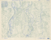
Holland and Germany 1: 25,000 Defence Overprint Sheet F (Rhine) Edition of 31 Oct 44.
Planning an Allied operation across the River Maas.
- Digital Map Information
- Suitable for large format printing
- Full resolution TIFF file
- ICC color profile embedded
- Delivered instantly via download link
Planning an Allied operation across the River Maas.
This is an October 1944 World War II Defence Overprint map of the southeastern Netherlands and eastern Germany. The map was compiled from aerial photography during the planning stages of an Allied offensive across the River Maas.A Closer Look
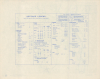
Coverage embraces part of the Dutch/German border region along the River Maas between Broekhuizenvorst and Laarberg and from Homburg, Netherlands, in the west to Niersken, Germany, in the east. The blue overprinting marks German defensive positions, including machine gun emplacements, trenches, antitank ditches, and antiaircraft gun positions. A diagram in the upper left details when each area was photographed.Historical Context
This map was created on October 31, 1944, to plan a major Allied offensive across the River Maas and into Germany. The Allied commanders met in Maastricht on December 7, 1944, to discuss plans for maintaining pressure on the Germans through the winter, and the proposed offensive across the River Maas was tentatively set for January 1, 1945. These plans were put on hold a little over a week later when the Germans launched their doomed offensive in the Ardennes Forest (Battle of the Bulge).Publication History and Census
The base map was created by the Geographical Section, General Staff, and published by the War Office in 1944. This variant edition was revised by an engineering company in the field on October 31, 1944. This is the only known surviving example. The Directorate of History and Heritage at the Canadian Department of National Defence Fonds has an example of the same sheet with defence overprinting dated February 14, 1945, six days after the launch of Operation Veritable (RG24M 1997-02033-5, Box number: 2000850741).Cartographer
The British War Office (1857 - 1964) was a department of the British Government responsible for the administration of the Royal Army until 1964, when its functions were transferred to the Ministry of Defense. The War Office was to the Royal Army what the Admiralty was to the Royal Navy, and later, the Air Ministry. Within the War Office, the General Staff Topographical Section was responsible for thousands of maps issued for British intelligence and military use. The Topographical Section was renamed Geographical Section in April 1907. Many, once their military use passed, were offered through licensed agents to the general public. The sole London agent for War Office material was Edward Stanford. Further Details...
Condition
Excellent.