
1890 Bacon Bird's-Eye View of the Holy Land / Israel / Palestine

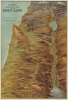

Bacon's Bird's-Eye View of the Holy Land.
Stunning view of the Holy Land!
- Digital Map Information
- Suitable for large format printing
- Full resolution TIFF file
- ICC color profile embedded
- Delivered instantly via download link
Stunning view of the Holy Land!
A scarce c. 1890 chromolithograph bird's-eye view of the Holy Land, Israel, and Palestine, published in London by G. W. Bacon. Brilliantly colored and rendered from an elevated oblique perspective, the view presents the Biblical landscape from Mount Lebanon and Mount Hermon south along the Jordan River Valley, encompassing the Sea of Galilee, Jerusalem, Bethlehem, and the Dead Sea. Bacon dramatically exaggerates key geographical features, transforming the ancient Biblical landscape into an immediately comprehensible three-dimensional panorama.A Closer Look
Coverage extends from Mt. Lebanon and Mt. Hermon to the Dead Sea, Bethlehem, and Gath, covering the northern half of modern-day Israel and southern Lebanon. The Jordan River valley is particularly striking, with bold exaggerated depictions of both the Sea of Galilee and the northern part of the Dead Sea. Jerusalem is prominent at the bottom center.Chromolithography
Chromolithography is a color lithographic technique developed in the mid-19th century. The process used multiple lithographic stones, one for each color, to create a rich composite effect. Often, the process started with a black basecoat, on which subsequent colors were layered. Some chromolithographs used 30 or more separate lithographic stones to achieve the desired product. Chromolithograph color could also be effectively blended for even more dramatic results. The process became extremely popular in the late 19th and early 20th centuries, when it emerged as the dominant method of color printing. The vivid color chromolithography produced made it exceptionally effective for advertising and propaganda imagery.Publication History and Census
This wall map was issued by G. W. Bacon from his offices at 127 Strand, London. The map is undated, but likely appeared between 1880 and 1900 - during the height of the chromolithography craze. Bacon sold his business to W. and A. K. Johnston in 1900, so it must predate that transfer. We have seen examples of this map reduced to postcard format but know of only two other full-sized examples in private hands. Not in OCLC.Cartographer
George Washington Bacon (1830 - 1922) was a London based book and map publisher active in the mid to late 19th century. Bacon's firm G.W. Bacon and Co. purchased the plates created by Edward Weller for the Weekly Dispatch Atlas then modified and updated them for several of their own important atlases, including The New Ordnance Atlas of the British Isles. In 1893, Bacon & Co. acquired the map publishing business of J. Wyld. Then, around the turn of the century, Bacon & Co. itself was folded into the Scottish publishing house of W.& A.K. Johnston. Further Details...
Condition
Average. Wear on old fold lines. Some color fill in the upper left near the word 'Mediterranean'. Laid down on archival tissue. Normally a 2500 USD view. Here price reduced accordingly.