This item has been sold, but you can get on the Waitlist to be notified if another example becomes available, or purchase a digital scan.
1579 Ortelius Map of Hungary
Hungary-ortelius-1579$475.00

Title
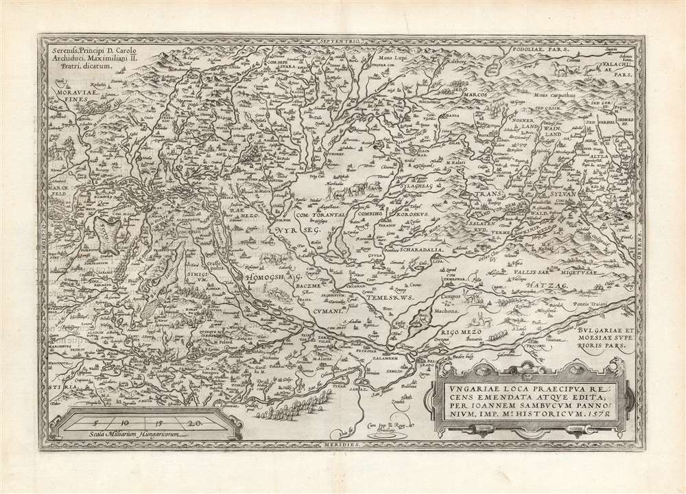
Ungariae Loca Praecipua Recens Emendata Atque Edita, per Ioannem Sambucum Pannonium, Imp. Ms. Historicum. 1579.
1579 (dated) 13.5 x 19.5 in (34.29 x 49.53 cm) 1 : 1200000
1579 (dated) 13.5 x 19.5 in (34.29 x 49.53 cm) 1 : 1200000
Description
This is Ortelius' updated map of Hungary, derived from the similarly-titled and unacquirable 1571 map of János Zsámboky aka Johannes Sambucus. This new map supplemented Ortelius' earlier map of Hungary, based on the much older (1556) map of Wolfgang Lazio.
Lazio and Sambucus
While Ortelius trusted the Lazio sufficiently to retain it in his atlas throughout its print history, he esteemed Sambucus as a clear-eyed and well-traveled scholar, and would include at least three of the Hungarian's maps in the Theatrum, including this one. There are numerous changes in toponymy; for example, the city at the confluence of the Sau and the Danube is here named Belgrado, as opposed to the antiquated German Griechschweissenburg appearing on the Lazio. The course of the Danube stretching from Vienna to modern-day Romania and Serbia; the remains of Trajan's bridge across the Danube are marked on the map.An Evocative Engraving
The mountainous terrain is depicted pictorially, as well as the forests and the wetlands southwest of the Danube. The region of Timisoara north of the Danube is decorated with deer; other areas north of the Danube are embellished with flocks of sheep, and herds of cattle - perhaps suggesting that those lands, then under Turkish domination, might be a valuable prize.Publication History and Census
This map was engraved in 1579 and first included in the 1579 Latin edition of Ortelius' Theatrum. The present example conforms typographically to the 1581 French text edition, of which van den Broecke estimates there were four hundred printed. Nine examples of that edition of the book are listed in OCLC. Twenty-five examples of the separate map, in various editions, appear institutional collections.CartographerS
Abraham Ortelius (April 14, 1527 - June 28, 1598) also known as Ortels, was a cartographer, geographer, and cosmographer of Brabant, active in Antwerp. He was the creator of the first modern atlas, Theatrum Orbis Terrarum and is a seminal figure in the history of cartography. Along with Gerard Mercator and Gemma Frisius, he was a founder of the Netherlandish school of cartography. His connections with Spain - culminating in his 1575 appointment as Royal Cartographer to King Phillip II of Spain - gave him unmatched access to Spanish geographical knowledge during a crucial period of the Age of Discovery. Ortelius was born in 1527 in Antwerp. In 1547 he entered the Antwerp Guild of Saint Luke as an illuminator of maps. He began trading in books, prints, and maps, traveling regularly to the Frankfurt book and print fair, where in 1554 he met Mercator. He accompanied Mercator on journeys throughout France in 1560 and it was at this time, under Mercator's influence, that he appears to have chosen his career as a scientific geographer. His first published geographic work appeared in 1564, an eight-sheet cordiform world map. A handful of other maps preceded the 1570 publication of the first edition of the Theatrum Orbis Terrarum, which would prove to be his life work. Appearing with but 53 maps in its first edition, Ortelius' work expanded with new maps added regularly. By 1592, it had 134 maps. Many of Ortelius' maps remained the standard for nearly a century. He traveled extensively, but his genius was as a compiler, locating the best informed maps on which to base his own. His contacts throughout Europe and extending even (via the Portuguese) to the Far East were formidable. Moreover, many of his maps were based on his own scholarship, particularly his historical works. His theories of geography were particularly ahead of his time with respect to the notion of continental drift, the possibility of which he mused on as early as 1596, and which would be proven correct centuries later.
In a sense his greatest achievement was his successful navigation of the religious and political violence endemic to his city throughout his adult life: The Dutch Revolt, or Eighty Years' War (1568 - 1648), fully embroiled Antwerp. Although outwardly and officially recognized as Catholic (Arias Montanus vouched for Ortelius' Catholic orthodoxy prior to his appointment as Royal Geographer), Ortelius was able to separate himself from the religious furor which characterized the war in the low countries. Ortelius showed a glimpse of himself in a letter to a friend, regarding humanist Justus Lipsius: 'I do not know whether he is an adherent of the Pope or a Calvinist, but if he has ears to hear, he will neither be one nor the other, for sins are committed on both sides'. Ortelius' own explorations of Biblical history in his maps, and the Christogram contained in his own motto, suggest him to be a religious man, but his abjuration of political religious authorities mark him as an individualist. His tombstone at St Michael's Præmonstratensian Abbey in Antwerp bears the inscription, Quietis cultor sine lite, uxore, prole. ('served quietly, without accusation, wife, and offspring.') More by this mapmaker...
János Zsámboky, or Johannes Sambucus,(June 1, 1531 - June 13, 1584) was a Hungarian humanist polymath. He is best known for his emblem book, Emblemata cum aliquot nummis antiqui operis, published in five editions starting in 1564. He had studied in Vienna, but traveled broadly: he studied and worked in Leipzig, Wittenberg, Ingolstadt, Strasbourg, Paris, Venice, Padua, Genoa, Naples, Milan, Ghent, and Antwerp. He would be appointed court physician of Emperor Maximilian II, and prospered in that association, allowing him to amass wealth, influence, and an impressive library. His works included several maps - Hungary, Transylvania and Illyricum - which provided the basis for Abraham Ortelius' maps of those regions. Ortelius' decision to use Sambucus' maps speaks both to his influence, as well as a shared interest: Like Ortelius, Sambucus collected coins. Learn More...
Source
Ortelius, A., Theatre de l'univers, contenant les cartes de tout le monde, (Antwerp) 1581.
Condition
Excellent. Few small filled marginal wormholes not impacting printed image.
References
OCLC 699732769.