
1771 Bonne Map of India, East Indies, Southeast Asia, and the Philippines

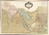

Carte Hydro-Geo-Graphique des Indes Orientales en deca et au dela du Gange avec leur Archipel Dressee et assujettie aux Observations Astronomiques.
Colonial Competition in the East Indies.
- Digital Map Information
- Suitable for large format printing
- Full resolution TIFF file
- ICC color profile embedded
- Delivered instantly via download link
Colonial Competition in the East Indies.
This is Rigobert Bonne's 1771 map of South and Southeast Asia (the East Indies) that appeared in Jean Lattre's 1778 edition of the Atlas Moderne - here in a full color joined example. It depicts the region during a period of competition between colonial empires in the aftermath of the Seven Years' War (1756 - 1763).A Closer Look
Printed on four sheets, which are joined and hand-colored, the map covers from the Arabian Sea to the Philippines, and from Tibet and southern China to Java and Timor (Indonesia). Several territories are labeled, including the Kingdom of Siam (Thailand), Laos, Tonkin (northern Vietnam), Cochin China and Champa (southern Vietnam), the island of Hainan, Formosa (Taiwan), and the Island of Luzon (northern Philippines). Macao and Canton are recorded, while Hong Kong Island is shown but not labeled, as is the case with Singapore, though the Strait of Singapore (Sin Capura) is labeled. The Paracel Islands and several other archipelagos are highlighted, with their sizes exaggerated to reflect their importance for navigation. Waterways and mountains are indicated in remarkable detail throughout. On the water, rhumb lines, shoals, and currents are recorded, with a note at upper-right explaining the trade winds and monsoons.Historical Context
This map was prepared in the era when European colonial empires were still actively fighting and vying for influence in the East Indies before settling into 'spheres of influence' in the 19th century. Most notably, the Seven Years' War (1756 - 1763) had resulted in the establishment of British dominance of India, while the French were relegated to a minor role on the Subcontinent. More promising for France was a growing missionary presence in Cochinchina, which, soon after this map's publication, resulted in an alliance with Nguyễn Ánh, who would rule as the Gia Long Emperor. Meanwhile, the Dutch had a well-established presence on Java and Maluku, with trading posts throughout the archipelago, while the Spanish were installed at Manila. Although not controlled by European powers, Canton was also an essential part of the East Indies trade system, serving as the end point of most voyages. At this time, Western traders operated trading posts ('factories') on Shamian Island, within a tightly controlled yet still highly lucrative trade system.In the following years, much would change as a result of the Age of Revolutions and the Napoleonic Wars (1803 - 1815). Some territories, such as the Dutch holdings in Indonesia, were briefly occupied by the British. Others were ceded at the end of the conflict, such as Ceylon (Sri Lanka), which passed from Dutch to British control. The end of the Napoleonic Wars signaled Britain's clear maritime hegemony and prompted the further expansion of her maritime empire, with crucial trading posts at Singapore (1819) and Hong Kong (1842) being established and existing ones growing considerably.
Publication History and Census
This map was prepared by Rigobert Bonne in 1771 for issue in Jean Lattre's 1778 edition of the Atlas Moderne. It is independently cataloged at Northern Illinois University, Cornell University, the University of British Columbia, the Hong Kong University of Science and Technology, the National Library Board of Singapore, the Universitätsbibliothek Bern, and the David Rumsey Historical Map Collection.Cartographers
Rigobert Bonne (October 6, 1727 - September 2, 1794) was one of the most important French cartographers of the late 18th century. Bonne was born in Ardennes à Raucourt, France. He taught himself mathematics and by eighteen was a working engineer. During the War of the Austrian Succession (1740 - 1748), he served as a military engineer at Berg-op-Zoom. In the subsequent years, Bonne became one of the most respected masters of mathematics, physics, and geography in Paris. In 1773, Bonne succeeded Jacques-Nicolas Bellin as Royal Cartographer to France in the office of the Hydrographer at the Depôt de la Marine. Working in his official capacity, Bonne compiled some of the most detailed and accurate maps of the period, most on an equal-area projection known erroneously as the 'Bonne Projection.' Bonne's work represents an important step in the evolution of the cartographic ideology away from the decorative work of the 17th and early 18th century towards a more scientific and practical aesthetic. While mostly focusing on coastal regions, the work of Bonne is highly regarded for its detail, historical importance, and overall aesthetic appeal. Bonne died of edema in 1794, but his son Charles-Marie Rigobert Bonne continued to publish his work well after his death. Further Details...
Jean Lattré (170x - 178x) was a Paris based bookseller, engraver, globe maker, calligrapher, and map publisher active in the mid to late 18th century. Lattré published a large corpus of maps, globes, and atlases in conjunction with a number of other important French cartographic figures, including Janvier, Zannoni, Bonne and Delamarche. He is also known to have worked with other European cartographers such as William Faden of London and the Italian cartographer Santini. Map piracy and copyright violations were common in 18th century France. Paris court records indicate that Lattré brought charges against several other period map publishers, including fellow Frenchman Desnos and the Italian map engraver Zannoni, both of whom he accused of copying his work. Lattré likes trained his wife Madame Lattré (né Vérard), as an engraver, as a late 18th century trade card promotes the world of 'Lattré et son Epouse.' Lattré's offices and bookshop were located at 20 rue St. Jaques, Paris, France. Later in life he relocated to Bordeaux. Further Details...
Source
Lattre, Jean, Atlas Moderne ou Collection de Cartes sur Toutes les Parties du Globe Terrestre, c.1778.
Condition
Good. Four sheet, joined. Full color. A few minor verso repairs and reinforcements. Some old foxing - neutralized.
References
Rumsey 2612.055. Phillips (Atlases) 664. National Maritime Museum, 215. OCLC 7476673, 861246704, 605256087.