This item has been sold, but you can get on the Waitlist to be notified if another example becomes available, or purchase a digital scan.
1786 Tofino Nautical Chart or Map of Ibiza, Spain
Ibiza-tofnio-1786$1,250.00

Title
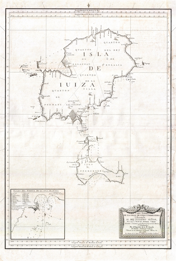
Carta Esférica de las Islas de Iuiza y Formentera;Presentada al Rey Nuestro Señor, Por el Emo. Sr. Bº. Fr. Dn. Antonio Valdés, Secretario de Estado, y del Despacho Universal de Marina;Y Construida Por el Brigadier de la Rl. Armada Dn. Vicente Tofiño de Sn. Miguel, Director de las Academias de Guardias Marinas &c.
1786 (dated) 35 x 24 in (88.9 x 60.96 cm) 1 : 81300
1786 (dated) 35 x 24 in (88.9 x 60.96 cm) 1 : 81300
Description
An extremely rare large scale 1786 Spanish nautical chart detailing the Balearic Islands of Ibiza and Formentera by the famed hydrographers Vincente Tofiño de San Miguel and Antonio Valdés y Fernández Bazán. The map covers both islands in full with light shoreline detail and soundings along the southern coastline of both islands. An inset map the lower left details the port city of Ibiza with 20 important buildings identified alphanumerically. The map is beautifully engraved with villages represented by tiny finely etched illustrations of churches. A rococo title cartouche appears in the lower right quadrant.
Today Ibiza has become a playground for Europe's elite. It is known for its sundrenched beaches, historical architecture, electronic music scene, and vibrant nightlife. In 1999 it became a UNESCO World Heritage Site.
At the command of Valdés, Tofiño surveyed the Balearic Islands between 1783 and 1788. The results of their work appear to have been issued first independently then bound into various composite nautical atlases from about 1788. The present map was engraved by Simón Brieva.
CartographerS
Vincente Tofiño de San Miguel (September 6, 1732 - 1795) was a Spanish naval officer and hydrographer active in the second half of the 18th century. Tofiño was born in Cadiz, Spain. His father, a career army officer, died in the 1746 Battle of Placentia, leaving Vincente an orphan from age 14. He moved to Extremadura where his uncle, a priest, raised him. In 1750, following in his father's footsteps, he joined the army. Having discovered a proficiency in mathematics, Tofiño was assigned to an artillery unit. In 1755, moving from the army to the navy, where his skills were better suited, he became a professor of mathematics at the Academia de Guardia Marinas de Cádiz. He would remain in the navy for the subsequent 30 years, ultimately attaining the rank of Rear Admiral. Between 1783 and 1788, as a navy officer, astronomer, and hydrographer, he was deployed to survey the Mediterranean ports of Spain, the Balearic Islands, and the Barbary Coast. He trained the explorers Dionisio Alcalá Galiano and Cayetano Valdés y Flores Bazán, who named Tofino Inlet, in Vancouver, after him. Tofiño was elected correspondent of the Spanish Academy of History and of the French and Portuguese Academies of Science. He died in Cadiz in 1795. More by this mapmaker...
Antonio Valdés y Fernández Bazán (1744 – April 4, 1816) was a Spanish naval officer active in the latter part of the 18th century. He was born In Burgos, Spain, and entered the navy at age 13. He distinguished himself in the defense of Morro Castle and San Salvador de la Punta Fortress during the Battle of Havana (1762). He also fought against the Barbary Coast pirates in 1767. In 1781, he became director of the Royal Artillery Factory of La Cavada, and reorganized it to that extent that he was promoted to become inspector general of the Spanish Navy. In 1783, at the age of 38, he became Navy Minister and continued the modernization of the Spanish Navy. He became a knight in the Order of the Golden Fleece in 1797. His nephew, the explorer Cayetano Valdés y Flores, named Valdez, Alaska and Valdez, Florida, after him. Learn More...
Jonas Carl Frederik Washer Haas (1720 - April 10, 1775) was a Nuremberg-born artist and engraver active in Copenhagen, Denmark, in the middle to late 18th century. Haas was born in Nuremberg in 1720. After several years in Hamburg, Haas relocated to Copenhagen along with several other of his fellow artists, including Johan Martin Preisler and Carl Marcus Tuscher. In 1755, Haas was appointed official engraver for the University of Copenhagen. In addition to numerous portraits, he engraved maps for Johan Jacob Bruun's Novus Atlas Daniæand, and vignettes of Frederik Ludvig Norden's Travels. In Hamburg, he had married Anna Rosine Fritsch, the daughter of a fellow engraver, with whome he had four children. Three of his sons, Georg, Meno, and Peter were also engravers. Haas is interred at St. Peter's church cemetery. Learn More...
Condition
Very good. Minor wear and verso reinforcement on oriignal centerfold. Minor water stains to outer margins.
References
Biblioteca Nacional de Espana, GMG / 122 MAP 9.