
1929 Survey of India Road Map of India w/ Manuscript Notations

This item has been sold.
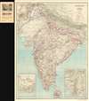
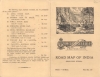
Road Map of India (Excluding Burma).
India on the eve of the Great Depression.
- Digital Map Information
- Suitable for large format printing
- Full resolution TIFF file
- ICC color profile embedded
- Delivered instantly via download link
India on the eve of the Great Depression.
This is a 1929 Survey of India road map of India published under Brigadier Robert Henry Thomas.A Closer Look
Covering the subcontinent, the map focuses on India's growing road system, also detailing railroads, rivers, regional boundaries, and mileage (green). It offers a unique insight into the development of the road system. Three road grades are identified: through routes (heavy red lines), other main roads (thinner red lines), and 'motorable' roads subject to weather (thinnest red lines). Areas where delays are likely are also annotated.Manuscript Notations
Green manuscript notations trace a trip from Bombay across India to Calcutta and then south along the coastline to Madras, Bangalore, Madura, and Trivandrum. Other cities are underlined in green, including Sholapur, Lahore, and Peshawar.Publication History and Census
This map was created and published by the Survey of India under the direction of Brigadier Robert Henry Thomas in 1929. Four examples are cataloged in the OCLC: Harvard College, Duke University, the University of Chicago, and the University of Oxford.Cartographers
Survey of India (1767 - Present) is India's central engineering agency in charge of mapping and surveying the country. It was founded in 1767 by Major James Rennell, who took the post of first Surveyor General, with the mission to map and consolidate the territories of the British East India Company. The Survey undertook the Great Trigonometrical Survey between 1802 and 1852 in an attempt to accurately measure the Indian Subcontinent - considered one of the greatest feats of mapping of all time. It also sponsored clandestine surveys, at times disguised as Buddhist pilgrims, to infiltrate and map Tibet, then a closed country. With India's independence in 1947, the Survey was folded into the new Indian government, which it remains part of to this day. Further Details...
Robert Henry Thomas (April 1877 - 1946) was a British army officer and surveyor active in India. Thomas studied at St. Edmund's College and St. Paul's School. He was aware the Pollock Medal and Commissioned on June 21, 1896. He was posted to the India Service in 1908. Thomas was in charge of Geodetic Parties for a year and was then transferred to charge of the Surveyor-General's office in Calcutta. Around this time he was awarded the Distinguished Service Order (DSO). Thomas served as Surveyor General of India from 1928 - 1933. He died in London in 1946. Further Details...
Condition
Very good. Light wear along original fold lines. Attached to original binder.
References
OCLC 48710013.